
")


Staying connected with the community is a priority for the City of Southport. Our community notification system SouthportCONNECTED! gives residents, businesses, and visitors access to important emergency alerts as well as general community updates.
SouthportCONNECTED! is built on the TextMyGov communication system.
Why TextMyGov?
There are several benefits to enrolling in the SouthportCONNECTED! TextMyGov System.
- During a crisis, real-time updates can provide life-saving instructions and information.
- Notifications are on the go with you. You can receive important text alerts and updates directly to your phone.
- You’ll receive Southport-specific alerts and updates on both emergency and non-emergency topics that matter to our community.
- You’ll be notified when there are Public Services announcements or emergency situations that specifically impact your home or business.
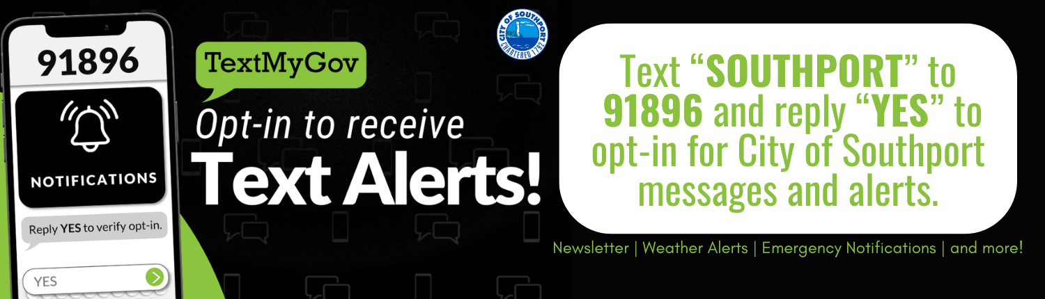
How is the City of Southport using TextMyGov to connect with the community?
The City of Southport wants to provide residents, local business owners, visitors, and employees with the most relevant information exactly when it’s needed. SouthportCONNECTED! allows us to send out text alerts and to stay in touch with community updates.
I am already enrolled in ReadyBrunswick with Brunswick County. Is this the same thing?
The SouthportCONNECTED! and TextMyGov system is not connected to the ReadyBrunswick program. You will need to sign up for this Southport-specific tool even if you already have enrolled in the County program.
Should I download any other apps?
We recommend downloading these apps to stay connected during severe weather and/or emergencies:

Click on each image below to learn more about available resources before, during, and after an emergency.

Click on each image below to learn more about available resources before, during, and after an emergency.
2025 NOAA Atlantic Hurricane Prediction – Updated August 7, 2025
The official start of the Atlantic hurricane season is June 1 and runs through November 30.
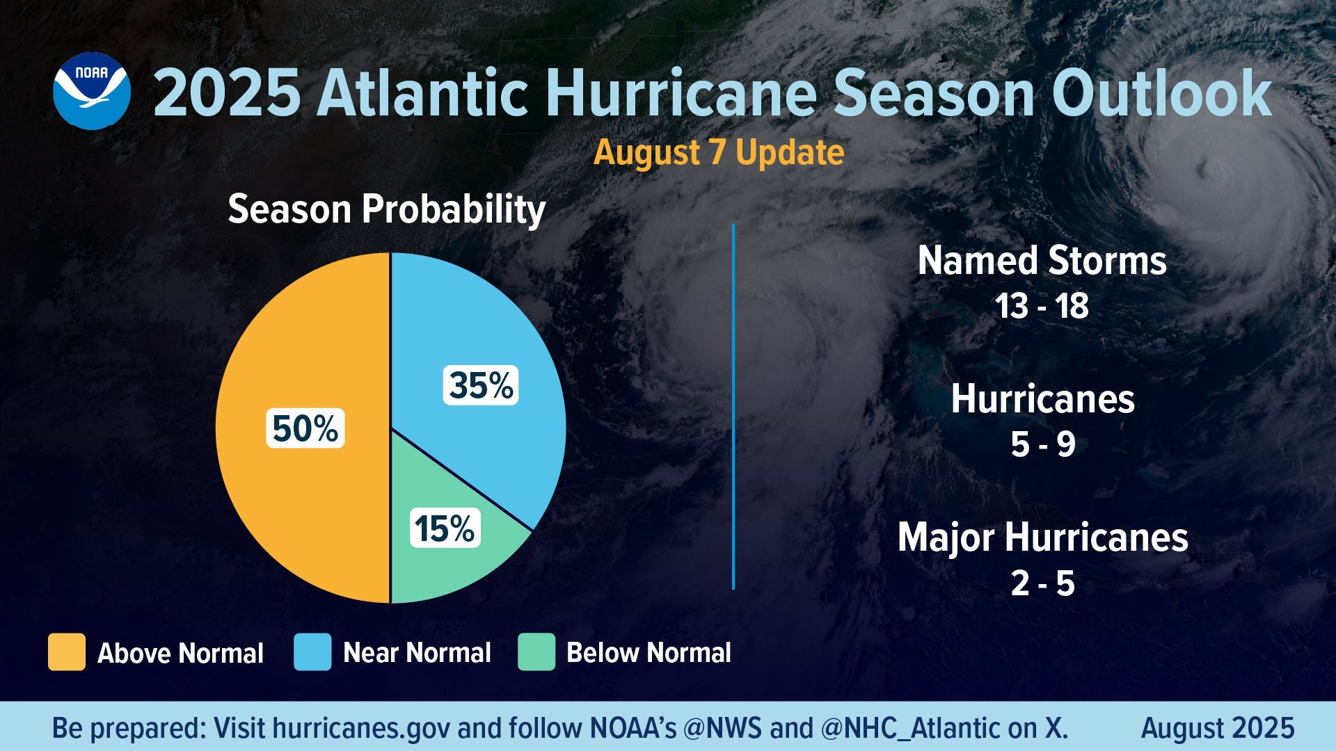
A summary infographic showing hurricane season probability and numbers of named storms predicted, according to NOAA’s 2024 Atlantic Hurricane Season Outlook. The official start of the Atlantic hurricane season is June 1 and runs through November 30. (Image credit: NOAA NWS)
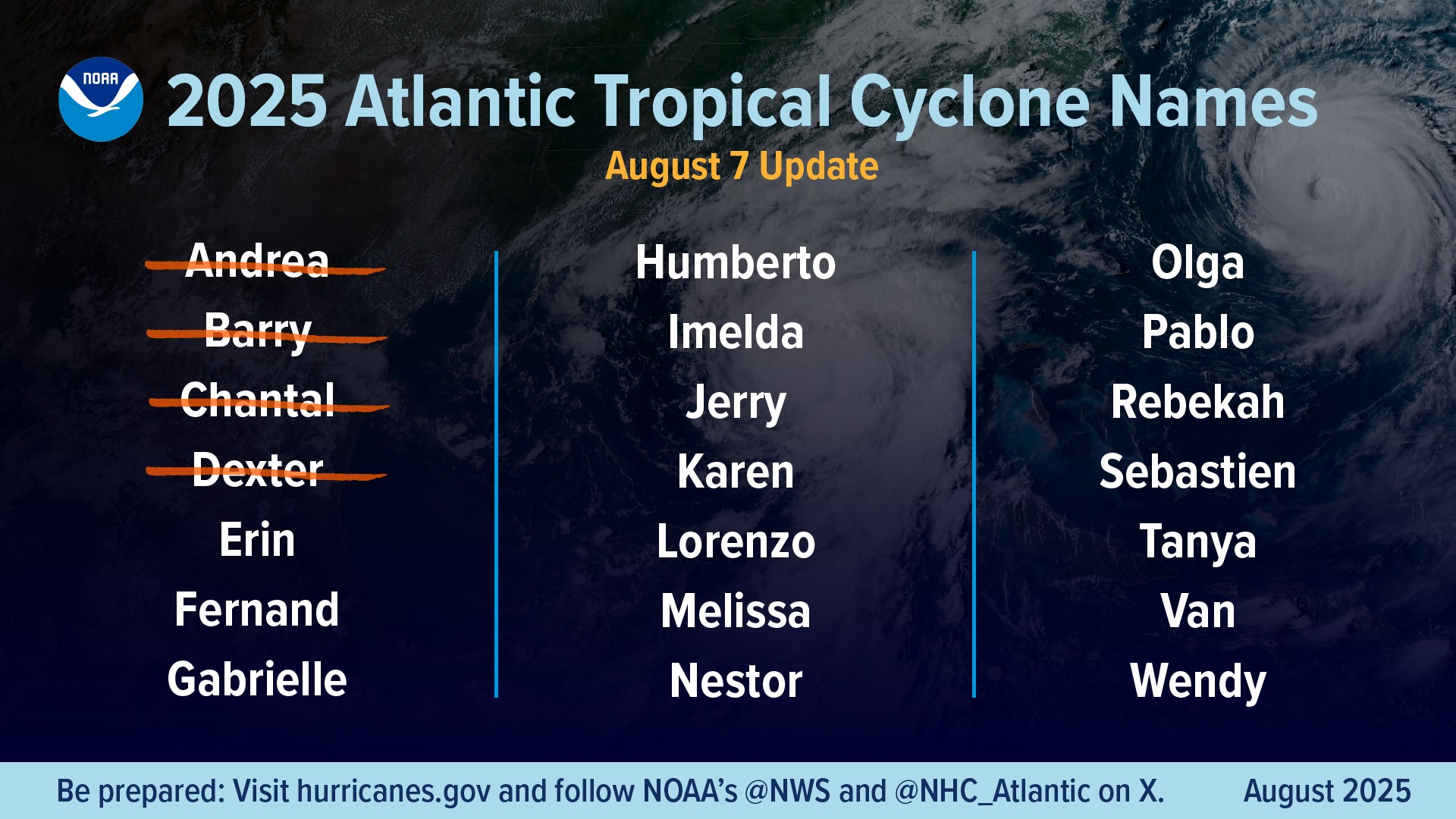
The alphabetical list of 2025 Atlantic hurricane names as chosen by the World Meteorological Organization. Find a text version of this list at hurricanes.gov/aboutnames.shtml#atl (Image credit: NOAA NWS)


Click on each image below to learn more about available resources before, during, and after an emergency.

Click on each button or image below to learn more about available resources before, during, and after an emergency.

Click on each image below to learn more about available resources before, during, and after an emergency.


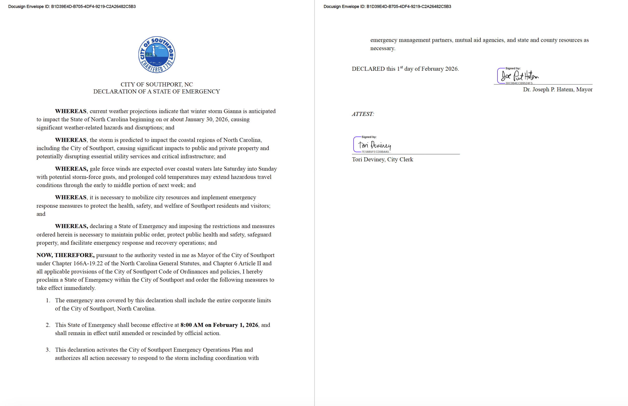
Winter Storm Gianna, January/February 2026
Questions? Contact NWS Wilmington for 24/7 forecaster assistance.
Tuesday, February 3, 2026, 11:46am, Final Update
Monday, February 2, 2026, 11:26am
The City of Southport Emergency Operations Center (EOC) participated in a Brunswick County coordination call at 10:00 AM this morning. Below is the latest update:
Brunswick County:
➡️ Brunswick County remains under a State of Emergency
➡️ The County EOC will move from Level 2 (Partial Activation) to Level 3 (Enhanced Monitoring) at 12:00 PM today
➡️ County offices are scheduled to open at 10:00 AM Tuesday morning
City of Southport:
➡️ Southport remains under a State of Emergency
➡️ If road conditions continue to improve, termination of the local State of Emergency will be recommended at 10:00 AM Tuesday, following consultation with Mayor Hatem
➡️ The City EOC will remain partially activated until 10:00 AM Tuesday morning
➡️ Fire/EMS staffing has been slightly reduced, but additional personnel remain on duty due to continued call volume and road conditions
➡️ City offices will open at 10:00 AM Tuesday morning, per the City Manager
➡️ The Police Department continues to actively monitor and report icy road conditions
➡️ Public Works is coordinating closely to maintain clear access routes and parking areas
➡️ The Public Information Office continues to provide timely updates via social media and the City website
➡️ Parks & Recreation is actively reporting conditions at City facilities and parks
The City will continue to monitor conditions and provide updates as appropriate. Thank you to all departments and partners for their continued coordination and service.
Please continue to follow official City of Southport and Southport NC Emergency Information Facebook pages and https://cityofsouthport.com/emergency-information/ for the latest updates. Stay safe and stay warm, Southport. ❄️
Sunday, February 1, 2026, 5:01pm
Latest Updates from City of Southport:
- GFL Curbside Cart Collection – No cart collection on Monday, February 2, 2026. Monday customers will receive a make up collection on Saturday, February 7, 2026. (Subject to change based on conditions).
- Brunswick County Schools – Schools will be closed for students on Monday, Feb 2 and Tuesday, Feb 3, due to the winter storm. Wednesday, Feb 4 will be a remote learning day.
- Southport Electric System – Extreme cold has raised the electric grid demand. Between 5am-10am on Monday, February 2, help us by delaying appliance use, lowering thermostats, and turning off unused devices.
Sunday, February 1, 2026, 11:02am
Sunday, February 1, 2026, 10:36am
1 February 2026
FOR IMMEDIATE RELEASE:
CITY OF SOUTHPORT
City of Southport Offices, Gym, Facilities, and Parks Closed on Monday, February 2
Contact:
ChyAnn Ketchum, Public Information Officer
910-269-7300 C | 910-457-7927 ext. 1040 O
cketchum@cityofsouthport.com
Southport, NC – City of Southport government offices, buildings, and facilities including the city gym and parks, will be closed on Monday, February 2, 2026.
Previously released information:
Roadways throughout the city are impassable, including bridges and overpasses, creating dangerous conditions for motorists and pedestrians. The combination of deep snow and sustained cold temperatures presents a serious risk to public safety and emergency response operations.
City officials urge residents to remain off the roads, avoid unnecessary travel, and stay indoors whenever possible.
Residents are encouraged to:
- Stay informed through official City of Southport communication channels
- Check on elderly neighbors and those with special needs
- Use caution with heating sources and avoid carbon monoxide hazards
- Call 911 only for true emergencies
The City will continue to monitor weather conditions closely and provide updates as new information becomes available.
For the latest updates, visit www.cityofsouthport.com and follow the City of Southport on official social media channels.
###
Sunday, February 1, 2026, 8:47am
1 February 2026
FOR IMMEDIATE RELEASE:
CITY OF SOUTHPORT
City of Southport Declares State of Emergency Due to Severe Winter Storm Conditions
Contact:
ChyAnn Ketchum, Public Information Officer
910-269-7300 C | 910-457-7927 ext. 1040 O
cketchum@cityofsouthport.com
Southport, NC — The City of Southport has declared a State of Emergency effective immediately due to significant winter storm impacts affecting the area, including heavy snow accumulation ranging from 9 to 16 inches as a result of snow banding, extreme cold temperatures, and hazardous travel conditions.
Roadways throughout the city are impassable, including bridges and overpasses, creating dangerous conditions for motorists and pedestrians. The combination of deep snow and sustained cold temperatures presents a serious risk to public safety and emergency response operations.
City officials urge residents to remain off the roads, avoid unnecessary travel, and stay indoors whenever possible.
The declaration allows the City to mobilize additional resources, coordinate response efforts, and take necessary actions to protect life and property during this extreme weather event.
Residents are encouraged to:
- Stay informed through official City of Southport communication channels
- Check on elderly neighbors and those with special needs
- Use caution with heating sources and avoid carbon monoxide hazards
- Call 911 only for true emergencies
The City will continue to monitor weather conditions closely and provide updates as new information becomes available.
For the latest updates, visit www.cityofsouthport.com and follow the City of Southport on official social media channels.
###
Saturday, January 31, 2026, 3:06pm
- Important Updates:
- New: Winter Storm Warning in effect through Sunday afternoon.
- New: Cold Weather Advisory in effect inland counties through this evening.
- New: Extreme Cold Warning has been extended through Monday morning.
- New: Gale Warning in effect through 7pm Sunday
- Still in line for Event total snow of 4-8” across the area.
- Extremely cold air for the area this weekend, creating dangerous wind chills.
- High confidence in hazardous winds and seas for the coastal waters over the weekend, creating dangerous conditions for mariners.
- Key Takeaways:
- Heaviest Snow and Greatest Impacts This Evening and Overnight
- Significant snow is expected across northeast SC and southeast NC. Heavy snow banding may produce localized higher amounts.
- Extremely cold temperatures bring wind chills well into the single digits, potentially into the negatives Saturday night and Sunday night.
- Due to expected prolonged cold, hazardous travel conditions could extend through early to middle part of next week.
- Strong gusty winds will result in blowing snow, possibly periods of white out conditions, causing poor visibility and reduced traction. Scattered power outages from fallen trees may occur but widespread outages are not expected.
- Dangerous marine conditions expected across coastal waters, with potential for storm-force wind gusts.
Saturday, January 31, 2026, 11:19am
Saturday, January 31, 2026, 7:57am
- Important Updates:
- New: Winter Storm Warning in effect through Sunday afternoon.
- New: Cold Weather Advisory in effect inland counties through this evening.
- New: Extreme Cold Warning in effect tonight through Sunday morning.
- New: Gale Warning in effect through 7pm Sunday
- Adjusted snow amounts but still in line for 4-8” across the area.
- Extremely cold air for the area this weekend, creating dangerous wind chills.
- High confidence in hazardous winds and seas for the coastal waters over the weekend, creating dangerous conditions for mariners.
- Key Takeaways:
- Confidence is HIGH that the event will occur
- Preparations and Planning Should be Completed
- Significant snow is expected across northeast SC and southeast NC. Heavy snow banding may produce localized higher amounts.
- Extremely cold temperatures bring wind chills well into the single digits, potentially into the negatives Saturday night and Sunday night.
- Due to expected prolonged cold, hazardous travel conditions could extend through early to middle part of next week.
- Strong gusty winds will result in blowing snow, possibly periods of white out conditions, causing poor visibility and reduced traction. Scattered power outages from fallen trees may occur but widespread outages are not expected.
- Dangerous marine conditions expected across coastal waters, with potential for storm-force wind gusts.


Friday, January 30, 2026, 2:58pm
- Important Updates:
- New: Beginning January 31, 2026, at 8am, all City Gym activities, including Open Gym, City Basketball games, and basketball practices, have been cancelled. City of Southport staff will make an announcement when Parks & Recreation activities will resume.
- New: Gale Watch has been upgraded to a Gale Warning
- New: Extreme Cold Watch Saturday night and Sunday has been upgraded to an Extreme Cold Warning.
- New: Snow onset is trending earlier (Saturday morning)
- High confidence in extremely cold air for the area this weekend, creating significant, rare wind chills
- High confidence in hazardous winds and seas for the coastal waters over the weekend, creating dangerous conditions for mariners
- Increasing confidence for significant snow and associated impacts
- Key Takeaways:
- Confidence is HIGH that the event will occur
- Significant snow is possible across northeast SC and southeast NC. Heavy snow banding may produce significantly higher local amounts, particularly north of the Cape Fear region.
- Extremely cold temperatures bring wind chills well into the single digits, potentially into the negatives Saturday night and Sunday night.
- Due to expected prolonged cold, hazardous travel conditions could extend through early to middle part of next week.
- Strong gusty winds will result in blowing snow, possibly periods of white out conditions, causing poor visibility and reduced traction. Scattered power outages also possible.
- Dangerous marine conditions expected across coastal waters, with potential for storm-force wind gusts.
Friday, January 30, 2026, 12:11pm
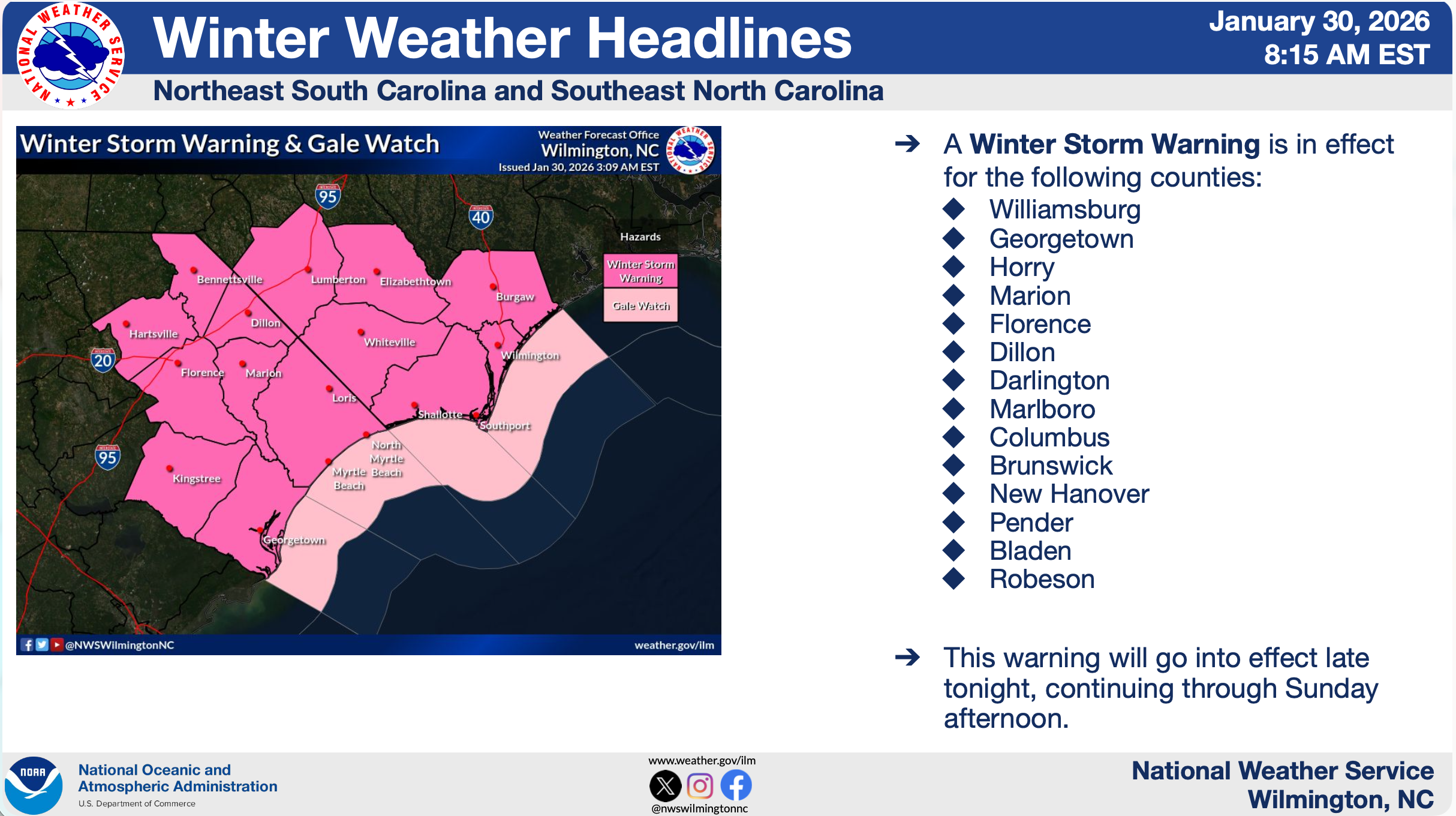
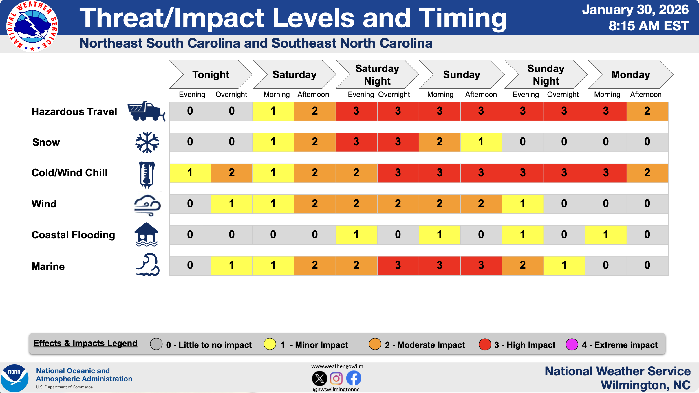
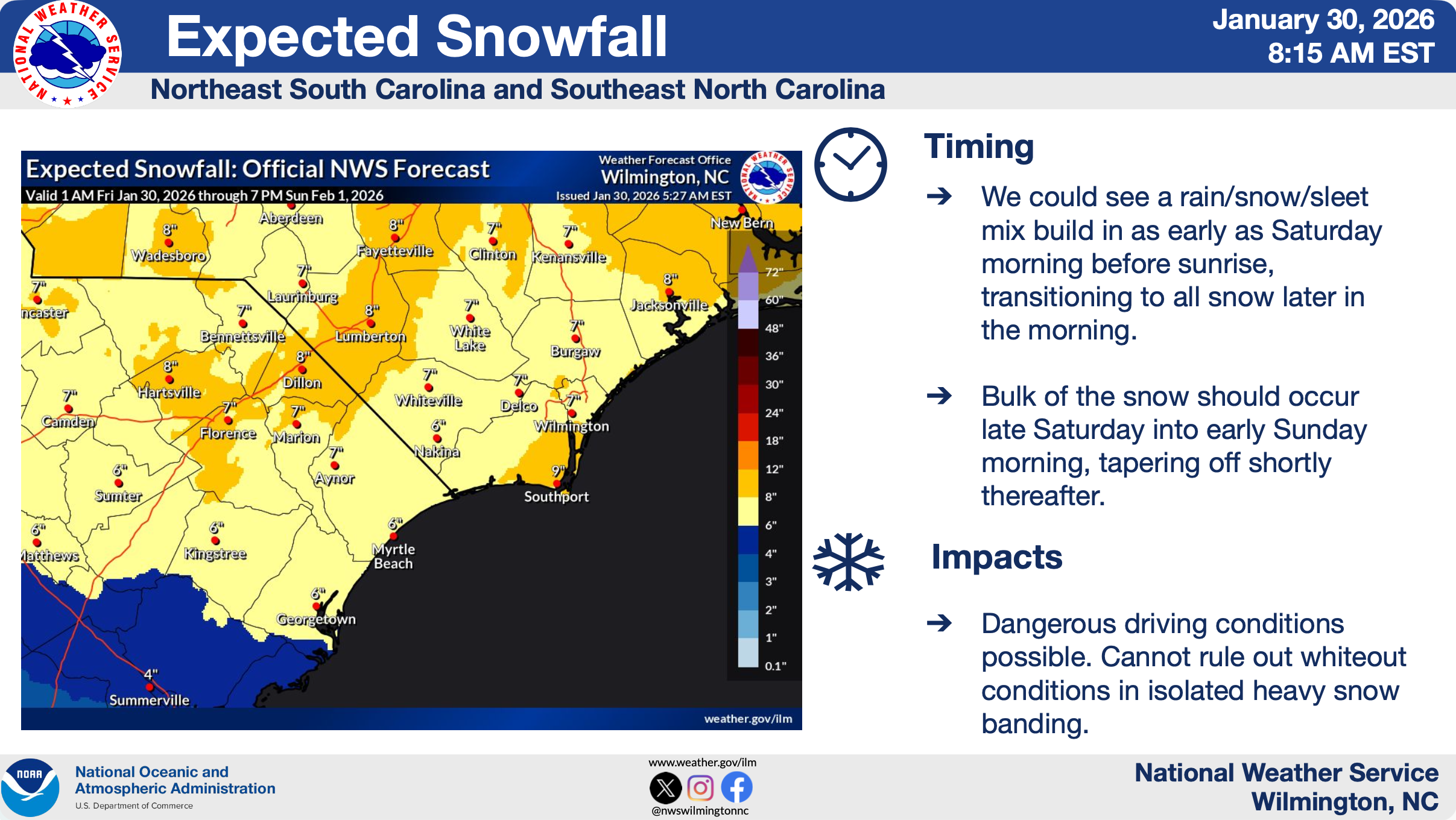
Friday, January 30, 2026, 8:15am
- Important Updates:
- New: Winter Storm Watch has been upgraded to a Winter Storm Warning.
- New: A Cold Weather Advisory has been issued for parts of the area tonight through early Saturday evening. An Extreme Cold Watch remains in effect for early Saturday evening through Monday morning.
- New: Snow onset is trending earlier (Saturday morning)
- High confidence in extremely cold air for the area this weekend, creating significant, rare wind chills
- High confidence in hazardous winds and seas for the coastal waters over the weekend, creating dangerous conditions for mariners
- Increasing confidence for significant snow and associated impacts
- Key Takeaways:
- Confidence is HIGH that the event will occur
- Snow is possible across northeast SC and southeast NC. Heavy snow banding may produce significantly higher local amounts, particularly north of the Cape Fear region.
- Extremely cold temperatures bring wind chills well into the single digits, potentially into the negatives Saturday night.
- Due to expected prolonged cold, hazardous travel conditions could extend through early to middle part of next week.
- Gusty winds may add stress to snow-covered objects.
- Dangerous marine conditions expected across coastal waters, with potential for storm-force wind gusts.

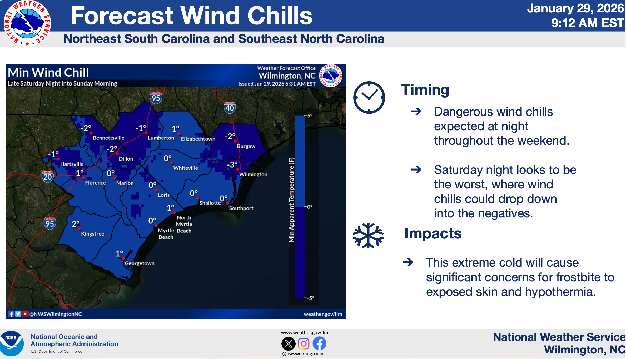
Thursday, January 29, 2026, 3:00pm
- Important Updates:
- New: Extreme Cold Watch has been issued for entire area
- New: Gale Watch has been issued from Surf City, NC to Little River Inlet, SC out 20 nautical miles.
- A Winter Storm Watch remains in effect for the entire area
- Watch will go into effect late Friday, continuing through Sunday afternoon.
- High confidence in extremely cold air for the area this weekend, creating significant, rare wind chills
- High confidence in hazardous winds and seas for the coastal waters over the weekend, creating dangerous conditions for mariners
- Increasing confidence for significant snow and associated impacts
- Key Takeaways:
- Confidence is HIGH that the event will occur
- Snow is possible across northeast SC and southeast NC. Heavy snow banding may produce significantly higher local amounts, particularly north of the Cape Fear region.
- Extremely cold temperatures bring wind chills well into the single digits, potentially into the negatives Saturday night.
- Due to expected prolonged cold, hazardous travel conditions could extend through early to middle part of next week.
- Gusty winds may add stress to snow-covered objects.
- Dangerous marine conditions expected across coastal waters, with potential for storm-force wind gusts.
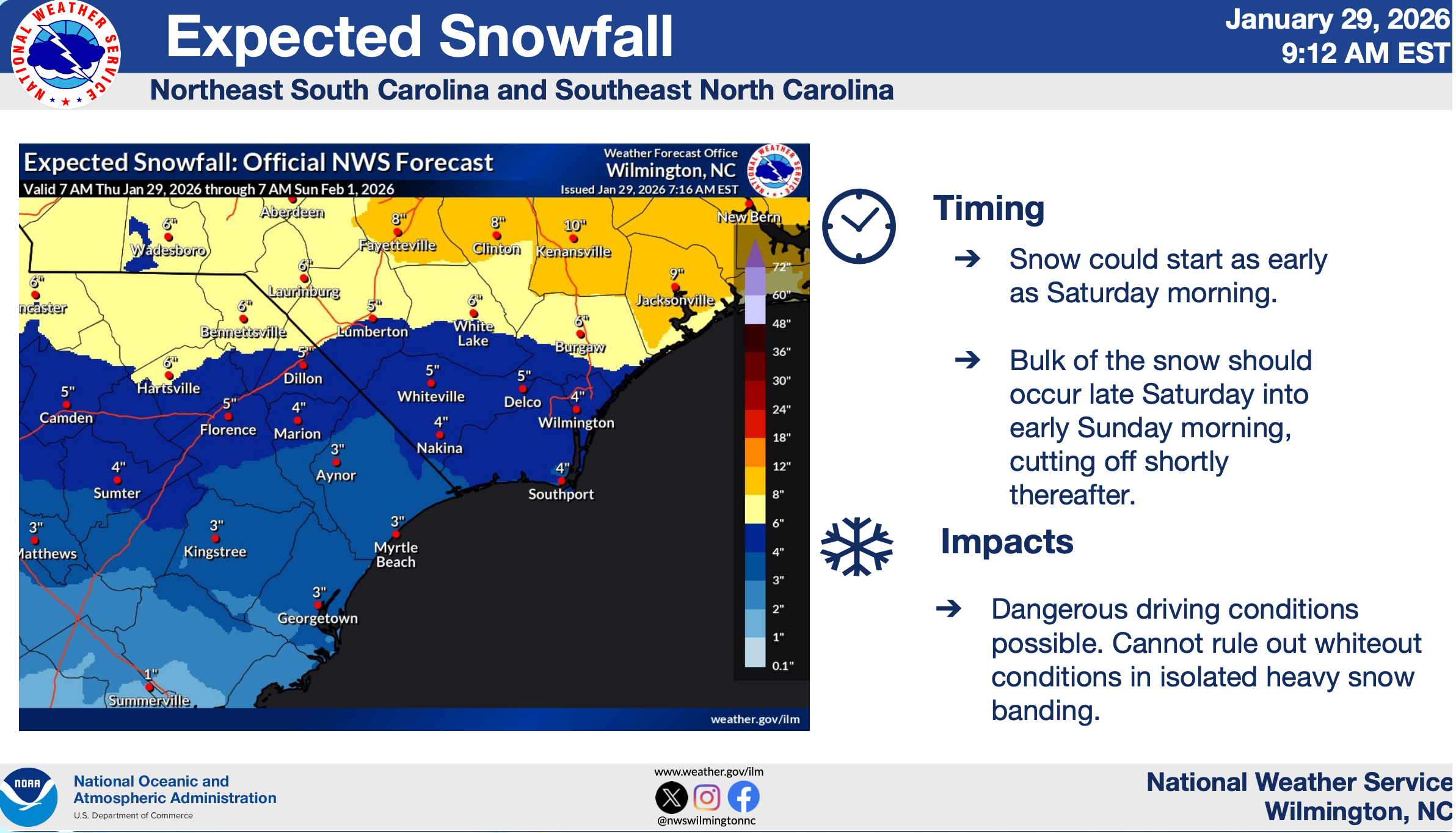
Thursday, January 29, 2026, 9:12am
- Important Updates:
- A Winter Storm Watch has been issued for the entire area
- Watch will go into effect late Friday, continuing through Sunday afternoon.
- High confidence in extremely cold air for the area this weekend, creating significant, rare wind chills
- High confidence in hazardous winds and seas for the coastal waters over the weekend, creating dangerous conditions for mariners
- High confidence of snow for the area, but low confidence on the specific timing, amounts, and impact
- A Winter Storm Watch has been issued for the entire area
- Key Takeaways:
- Confidence is HIGH that the event will occur
- Significant snow is possible across northeast SC and southeast NC. Heavy snow banding may produce significantly higher local amounts, particularly north of the Cape Fear region.
- Extremely cold temperatures bring wind chills well into the single digits, potentially into the negatives Saturday night and Sunday night.
- Due to expected prolonged cold, hazardous travel conditions could extend through early to middle part of next week.
- Strong gusty winds will result in blowing snow, possibly periods of white out conditions, causing poor visibility and reduced traction. Scattered power outages also possible.
- Dangerous marine conditions expected across coastal waters, with potential for storm-force wind gusts.

Wednesday, January 28, 2026, 2:59pm
- Important Updates:
- High confidence in extremely cold air for the area this weekend, creating significant, rare wind chills
- High confidence in hazardous winds and seas for the coastal waters over the weekend, creating dangerous conditions for mariners
- Increasing confidence of snow for the area, but low confidence on the specific timing, amounts, and impact
- Key Takeaways:
- Confidence is HIGH that the event will occur
- Confidence is LOW regarding impacts over land
- Snow is possible across northeast SC and southeast NC. Southeast NC may record the higher amounts.
- Extremely cold temperatures bring wind chills well into the single digits, potentially near 0°F Saturday night.
- Due to expected prolonged cold, hazardous travel conditions could extend through early to middle part of next week.
- Gusty winds may add stress to snow-covered objects.
- Dangerous marine conditions expected across coastal waters, with potential for storm-force wind gusts.
Wednesday, January 28, 2026, 10:16am
- Important Updates:
- High confidence in extremely cold air for the area this weekend, creating significant, rare wind chills
- High confidence in hazardous winds and seas for the coastal waters over the weekend, creating dangerous conditions for mariners
- Increasing confidence of snow for the area, but low confidence on the specific timing, amounts, and impact
- Key Takeaways:
- Confidence is HIGH that the event will occur
- Confidence is LOW regarding impacts over land
- Snow is possible across northeast SC and southeast NC. Southeast NC may record the higher amounts.
- Extremely cold temperatures bring wind chills well into the single digits, potentially near 0°F Saturday night.
- Due to expected prolonged cold, hazardous travel conditions could extend through early to middle part of next week.
- Gusty winds may add stress to snow-covered objects.
- Dangerous marine conditions expected across coastal waters, with potential for storm-force wind gusts.
Winter Storm Fern, January 2026
Questions? Contact NWS Wilmington for 24/7 forecaster assistance.
Sunday, January 25, 2026, 8:10am
- Important Updates:
- Added Coastal Georgetown to Winter Weather Advisory
- Freezing rain could last a bit longer than previously anticipated, especially well inland
- Key Takeaways:
- Confidence is HIGH that the event will occur
- Confidence is HIGH regarding impacts
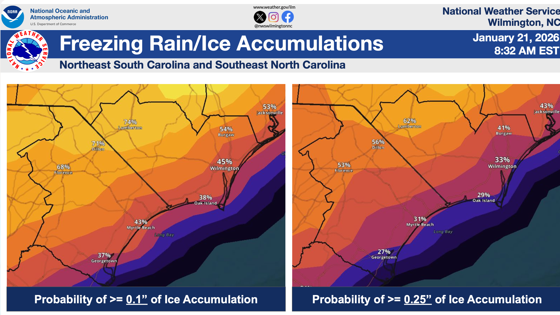
- Ice accumulation up to around 0.25” from freezing rain is expected across southeast NC and northeast SC today, greatest near/west of I-95.
- Dangerous cold temperatures/wind chills will follow through the week which will be especially hazardous to those without power.
- Hazardous marine conditions expected across the coastal waters through Monday night and possibly again late week.
Saturday, January 24, 2026, 3:11pm
- Important Updates:
- No big changes in the forecast, although “high end” ice amounts have come down
- Key Takeaways:
- Confidence is HIGH that the event will occur
- Confidence is HIGH regarding impacts
- Ice accumulation from freezing rain, along with some sleet, is expected across southeast NC and northeast SC, mainly near and west of I-95 and east into Bladen County. Confidence is overall high regarding ice accumulations, though there is still some play regarding the higher amounts west of I-95.
- Dangerous cold temperatures will follow for several days, which will be especially hazardous to those without power.
- Hazardous marine conditions expected across the coastal waters through early next week.
Saturday, January 24, 2026, 11:48am
- Important Updates:
- Ice Storm Warning now in effect for Dillon and Darlington Counties, as well as Marlboro and Robeson Counties
- Winter Weather Advisory in effect for rest of the forecast area (except for coastal Georgetown County)
- Key Takeaways:
- Confidence is HIGH that the event will occur
- Confidence is HIGH regarding impacts
- Ice accumulation from freezing rain, along with some sleet, is expected across southeast NC and northeast SC, mainly near and west of I-95 and east into Bladen County. Confidence is overall high regarding ice accumulations, though there is still some play regarding the higher amounts west of I-95.
- Dangerous cold temperatures will follow for several days, which will be especially hazardous to those without power.
- Hazardous marine conditions expected across the coastal waters through early next week.
Friday, January 23, 2026, 7:15am
- Important Updates:
- No major changes
- Precipitation lingers longer into Sunday night (but as rain, nothing wintry)
- Key Takeaways:
- Confidence is HIGH that the event will occur
- Confidence is LOW regarding impacts
- Ice accretion from freezing rain, along with some sleet, is expected across Southeast NC and Northeast SC, mainly west of I-95 as well as Bladen County. Uncertainty remains, especially for coastal areas, where it could be warmer.
- Dangerous cold temperature will follow, which will prolong any travel impacts and be hazardous to those without power.
- Hazardous marine conditions expected across the coastal waters this weekend.
- The storm will have a large footprint across the Carolina, as well as the Southeast & Mid-Atlantic. Hazardous travel will linger into next week, regardless of local impacts.
Thursday, January 22, 2026, 5:27pm

Thursday, January 22, 2026, 3:45pm
- Important Updates:
- No major changes
- Small Craft Advisory in effect for all waters through this weekend into early next week
- Key Takeaways:
- Confidence is HIGH that the event will occur
- Confidence is LOW regarding impacts
- Ice accretion from freezing rain, along with some sleet, is expected across Southeast NC and Northeast SC, mainly west of I-95 as well as Bladen County. Uncertainty remains, especially for coastal areas, where it could be warmer.
- Dangerous cold temperature will follow, which will prolong any travel impacts and be hazardous to those without power.
- Hazardous marine conditions expected across the coastal waters this weekend.
- The storm will have a large footprint across the Carolina, as well as the Southeast & Mid-Atlantic. Hazardous travel will linger into next week, regardless of local impacts.
Thursday, January 22, 2026, 8:57am
- Important Update: Winter Storm Watch issued for inland counties.
- Key Takeaways:
- Confidence is HIGH that the event will occur
- Confidence is LOW regarding impacts
- Ice accretion from freezing rain, along with some sleet, is expected across Southeast NC and Northeast SC, especially inland areas. Uncertainty remains, especially for coastal areas where it could be warmer.
- Dangerous cold temperatures will follow, which will prolong any travel impacts and be hazardous to those without power.
- Hazardous marine conditions expected across the coastal waters this weekend.
- The storm will have a large footprint across the Carolinas, as well as the Southeast & Mid-Atlantic. Hazardous travel will linger into next week, regardless of local impacts.

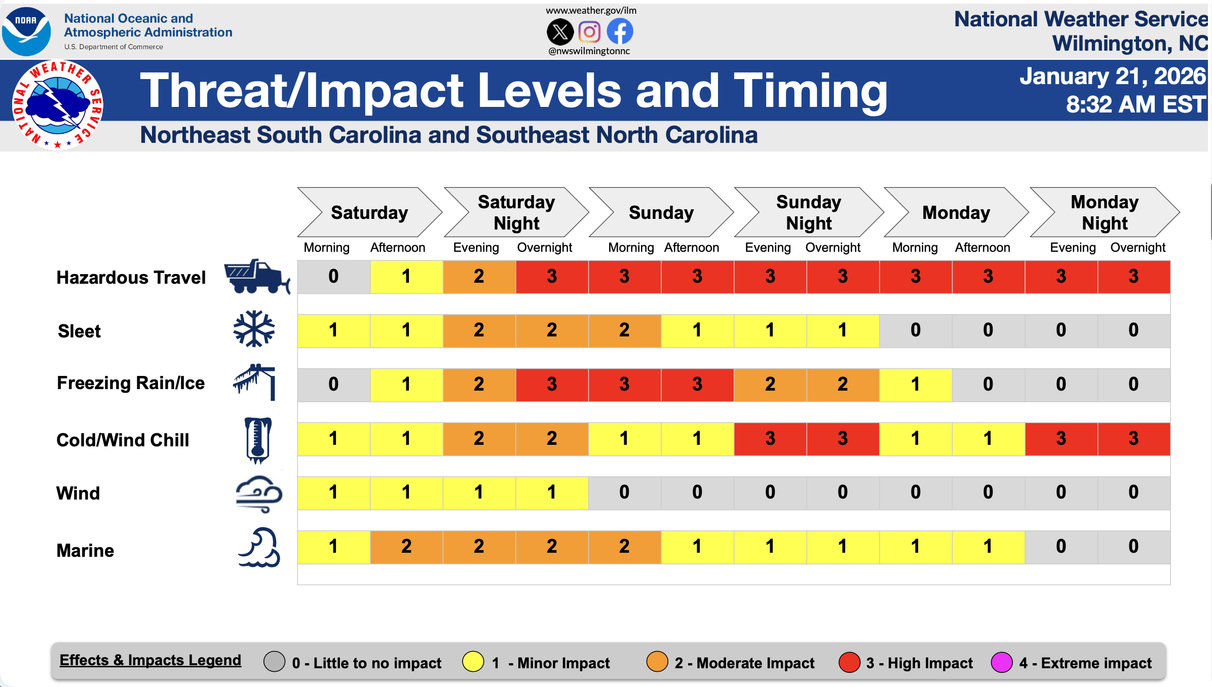
Wednesday, January 21, 2026, 3:23pm
- Important Update: Ice accumulation probabilities have decreased near the coast, but significant ice impacts remain possible.
- Key Takeaways:
- Confidence is HIGH that the event will occur
- Confidence is LOW regarding impacts
- Mixed sleet and ice expected across Southeast NC and Northeast SC, although accumulations remain uncertain.
- Dangerous cold temperatures will follow, which will prolong any travel impacts and be hazardous to those without power.
- Hazardous marine conditions expected across the coastal waters this weekend.
- The storm will have a large footprint across the Carolinas, as well as the Southeast & Mid-Atlantic. Hazardous travel will linger into next week, regardless of local impacts.
Wednesday, January 21, 2026, 10:35am
- Key Takeaways:
- Confidence is HIGH that the event will occur
- Confidence is LOW regarding impacts
- Mixed sleet and ice expected across Southeast NC and Northeast SC, although accumulations remain uncertain.
- Dangerous cold temperatures will follow, which will prolong any travel impacts and be hazardous to those without power.
- Hazardous marine conditions expected across the coastal waters this weekend.
- The storm will have a large footprint across the Carolinas, as well as the Southeast & Mid-Atlantic. Hazardous travel will linger into next week, regardless of local impacts.
Tropical Storm Imeda, September 2025
Questions? Contact NWS Wilmington for 24/7 forecaster assistance.
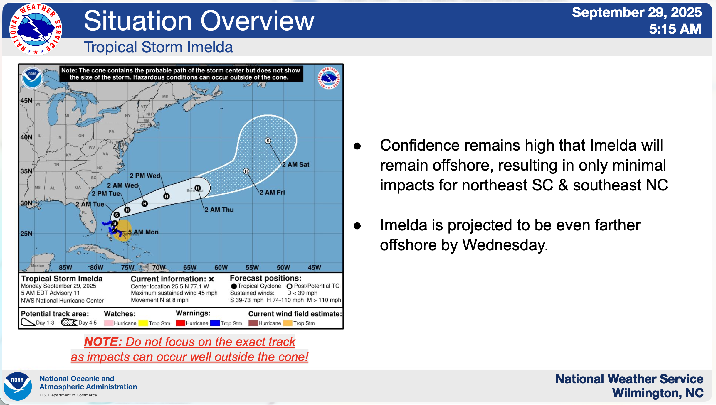
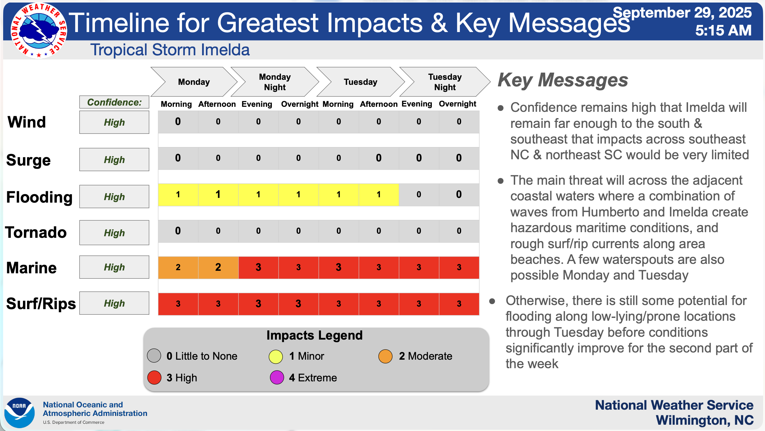
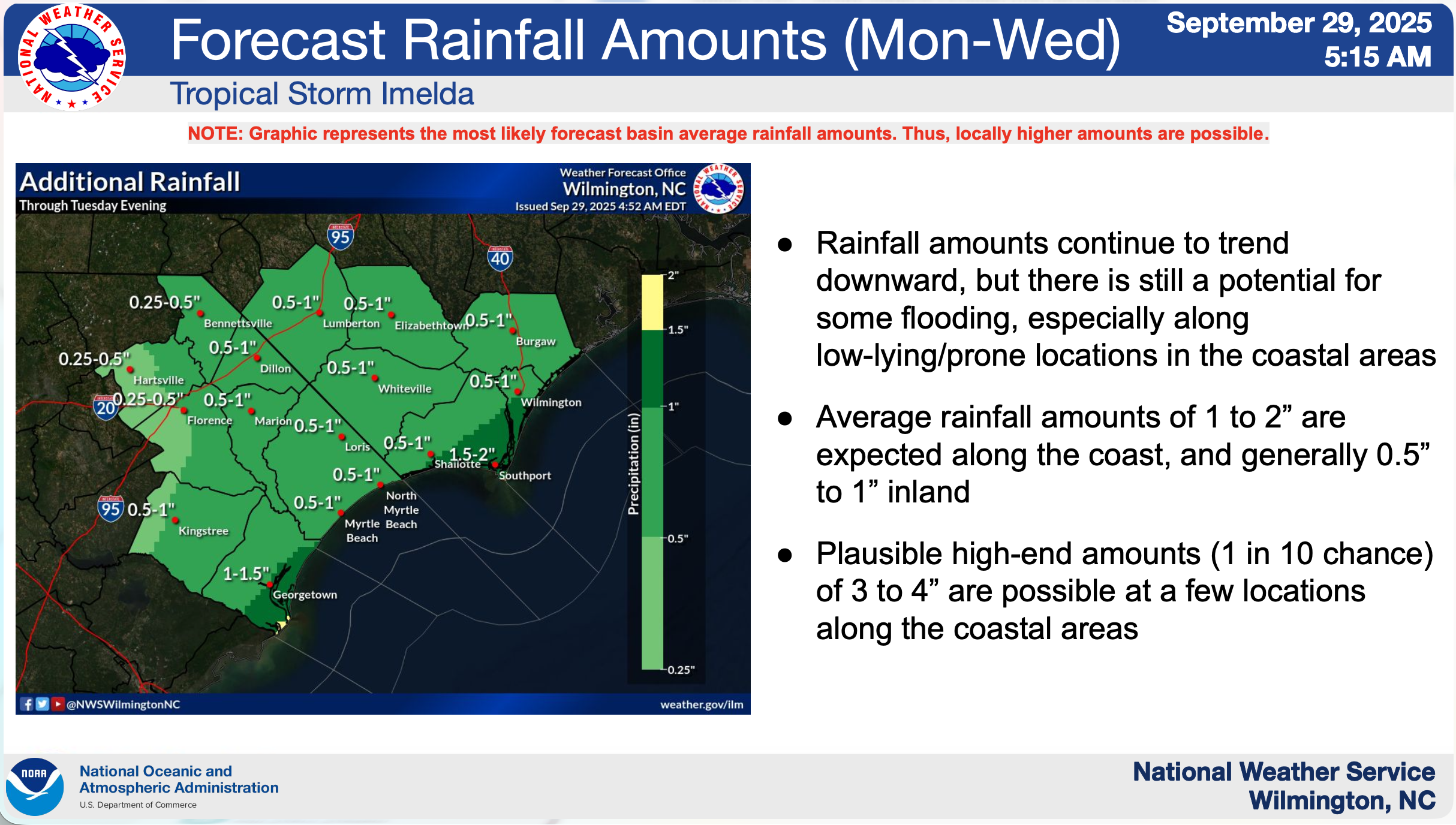
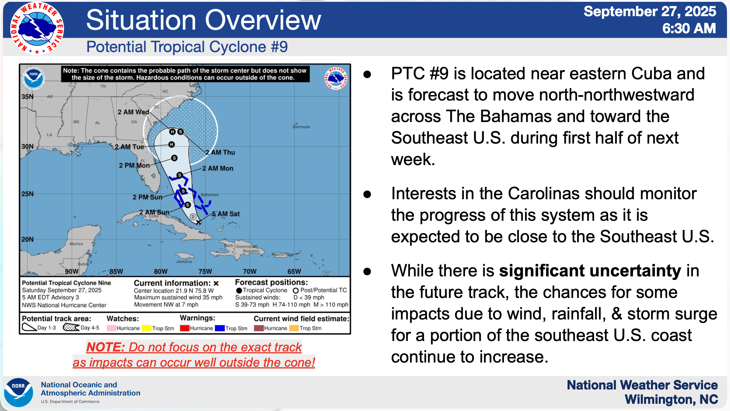
Monday, September 29, 2025, 11:29am, Final Update
Confidence is high regarding the storm track/timing/intensity of Tropical Storm Imelda. Confidence is high regarding all impacts.
-
Tropical storm force wind gusts are not likely across land areas, as the strongest winds will remain off the coast.
-
Storm surge flooding directly from Imelda is not expected but minor coastal flooding could still occur mid to late week due to strong/persistent northeast winds. Some beach erosion is also possible.
-
Rainfall flooding is possible for a few areas, Monday through Tuesday, mainly in low-lying and poor drainage areas near the coast.
-
Tornadoes are unlikely, although waterspouts are possible Monday through Tuesday across the adjacent Atlantic waters.
-
Hazardous marine/surf conditions with strong rip currents are expected Monday through Saturday from a combination of swells from Imelda and Humberto.
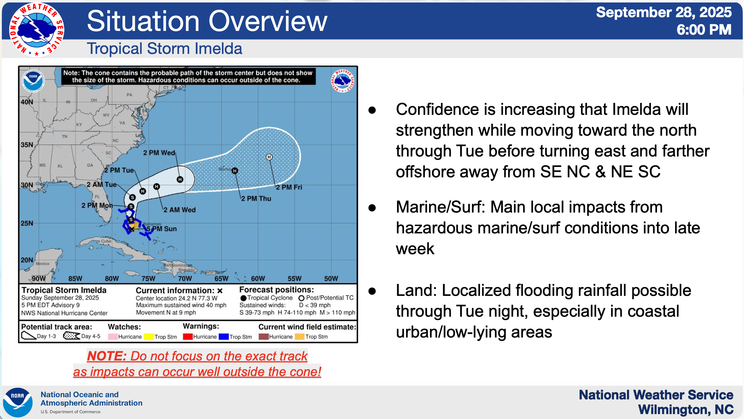
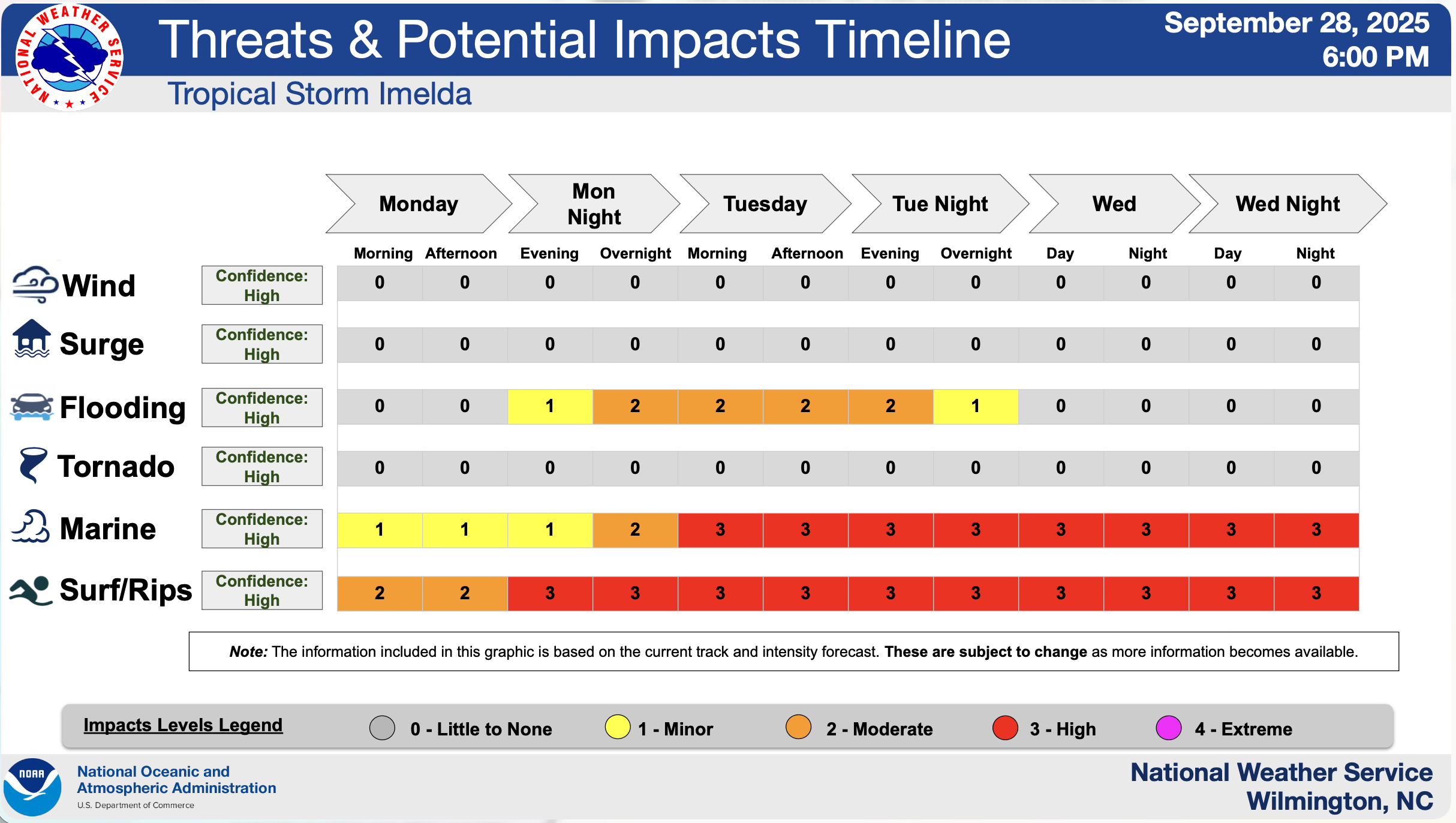
Sunday, September 28, 2025, 9:05pm
Confidence is increasing regarding the storm track/timing/intensity of Tropical Storm Imelda. Confidence is high regarding all impacts.
-
Tropical storm force wind gusts are possible, especially along the NE SC coast and far southern NC coast, although downed trees/power lines and power outages are unlikely.
-
Storm surge flooding directly from Imelda is not expected but minor coastal flooding could still occur mid to late week due to strong/persistent northeast winds. Some beach erosion is also possible.
-
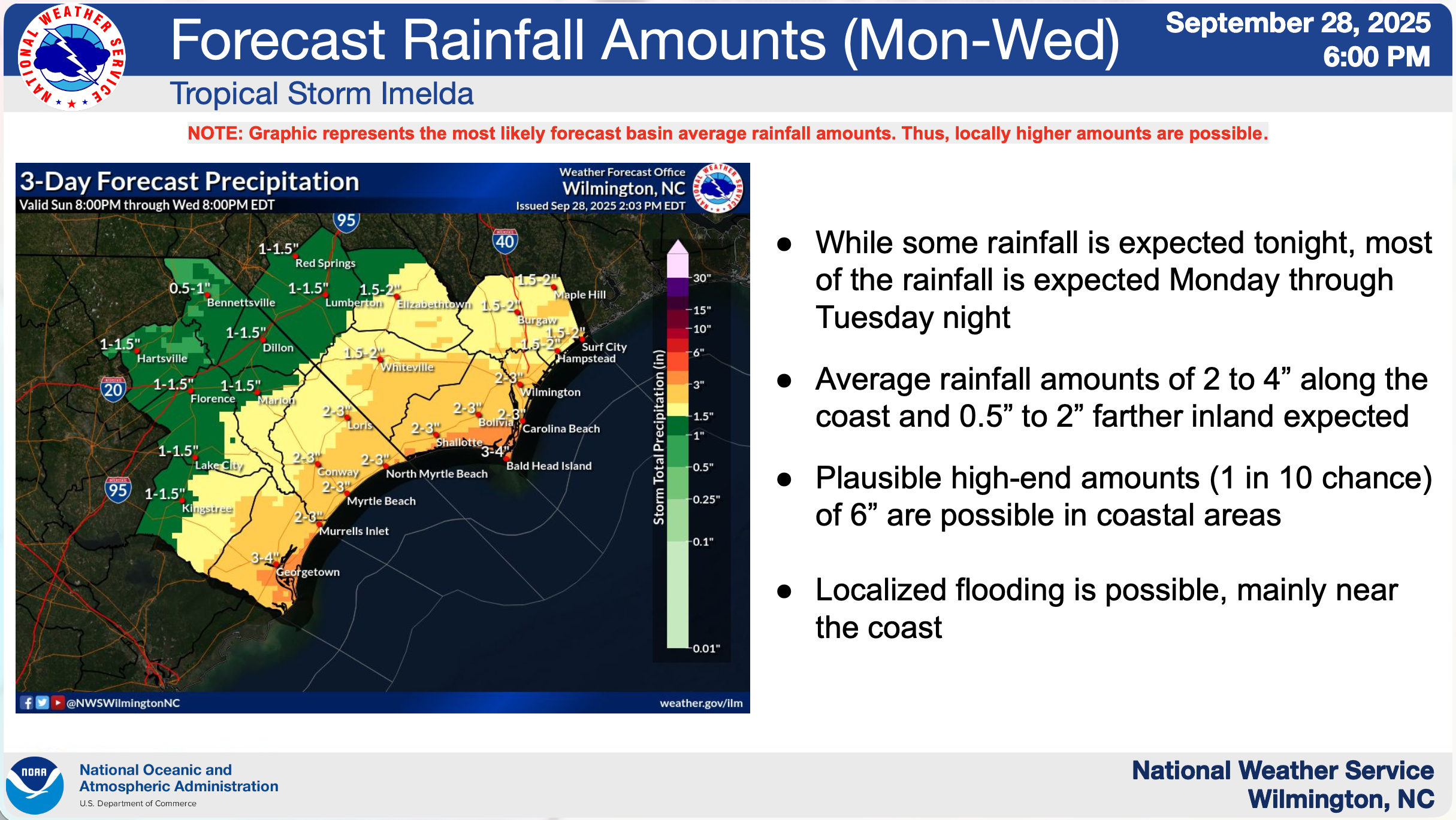
Rainfall flooding is possible, especially Mon through Tue night, mainly in low-lying and poor drainage areas near the coast.
-
Tornadoes are unlikely, although waterspouts are possible Mon through Tue across the adjacent Atlantic waters.
-
Dangerous marine/surf conditions are expected to develop by Mon night and Tue, along with strong rip currents through most of next week. Swells from Humberto will also add to the hazardous maritime/beach conditions that will persist through much of the week.
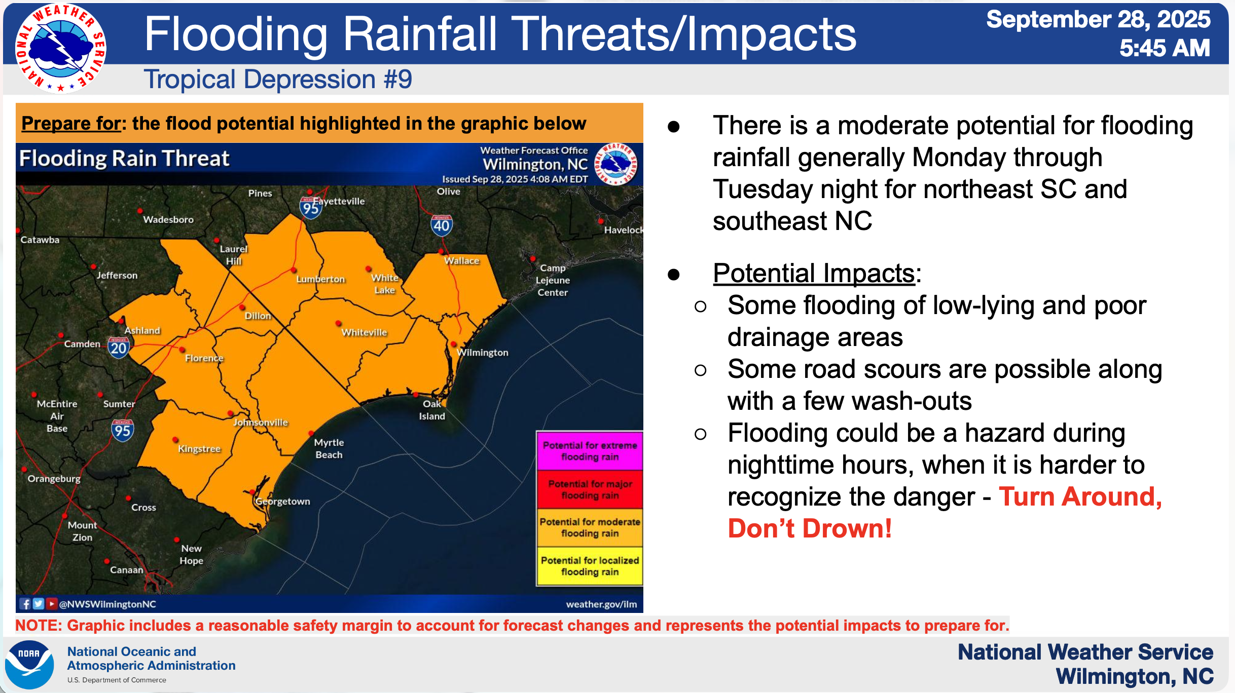
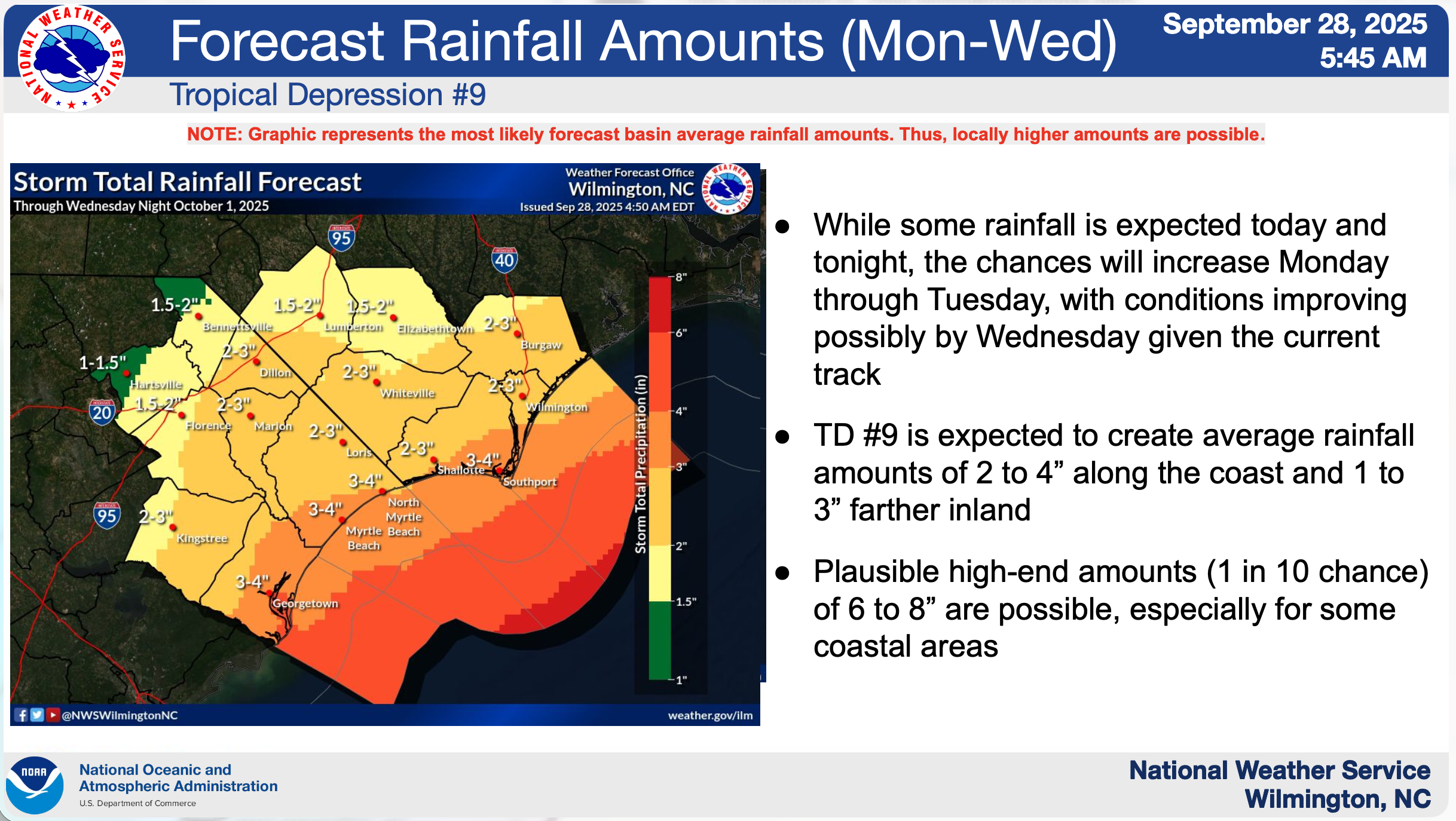
Sunday, September 28, 2025, 4:48pm
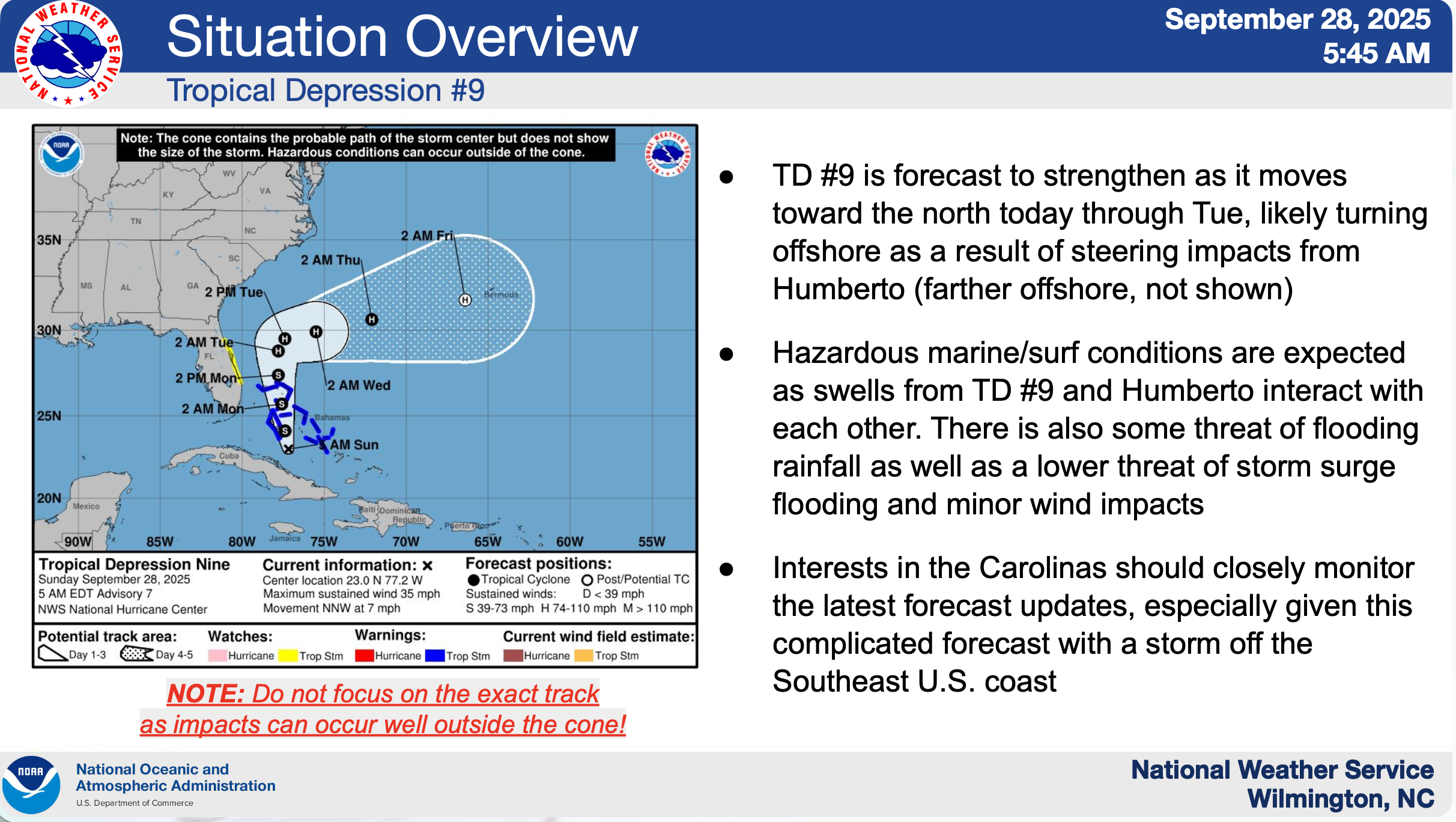
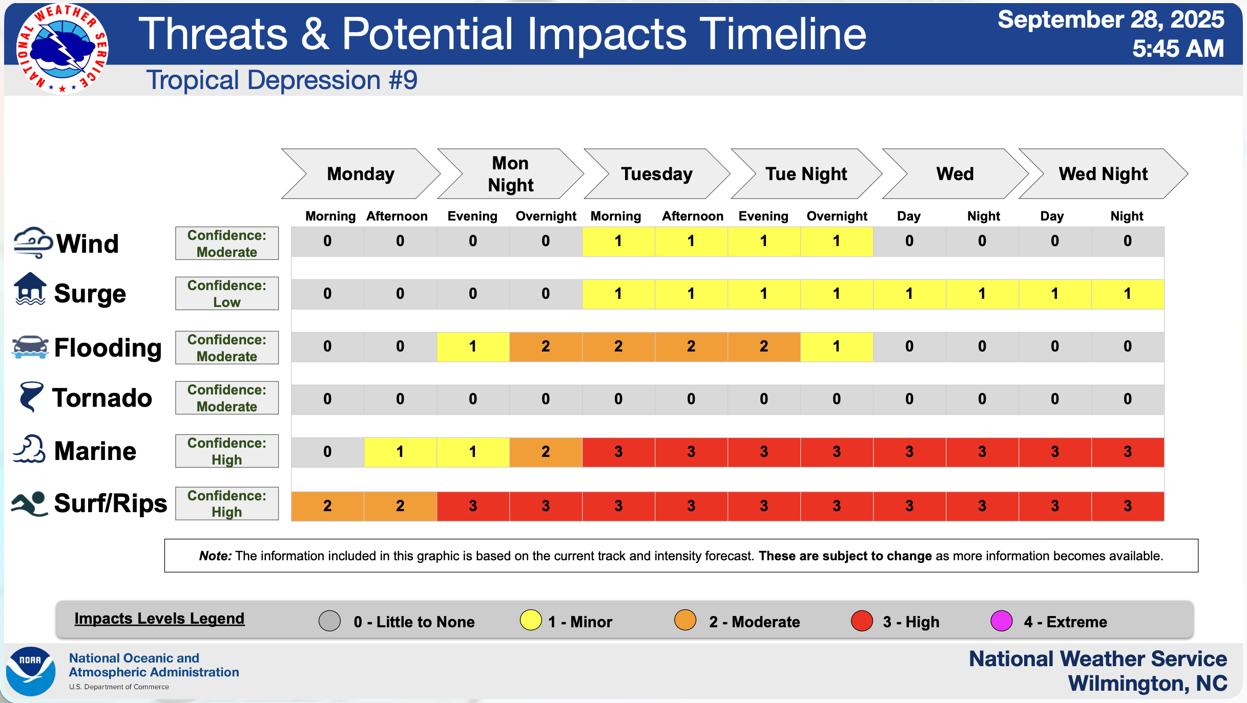
Overall, confidence is moderate is high regarding marine/surf impacts, moderate at this time regarding the track/timing/intensity of Tropical Depression #9. Confidence is high regarding marine/surf impacts, moderate for wind, flooding rainfall, & tornadoes, and low for surge.
-
While the risk for tropical storm force winds has decreased given the latest forecast, there is still some potential for tropical storm force winds Tue, especially along the northeast SC coast. The strongest winds are currently expected to remain offshore unless the track changes.
-
Minor storm surge flooding and some beach erosion is possible for coastal areas Tue and Wed. Coastal flooding could linger into late week, given persistent northeasterly flow along the coast.
-
Rainfall flooding is possible, especially Mon Night through Tue night, especially for coastal low-lying and poor drainage areas.
-
The risk for tornadoes has decreased given an offshore track, however waterspouts are possible across the adjacent Atlantic waters, especially Tue.
-
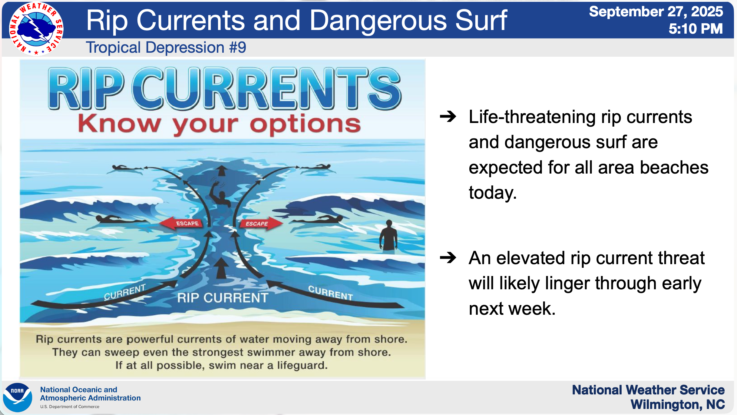
Dangerous marine/surf conditions are expected to develop by Mon night and Tue, along with strong rip currents through most of next week. Swells from Humberto will also add to the hazardous maritime/beach conditions that will persist through much of the week.
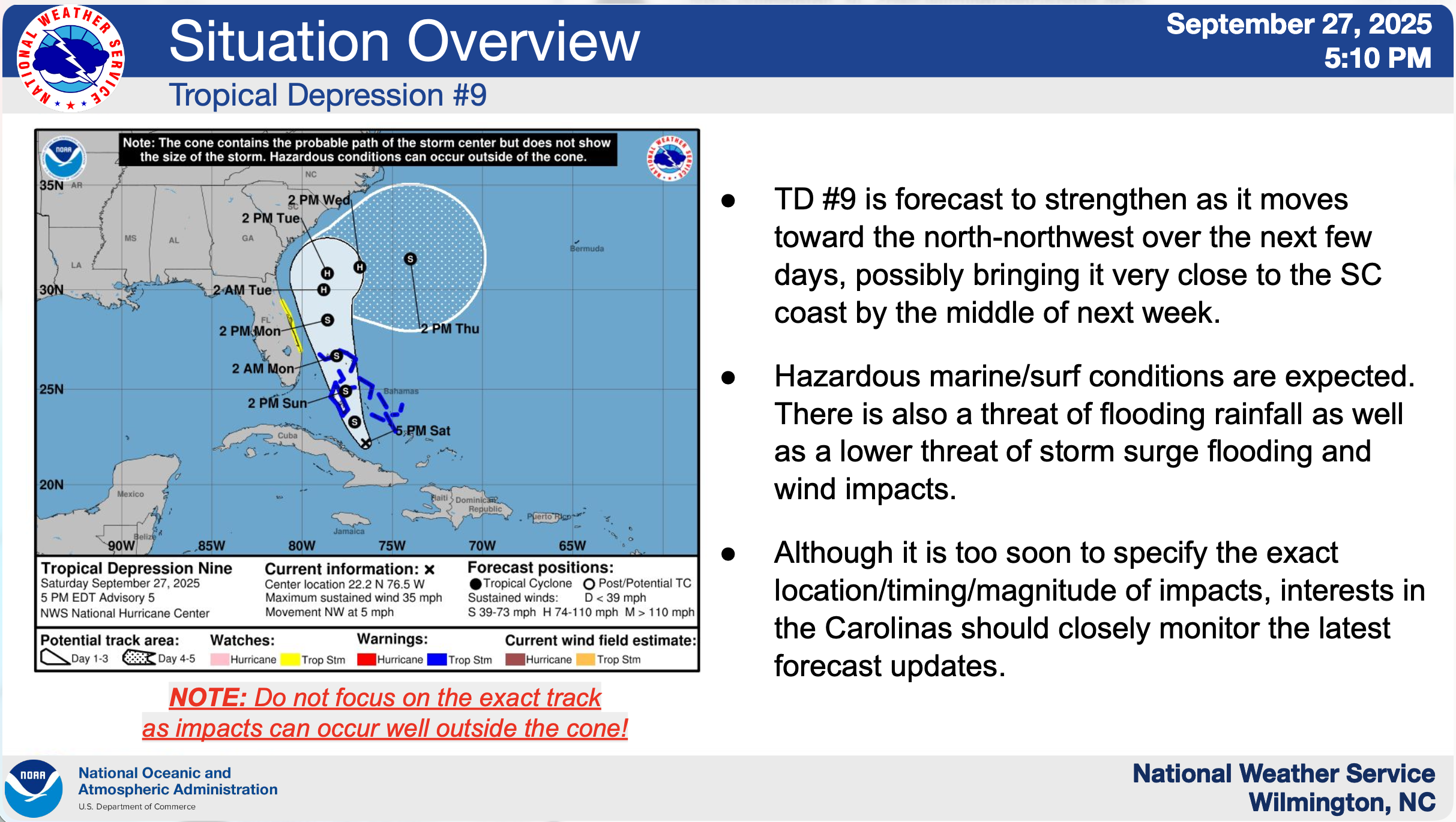
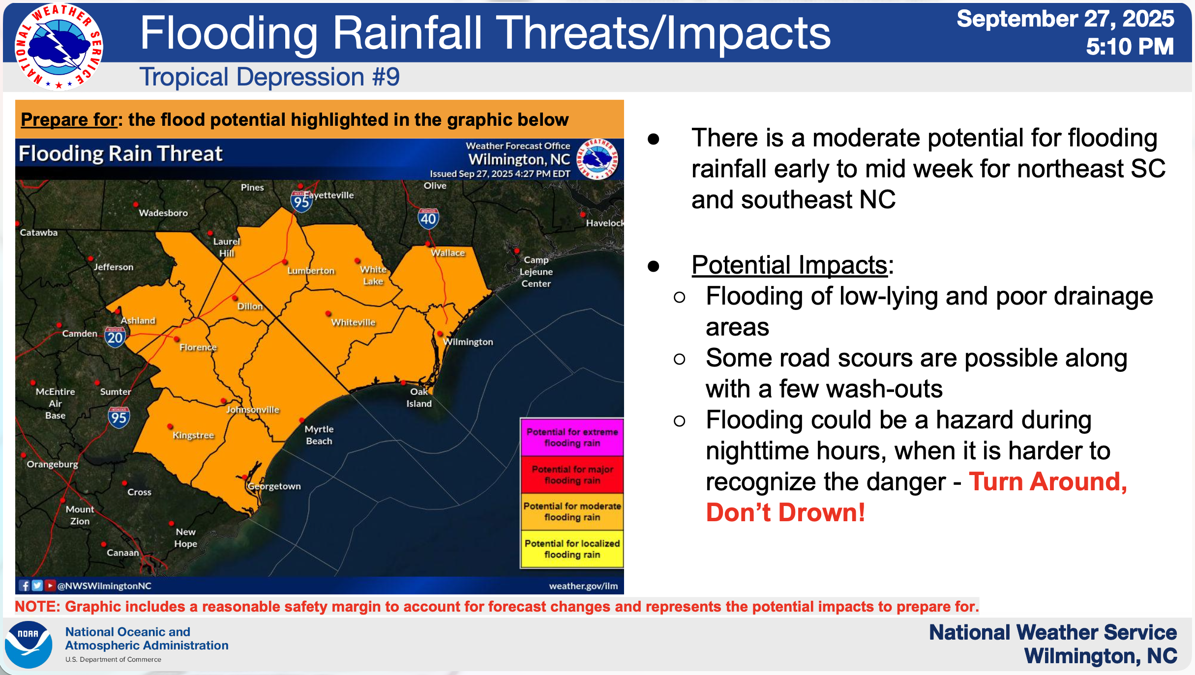
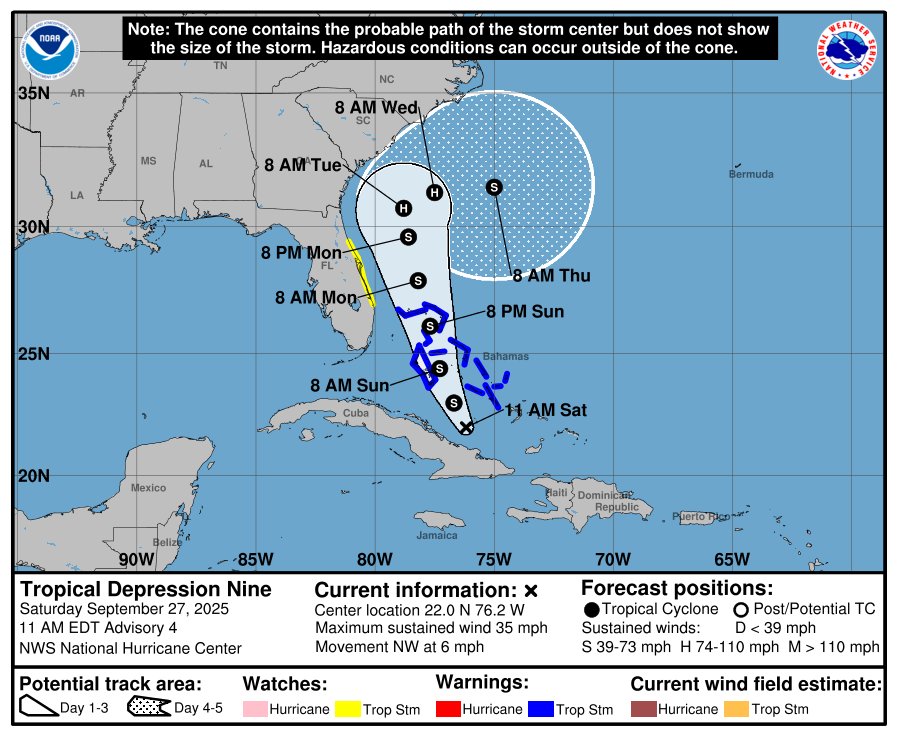
Saturday, September 27, 2025, 8:20pm
Overall, confidence remains low at this time regarding the track/timing/intensity of Tropical Depression #9. Confidence is high regarding marine/surf impacts and moderate for flooding rainfall.
-
Tropical storm force winds are possible for some coastal areas, especially along the northeast SC coast. The strongest winds are currently expected to remain offshore unless the track change. These winds could cause power outages and downed trees/limbs.
-
Storm surge flooding and significant beach erosion is possible for some coastal areas of the Carolinas early to mid week. Coastal flooding could linger into late week.
-
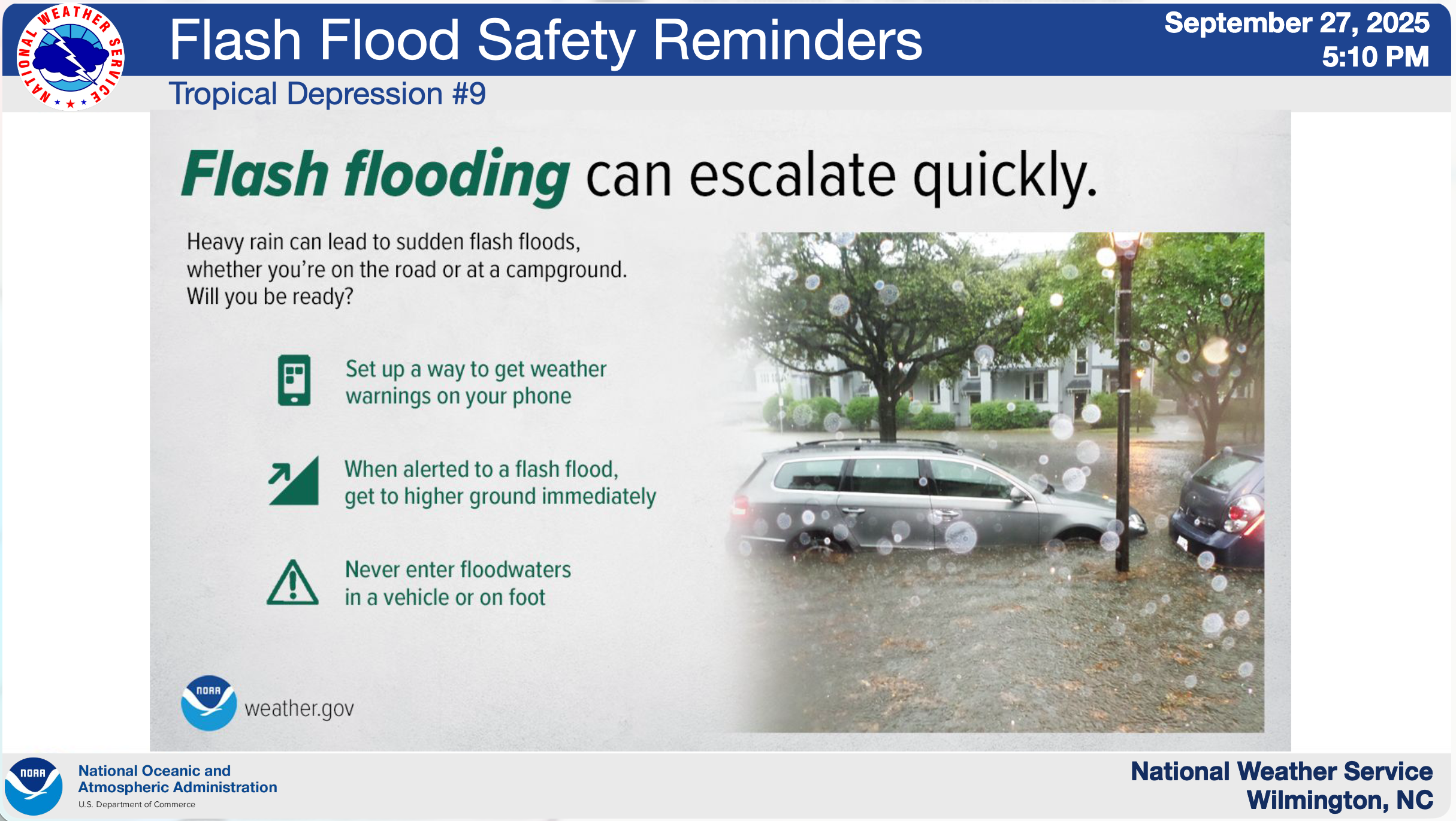
Flooding from heavy rainfall is likely early next week, especially across low-lying and poor drainage areas, with the heaviest rainfall expected early to mid week.
-
There may be a risk of isolated tornadoes between Monday night and Wednesday, mainly across coastal areas of southeast North Carolina and northeast South Carolina.
-
Dangerous marine/surf conditions are expected to develop on Monday, along with strong rip currents through most of next week. Swells from Humberto will also add to the hazardous maritime/beach conditions.

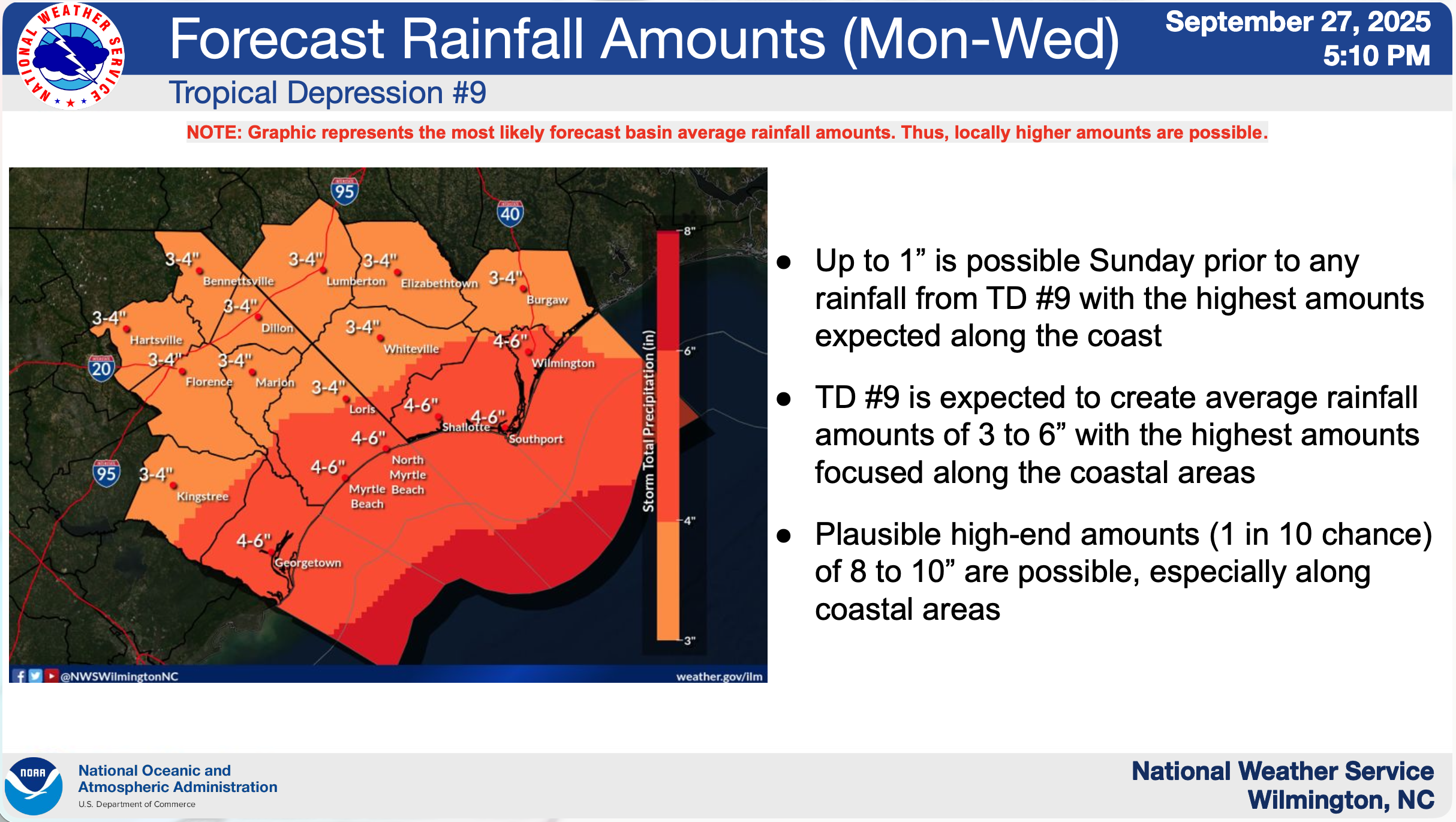
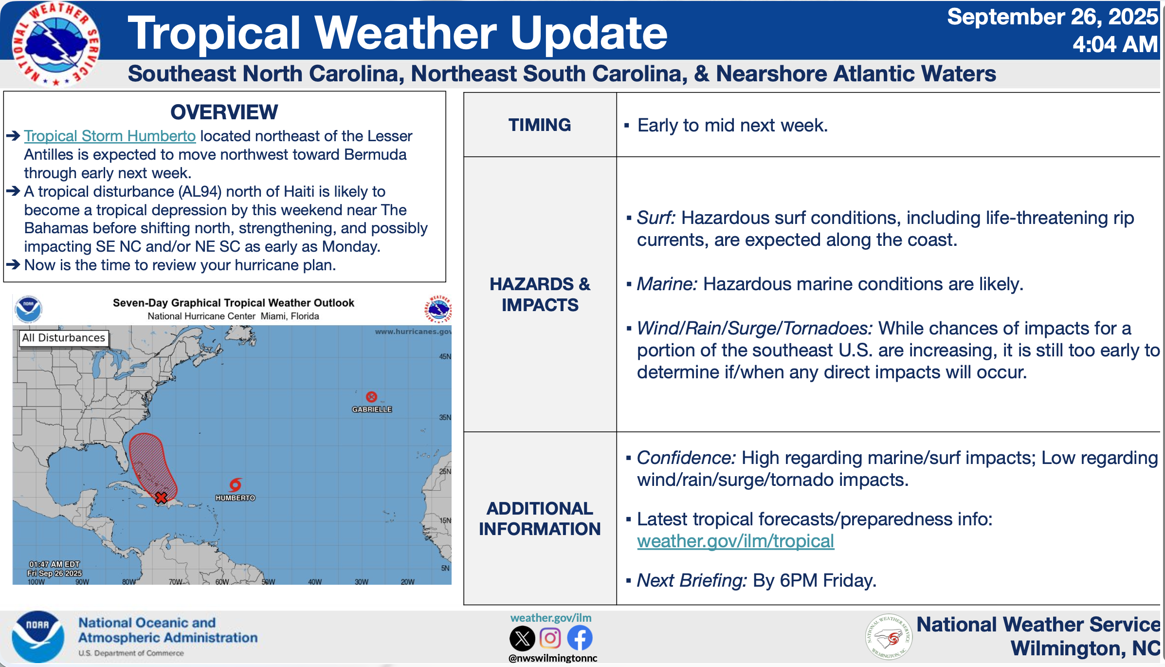
Saturday, September 27, 2025, 3:11pm
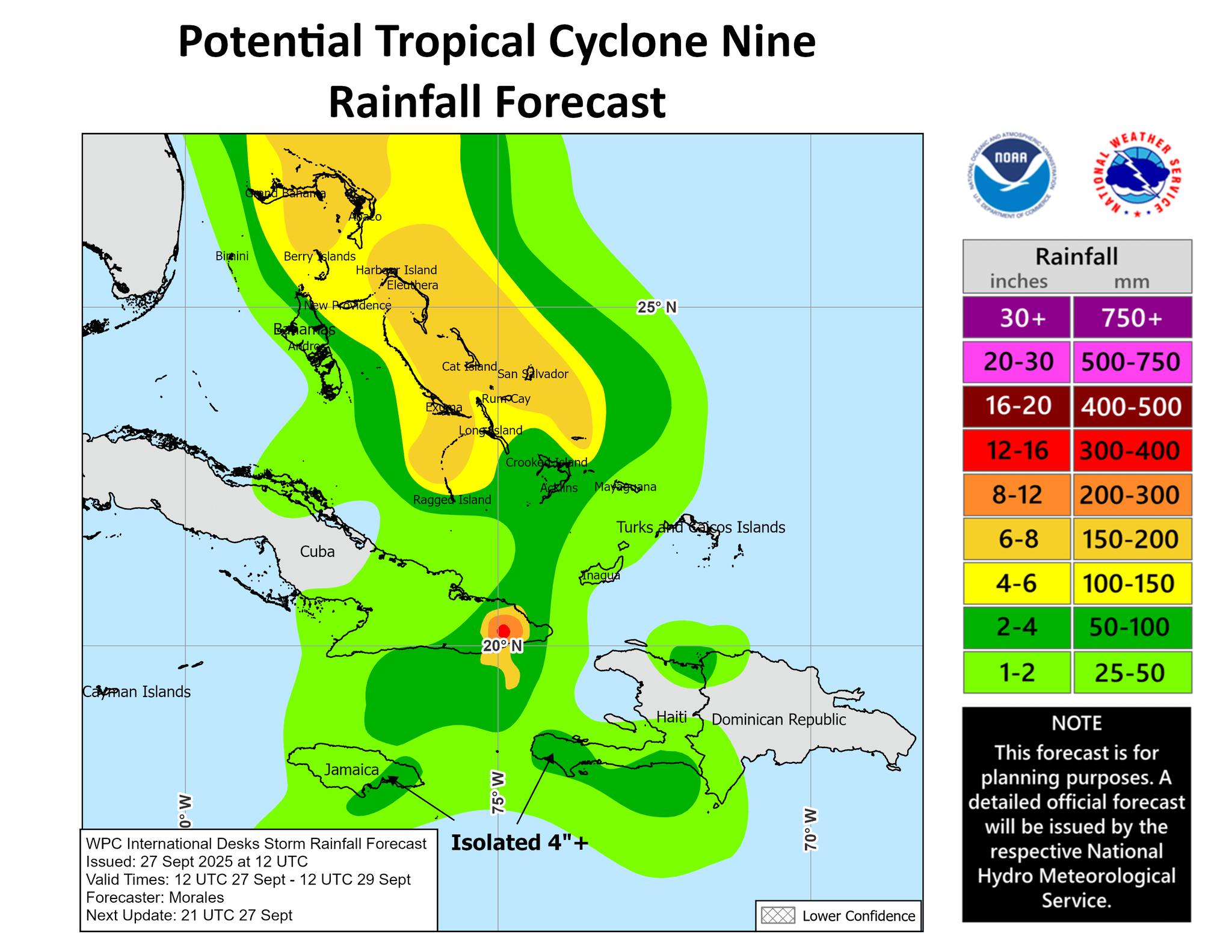
- Tropical depression Nine is expected to strengthen and bring tropical storm conditions to portions of the central and northwestern Bahamas through Sunday night. Tropical storm conditions are also possible along portions of the east coast of central Florida beginning Monday, where a Tropical Storm Watch has been issued.
- Rainfall associated with this system will continue to impact eastern Cuba, Hispaniola, Jamaica, and the Bahamas through the weekend, which will likely produce flash and urban flooding. Mudslides are possible in the higher terrain.
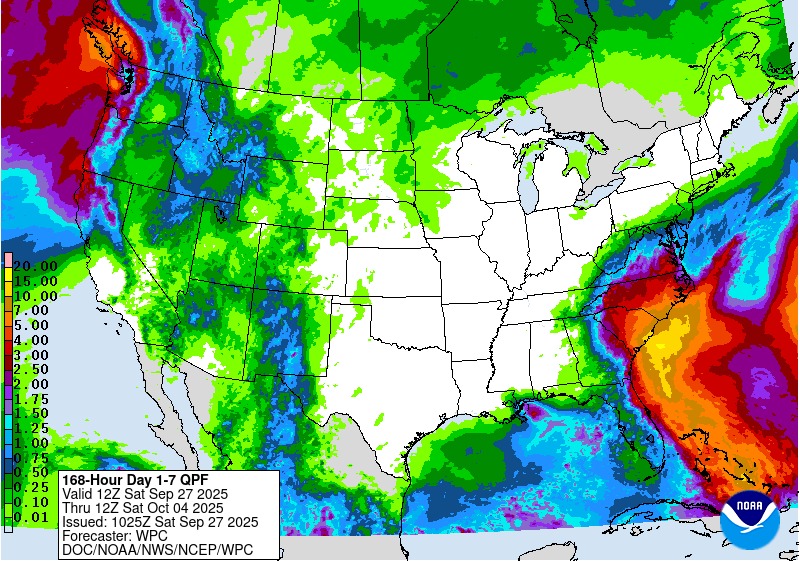
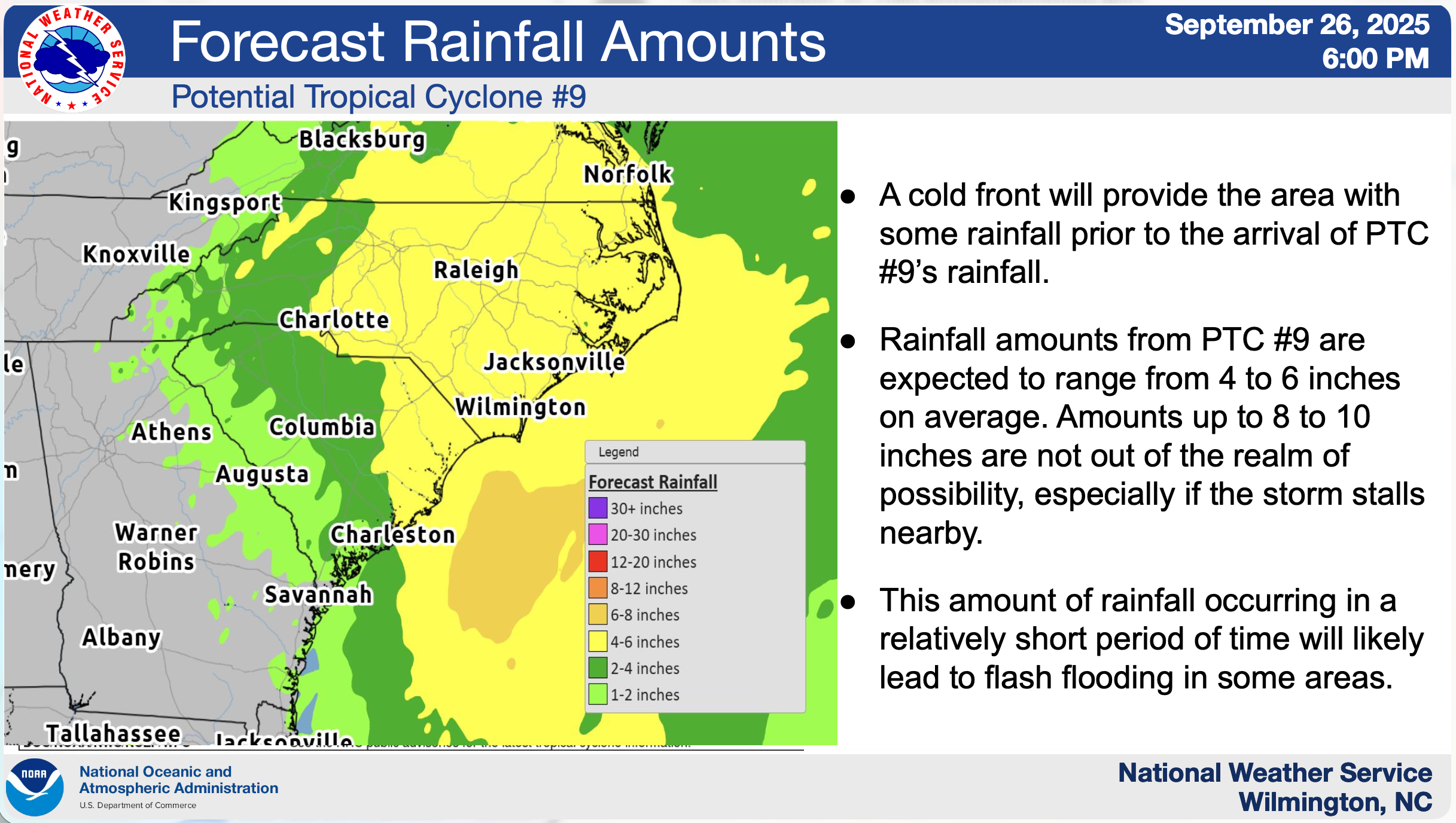
- There is a significant threat of heavy rainfall early next week from coastal Georgia through the Carolinas and into the southern Mid-Atlantic states, which could cause flash, urban, and river flooding.
- The depression is expected to be at or near hurricane intensity when it approaches the southeast U.S. coast early next week, where there is a risk of storm surge and wind impacts. Although it is too soon to specify the exact location and magnitude of impacts, residents should closely monitor the latest forecast updates and ensure that they have their hurricane plan in place.
Saturday, September 27, 2025, 8:53am
Overall, confidence remains low at this time regarding the track/timing/intensity of this weather system. Confidence is high regarding marine/surf impacts, and moderate for heavy rainfall/flooding.
-
Winds to tropical storm force are possible, and hurricane force winds are not out of the question for portions of the Carolinas early next week. These winds could cause power outages and downed trees/limbs.
-
Storm surge flooding and significant beach erosion is possible for some Carolinas early next week.
-
Flooding from heavy rainfall is likely early next week, especially across low-lying and poor drainage areas, with the heaviest rainfall expected between Monday night and Tuesday night, possibly lasting into late week.
-
There may be a risk of tornadoes, especially Monday night and Tuesday across portions of southeast North Carolina and northeast South Carolina.
-
Dangerous marine/surf conditions are expected to develop Monday, along with strong rip currents through at least first half of next week. Swells from Humberto will also add to the hazardous maritime and beach conditions.


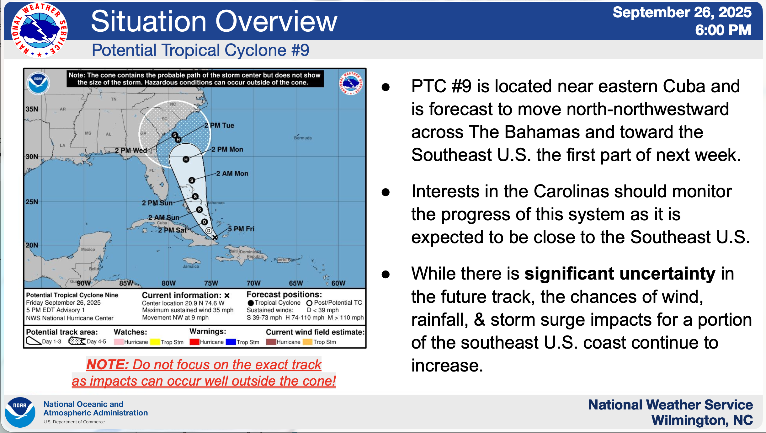
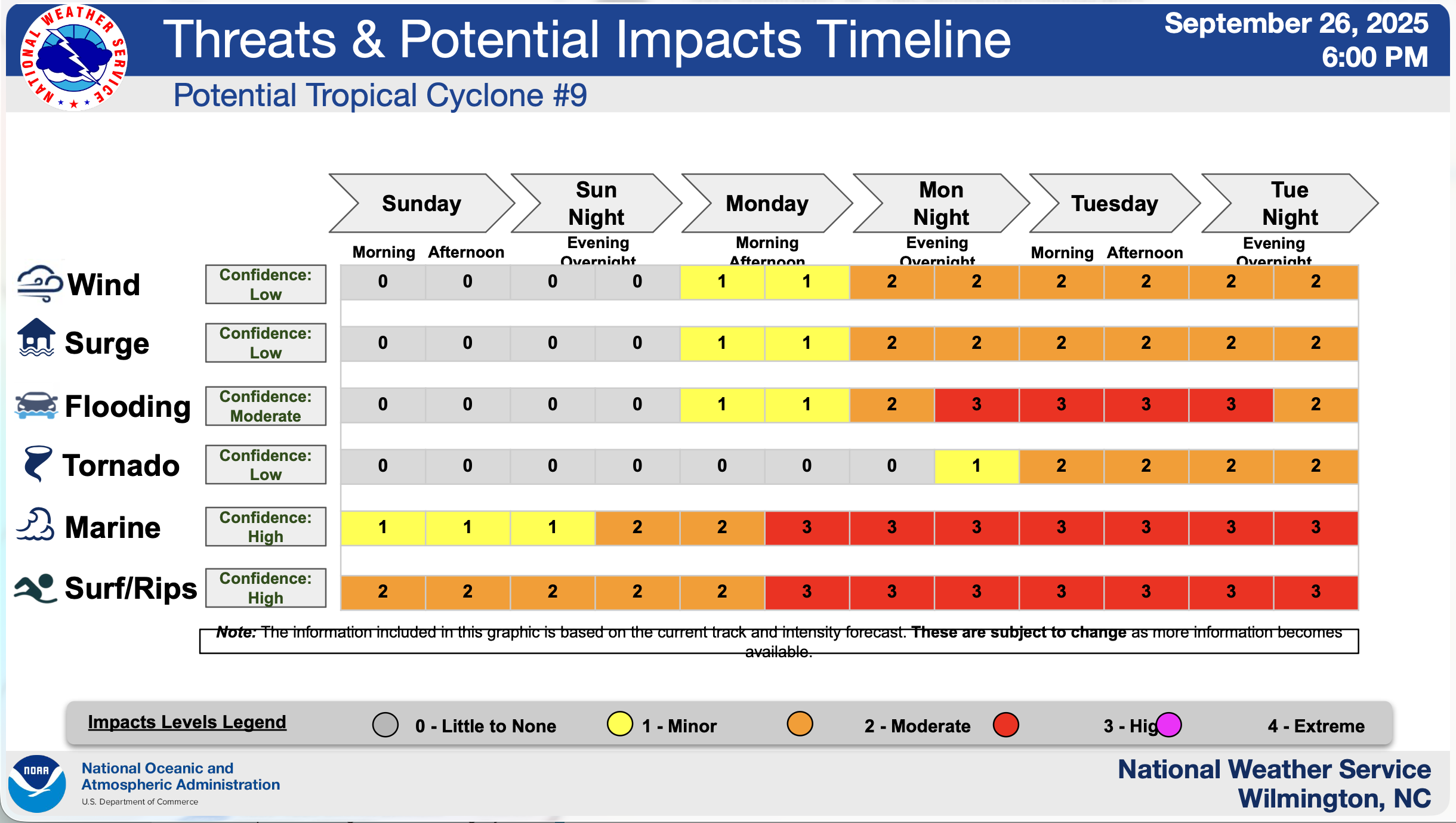
Friday, September 26, 2025, 10:00pm
Overall, confidence remains low at this time regarding the track/intensity of this weather system. Confidence is high regarding marine/surf impacts, and moderate for heavy rainfall/flooding.
-
Winds to tropical storm force are possible, and hurricane force winds are not out of the question for portions of the Carolinas early next week. These winds could cause power outages and downed trees/limbs.
-
Storm surge flooding and significant beach erosion is possible for some Carolinas early next week.
-
Flooding from heavy rainfall is likely early next week, especially across prone and low-lying areas with the heaviest rainfall expected Monday through Tuesday, possibly through late week.
-
There may be a risk of tornadoes, especially Monday night into Tuesday across portions of southeast North Carolina and northeast South Carolina.
-
Dangerous marine/surf conditions are expected to develop Monday, along with strong rip currents through at least first half of next week. Swells from Humberto will also add to the hazardous maritime and beach conditions.

Friday, September 26, 2025, 11:00am
Tropical Storm Chantal, July 2025
Questions? Contact NWS Wilmington for 24/7 forecaster assistance.
Sunday, July 6, 2025, 12:01pm, Final Update
- All Tropical Storm Warnings have been cancelled.
- Strong rip currents and dangerous surf will continue for all area beaches today.
- Hazardous surf conditions may continue through early next week.
- Hazardous marine conditions continue as well.
- High Risk of Rip Currents (Rip Currents Statement) in effect for all area beaches through this evening.
- A High Surf Advisory (for waves at or greater than 6 feet) continues for the northeastern SC coastline and the Brunswick County coastline through this evening.
- A Small Craft Advisory is now in effect through this evening for all of our area’s nearshore waters out 20 nm.
Sunday, July 6, 2025, 5:33am
Confidence is MODERATE to HIGH regarding potential impacts
Key Messages
- Winds to tropical storm force are expected, especially along coastal areas today. These winds could cause some power outages and downed trees/limbs.
- Flooding from heavy rainfall is possible, especially across some prone and low-lying areas with the heaviest rainfall occurring through late this afternoon.
- There is a marginal risk of tornadoes across southeast North Carolina and portions of northeast South Carolina today.
- Dangerous marine/surf conditions are expected, along with strong rip currents through Sunday.


Saturday July 5, 2025, 5:04pm
Highlights
- Chantal will approach the SC coast this evening, possibly making landfall during the early morning hours Sunday.
- Chantal will bring a variety of impacts to northeast SC and southeast NC, with the potential for flash flooding from heavy rainfall, especially tonight into Sunday.
- Otherwise, a marginal risk for tornadoes exists for tonight along the coastal areas, and all of southeast NC and portions of northeast SC during Sunday.
- Strong rip currents, rough surf, and hazardous boating conditions will persist through Sunday.
Key Takeaways
- Winds to tropical storm force are possible, especially along coastal areas tonight into Sunday. These winds could cause some power outages and downed trees/limbs.
- Storm surge flooding of 1-2’ inundation above ground level is possible, especially with high tide late tonight and Sunday afternoon.
- Flooding from heavy rainfall is possible, especially across some prone and low-lying areas with the heaviest rainfall occurring tonight through Sunday.
- There is a marginal risk of tornadoes, with the greatest threat across coastal areas of northeast SC & southeast NC tonight, and all of southeast NC and portions of northeast SC during Sunday.
- Dangerous marine/surf conditions are expected, along with strong rip currents through Sunday.
Forecast Confidence: Moderate to High


Saturday, July 5, 2025, 11:57am
- Coastal New Hanover and Coastal Pender
- Inland Georgetown and Central Horry
- Nearshore waters from Cape Fear to Surf City out 20 nm
- Rainfall flooding is expected, especially across some prone and low-lying areas with the heaviest rainfall occurring tonight into Sunday.
- Dangerous marine/surf conditions are expected, along with strong rip currents.
Saturday, July 5, 2025, 9:28am
Questions? Contact NWS Wilmington for 24/7 forecaster assistance.
Highlights
- Chantal will drift towards the SC coast late tonight and it will bring a few hazards to the area including, high surf/rip currents, rough maritime conditions, and heavy rainfall/potential for flash flooding.
- Tropical storm force winds may impact portions of northeast SC starting late tonight into Sunday causing some downed trees and some power outages.
- Heavy rainfall, especially tonight into Sunday will likely result in some flooding, especially along prone and low-lying areas.
- Rough surf and strong rip currents are expected today into early next week.
Key Takeaways
- Winds to tropical storm force are possible, especially along portions of Long Bay tonight into Sunday. These winds could cause some power outages and downed trees/limbs.
- Storm surge flooding of 1-3’ inundation above ground level is possible, especially along Long Bay (Brunswick, Horry, and Georgetown counties) with each high tide this afternoon and early morning through Sunday.
- Rainfall flooding is expected, especially across some prone and low-lying areas with the heaviest rainfall occurring tonight into Sunday.
- There is a low-end risk of tornadoes, with the greatest threat across coastal areas of northeast SC and southeast NC, especially this afternoon and tonight.
- Dangerous marine/surf conditions are expected, along with strong rip currents.
Forecast Confidence: Moderate to High


Winter Storm, January 2025
Questions? Contact NWS Wilmington for 24/7 forecaster assistance.
Thursday, January 23, 2025, 1:30pm
Wednesday, January 22, 2025, 11:45am
City offices will remain closed on Thursday, January 23, 2025. Administrative city staff will continue to work remotely. Public safety departments are staffed and prepared to respond to any emergencies.
There will also be no basketball games, practices, or open gym hours on Thursday, January 23, 2025. The regular basketball game and practice schedule will resume on Monday, January 27, 2025.
Regular weather updates can be found on the city website here: https://cityofsouthport.com/emergency-information/#severe-storm-information.
Tuesday, January 21, 2025, 4:15pm
*Confidence is HIGH that a winter weather event will occur. Confidence is MODERATE to HIGH regarding amounts and impacts.*
Key Messages
Key Takeaways


Tuesday, January 21, 2025, 2:45pm
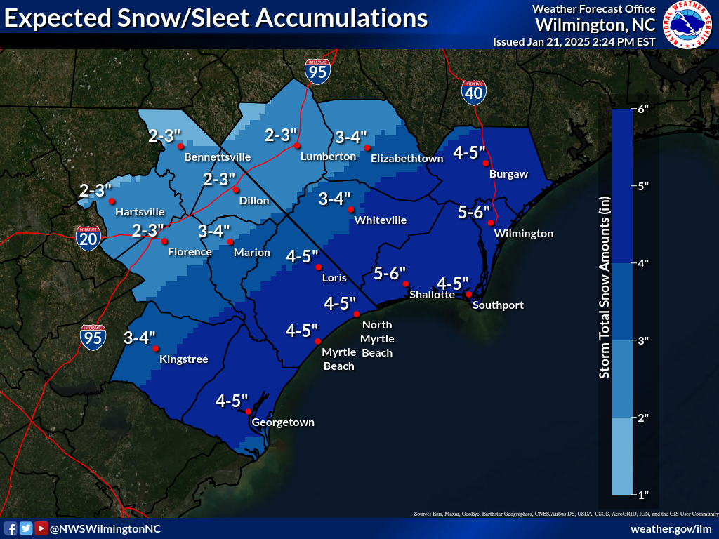
- The National Weather Service anticipates that there will be a combination of snow and sleet, especially along coastal areas from near Southport to Georgetown. Overall, the snow/sleet amounts have increased across the areas.
- Another consideration will be the potential for heavier bands of snow that may lead to isolated higher accumulations overnight.
- The snow will begin to come to an end west of I-95 from 2 to 5 AM Wed, and ending at the coast from 5 to 8 AM.
Tuesday, January 21, 2025, 1:45pm
City of Southport Offices Closed on Wednesday, January 22, 2025, due to Inclement Weather
City offices will be closed due to the threat of severe winter weather. Please follow Southport NC Emergency Information on Facebook for up to date information.
Administrative city staff will continue to work remotely. Public safety departments are staffed and prepared to respond to any emergencies.
Regular weather updates from the National Weather Service can be found on the city website here: https://buff.ly/4jilJjL.
Tuesday, January 21, 2025, 8:20am
*Confidence is HIGH for a moderate impact wintry precipitation event. Confidence is MODERATE regarding amounts and impacts.*
Highlights
- Snow probabilities have increased by this evening into early Wed morning
- Very cold weather will persist through the week
- Slight chance (20%) of another winter weather event Thu, with freezing rain or a wintry mix possible
- Updates
- A Winter Storm Warning is now in effect for Williamsburg, Georgetown, Horry, Columbus, Brunswick, New Hanover, and Pender Counties
- A Winter Weather Advisory is now in effect for Marlboro, Darlington, Florence, Marion, Dillon, Robeson, and Bladen Counties
- Probabilities for snow amounts have increased
Key Messages
- Very cold air will reside across the area today, and the abnormally cold temperatures will persist through the week. Make sure people and pets exposed to the cold are safe, and pipes/plants are protected.
- Probabilities for snow accumulations have increased, with the highest accumulation rates expected tonight, with precipitation coming to an end during early Wed morning.
- There is a slight chance (20%) that another storm system could bring wintry precipitation to the area Thu and Thu night, and it is too early to determine specific amounts/impacts if any.
Key Takeaways
- A long duration of abnormally cold weather will persist through much of this week with a threat to people/pets/pipes/plants that are exposed to the cold.
- Snow with some sleet accumulations are expected, especially tonight into early Wednesday morning when accumulation rates will be greatest. The snow/sleet will result in hazardous driving conditions tonight through Wed morning.
- There is a slight chance of another round of wintry precipitation, possibly a mix with freezing rain, Thu into Thu night.
Forecast Confidence
- High for tonight
- Low with the secondary weather system


Monday, January 20, 2025, 4:15pm
*Confidence is MODERATE to HIGH for a moderate impact wintry precipitation event. Confidence is MODERATE regarding amounts and impacts.*
Key Messages
- An arctic air mass will continue to build across the area resulting in a long duration event of abnormally cold temperatures. Prepare for the cold weather by making sure people and pets are safe, and pipes/plants are protected.
- Given the dominance of the arctic air mass the bulk of the moisture will remain off the coast limiting the amount of wintry precipitation across northeast SC and southeast NC.
- There is a slight chance that another storm system could bring wintry precipitation to the area Thu and Thu night, and it is too early to determine specific amounts/impacts if any.
Key Takeaways
- A long duration of abnormally cold weather persists through much of this week.
- Some snow is expected, especially late Tue afternoon through Tue night into Wed morning. Amounts are expected to be light but could still pose hazardous travel issues.
- Another round of wintry precipitation, possibly a freezing rain event, is possible Thu into Thu night.


Monday, January 20, 2025, 1:30pm
CANCELED: January 21, 2025 Basketball Games and Practices Due to the threat of severe winter weather and dangerous travel conditions, all basketball games, practices, and open gym hours have been canceled for Tuesday, January 21, 2025.
Monday, January 20, 2025, 9:00am
*Confidence is MODERATE to HIGH for a low impact wintry precipitation event Confidence is MODERATE regarding amounts and impacts*
Key Messages
- An arctic air-mass will continue to build across the area resulting in a long duration event of abnormally cold temperatures. Prepare for the cold weather by making sure people and pets are safe, and pipes/plants are protected.
- Given the dominance of the arctic air-mass the bulk of the moisture will remain off the coast limiting the amount of wintry precipitation across northeast SC and southeast NC.
- There is a slight chance that another storm system could bring wintry precipitation to the area Thu and Thu night, and it is too early to determine specific amounts/impacts if any.
Key Takeaways
- A long duration of abnormally cold weather will continue today and persist through much of the week.
- Some snow is expected, especially Tue afternoon through Tue night into Wed morning. Amounts are expected to be light but could still pose hazardous travel issues.
- Another round of wintry precipitation, possibly a freezing rain event, is possible Thu into Thu night.


Sunday, January 19, 2025, 5:00pm
*Confidence is INCREASING in wintry precipitation Confidence is LOW to MODERATE regarding amounts and impacts*
Key Messages
- Confidence remains high in very cold temperatures starting tonight and continuing into late week. Preparations for the unusually cold weather should be made by making sure people and pets are safe and pipes and plants are protected.
- Confidence continues to slowly increase regarding the chances/timing/impacts of wintry precipitation Tue into Wed, with the most impactful precipitation likely occurring Tue night.
- Another storm system could bring wintry precipitation to the area late Wed night through Thu night, although it is too early to determine specific amounts/impacts.
Key Takeaways
- A long duration of abnormally cold weather is expected beginning tonight and persisting through much of the week. The coldest temperatures are expected Wed night into Thu morning with some inland locations possibly dropping into the single digits.
- The likelihood for snow/sleet accumulations continues to slowly increase Tue into Wed, especially Tue night into early Wed. However, confidence is low to moderate regarding snow/ice amounts. Another round of wintry precipitation is possible late Wed night through Thu night.
- People are encouraged to closely follow this developing winter weather situation and make preparations for an extended period of cold weather and possible wintry precipitation by making sure people and pets are safe, and pipes and plants are protected.


Sunday, January 19, 2025, 10:00am
*Confidence is INCREASING that a winter weather event will occur Confidence is LOW regarding amounts and impacts*
Key Messages
- A very cold air mass will build across the area beginning tonight, resulting in an extended period of abnormally cold temperatures. Make preparations for the cold weather by making sure people and pets are safe, and pipes and plants are protected.
- Confidence continues to increase regarding the potential for some wintry precipitation generally from Tue afternoon into Wed morning. However, confidence with any accumulations of snow, sleet, and ice from freezing rain is low at this time.
- Another storm system Thu into Fri morning could bring another quick round of wintry precipitation to the area as well. It is too early for any specific information about this potential winter weather system.
Key Takeaways
- A long duration of abnormally cold weather is expected beginning tonight and persisting through much of the week. The coldest temperatures are expected Wed night into Thu morning with some inland locations possibly dropping into the single digits.
- The likelihood for snow/sleet accumulations continues to slowly increase, especially for Tue night into Wed morning. However, confidence remains low regarding snow/ice amounts. Another round of wintry precipitation is possible late Wed night through Fri morning.
- People are encouraged to closely follow this developing winter weather situation and make preparations for an extended period of cold weather by making sure people and pets are safe, and pipes and plants are protected.


Saturday, January 18, 2025, 8:00pm
* Increasing Confidence in Winter Precipitation Occurring Tuesday Afternoon into Wednesday Morning / Very Cold Temperatures Remain Likely Next Week*
Key Messages
- A very cold air mass will build across the area beginning Mon resulting in an extended period of abnormally cold temperatures. Make preparations for the cold weather by making sure people and pets are safe, and pipes and plants are protected.
- Confidence is increasing regarding the potential for wintry precipitation Tue afternoon into Wed morning. However, any accumulations of snow, sleet, and ice from freezing rain and locations is too early to tell and will be highly dependent on the track/evolution of the storm.
- Be alert for weather misinformation on social media. Oftentimes, people will show extreme scenarios with no context or a situation with little to no chance of occurring. Use credible sources of information including media partners, emergency managers, and the National Weather Service.
Key Takeaways:
- The likelihood for snow/sleet accumulations across southeast NC and northeast SC has increased, especially for Tue night into Wed morning. It is too early to determine the amount of accumulations and locations that will be impacted the most.
- A long duration of abnormally cold weather is expected beginning Mon and persisting through much of the upcoming week. The coldest temperatures are expected Wed night into Thu morning.
- People are encouraged to closely follow this developing winter weather situation and make preparations for an extended period of cold weather by making sure people and pets are safe, and pipes and plants are protected.
Forecast Confidence:
- High for cold temperatures
- Moderate for winter precipitation
Questions? Contact NWS Wilmington for 24/7 forecaster assistance.


Friday, January 17, 2025, 12:09pm
* Very Cold Temperatures Likely and Winter Precipitation Possible Next Week *
- Very cold temperatures are expected between Monday and Wednesday night with highs in the 30s and lows in the teens expected.
- Winter precipitation is possible between Tuesday afternoon and Wednesday morning.
- As is the case with winter storms near the coast, small differences in the exact track of the low pressure area can result in large differences in the precipitation type and possible impacts. Stay tuned for future updates.
Forecast Confidence:
- High for cold temperatures
- Low to Moderate for winter precipitation
Questions? Contact NWS Wilmington for 24/7 forecaster assistance.


Hurricane Helene, September 2024
Friday, September 27, 2024, 7:45am
- Latest Updates
- A Tornado Watch remains in effect. Tornado threat will continue today, mainly for this morning for northeast SC, and for later this morning into the early/mid afternoon for southeast NC. (see attached graphic from the Storm Prediction Center)
- Gusty winds will persist through today (graphic attached), and note that locally higher gusts are expected in/near thunderstorms
- Heavy rainfall is expected today, especially in the main band of storms that moves through this morning into the afternoon. The attached rainfall graphic is for additional what is expected for the remainder of the storm.
- The bulk of the rainfall will end for northeast SC by later this morning, and by early/mid afternoon for southeast NC


Thursday, September 26, 2024, 6:00pm
- What’s Changed
- Tornado threats higher
- Situation Overview
- Hurricane Helene is expected to make landfall near the Florida Big Bend this evening.
- Due to its large physical size, effects will be felt far away from the storm center, especially to its east.
- Local impacts will include tornados, gusty winds, isolated areas of flooding, and dangerous surf conditions.
- Watches and Warnings
- A Tropical Storm Warning remains in effect for all of northeast South Carolina
- A Tropical Storm Warning remains in effect for the coastal waters from South Santee River to Little River Inlet
- A Small Craft Advisory is in effect for the coastal waters from Little River Inlet to Surf City
- A High Surf Advisory is in effect for all beaches (does include South Carolina)
- Key Take-Aways
- Hurricane Helene will making landfall near the Big Bend of Florida. The storm will also become physically very large and its effects will extend a great distance from the center, especially to the east of the track.
- Tornadoes appear to be the main threat. Tornadoes at night can be particularly dangerous. Make sure to have a means of receiving overnight tornado warnings (NOAA weather radio, cell phone, etc.)
- Projected rainfall amounts of 1 to 2 inches (+isolated higher amounts) are possible, which could result in minor flooding issues. Areas hardest hit by last week’s heavy rain event will be particularly flood prone. Some area rivers could be impacted as a result.
- Wind gusts of 40-45 mph are possible across mainly coastal portions of northeast SC, elsewhere wind gusts of 30-35 mph expected. Gusts could be locally higher with any thunderstorms, especially with the band of thunderstorms late tonight into Friday especially in tornadic storms.
- Rough maritime conditions are expected across the coastal waters, along with steep waves around inlet entrances. Large breakers and strong rip currents are also expected in the surf.
- Minor coastal flooding is possible with each high tide along all coastal areas through Friday morning, and at downtown Wilmington and along the lower Cape Fear River through the weekend.
-


Thursday, September 26, 2024, 12:55pm
The Storm Prediction Center has expanded the enhanced (Level 3 of 5) across the area specifically for the tornado threat overnight into Friday morning.

Thursday, September 26, 2024, 7:00am
- What’s Changed
- No significant changes made.
- Situation Overview
- Hurricane Helene is expected to make landfall near the Florida Big Bend this evening.
- Due to its large physical size, effects will be felt far away from the storm center, especially to its east.
- Local impacts will include gusty winds, some areas of flooding, isolated tornadoes, and dangerous surf conditions.
- Watches and Warnings
- A Tropical Storm Warning remains in effect for all of northeast South Carolina
- A Tropical Storm Warning remains in effect for the coastal waters from South Santee River to Little River Inlet
- A Small Craft Advisory is in effect for the coastal waters from Little River Inlet to Surf City
- A High Surf Advisory is in effect for all beaches
- Key Take-Aways
- Hurricane Helene will make landfall near the Big Bend of Florida. The storm will also become physically very large and its effects will extend a great distance from the center, especially to the east of the track.
- Isolated tornadoes are possible, mainly tonight night into Friday, before the threat shifts away from this area.
- Projected rainfall amounts of 1 to 3 inches (+isolated higher amounts) are possible, which could result in some flash flooding. Areas hardest hit by last week’s heavy rain event will be particularly flood-prone. Some areas rivers could be impacted as a result.
- Wind gusts of 40 mph are possible across mainly coastal portions of northeast SC, elsewhere wind gusts of 30-35 mph are expected. Gusts could be locally higher with any thunderstorms. Winds are expected to increase tonight into Friday.
- Rough maritime conditions are expected across the coastal waters, along with steep waves around the inlet entrances. Large breakers and strong rip currents are also expected in the surf.
- Minor coastal flooding is possible with each high tide along all coastal areas through Friday morning, and at downtown Wilmington and the lower Cape Fear River through the weekend.


Wednesday, September 25, 2024, 6:00pm
- What’s Changed
- Tropical Storm Warning is now in effect for all of Northeast South Carolina and adjacent marine zones out to 20 nautical miles.
- Situation Overview
- Hurricane Helene is expected to make landfall near the Florida Big Bend on Thursday evening.
- Due to its large physical size, effects will be felt far away from the storm center, especially to its east.
- Local impacts will include gusty winds, some areas of flooding, isolated tornadoes, and dangerous surf conditions.
- Watches and Warnings
- Tropical Storm Warning is now in effect for all of Northeast South Carolina
- Tropical Storm Warning is now in effect from South Santee River to Little River Inlet out to 20 nautical miles
- Key Take-Aways
- Hurricane Helene will continue to rapidly strengthen in the Gulf of Mexico, making an eventual landfall near the Big Bend of Florida. The storm will also become physically very large and its effects will extend a great distance from the center, especially to the east of the track.
- Isolated tornadoes are possible Thursday night into Friday.
- Projected rainfall amounts of 1 to 2 inches (+isolated higher amounts) are possible, which could result in isolated flooding. Areas hardest hit by last week’s heavy rain event will be particularly flood-prone. Some areas rivers could be impacted as a result.
- Wind gusts of 40 mph are possible across mainly coastal portions of northeast SC, elsewhere wind gusts of 30-35 mph are expected. Gusts could be locally higher with any thunderstorms.
- Rough maritime conditions are expected across the coastal waters, along with steep waves around the inlet entrances. Large breakers and strong rip currents are also expected in the surf.
- Minor coastal flooding is possible with each high tide along all coastal areas, and at downtown Wilmington and the lower Cape Fear River.


Wednesday, September 25, 2024, 12:00pm
- Situation Overview
- Hurricane Helene is expected to make landfall near the Florida Big Bend Thursday evening
- Due its large physical size, effects will be felt far away from the storm center, especially to its east
- Local impacts will include gusty winds, some areas of flooding, isolated tornadoes, and dangerous surf conditions
- Watches & Warnings
- Tropical Storm Watch now in effect for Coastal Georgetown and Horry Counties
- Tropical Storm Watch now in effect from South Santee River to Little River Inlet out to 20 nautical miles
- Key Take-Aways
- Tropical Storm Helene is expected to rapidly strengthen into a hurricane today, making an eventual landfall near the Big Bend of Florida. The storm will also become physically very large and its effects will extend a great distance from the center, especially to the east of the track.
- Isolated tornadoes are possible Thursday night into Friday.
- Projected rainfall amounts of 1 to 2 (+isolated higher amounts) are possible, which could result in isolated flooding. Areas hardest hit by last week’s heavy rain event will be extra flood prone. Some area rivers could be impacted as a result.
- Wind gusts of 30 to 40 mph are possible across mainly coastal portions of northeast SC, elsewhere wind gusts of 25-30 mph expected. Gusts could be locally higher with any thunderstorms.
- Rough maritime conditions are expected across the coastal waters, along with steep waves around inlet entrances. Large breakers and strong rip currents are also expected in the surf.
- Minor coastal flooding is possible with each high tide along all coastal areas, and at downtown Wilmington and the lower Cape Fear River.


Potential Tropical Cyclone #8, September 2024
This is an ongoing recovery process as Southport and the surrounding areas rebuild.
CLICK HERE FOR THE MOST UP-TO-DATE TRAFFIC UPDATES
Thursday, September 26, 2024, 4:26pm
NC Department of Transportation Public Notice
UPDATE (Thursday afternoon) – While the left turn lane from N.C. 133 North to N.C. 87 is closed between 10 a.m. and 7 p.m., Jabbertown Road will also be closed to thru-traffic, but residents who live off Jabbertown Road will continue to have access.
When the left turn lane reopens at 7 p.m., Jabbertown Road will reopen, and will remain open until 10 a.m. This traffic pattern will be in place on weekdays, and the Brunswick County Sheriff’s Office will determine whether this pattern will continue over the weekend.
Below is a previous update and the original release.
UPDATE (Thursday morning) – The N.C. Department of Transportation in coordination with its partners at the Brunswick County Sheriff’s Office will remove the closure and allow the left turn from N.C. 133 North onto N.C. 87 each evening until further notice.
SOUTHPORT – Transportation officials are asking drivers to start taking an alternative route ahead of a detour that is set to be installed after rush hour Wednesday morning.
With N.C. 211 closed just north Southport, heavy traffic volumes have been using N.C. 87 North (River Road) toward Boiling Spring Lakes to leave the area. To adjust for this concentration of traffic, N.C. Department of Transportation crews have installed message boards along N.C. 211 to alert drivers who are trying to reach U.S. 17 or the Boiling Spring Lakes area to do so by way of N.C. 906 rather than N.C. 133 to N.C. 87.
As part of this traffic remedy, the left turn from N.C. 133 North onto N.C. 87 North is set to close after peak hours Wednesday morning. The detour will have drivers follow N.C. 211 North, N.C. 906 North, U.S. 17 Business North and U.S. 17 North back to N.C. 87.
Drivers should factor the alternative route into their trips and be mindful of crews working in the area.
Thursday, September 26, 2024, 12:30pm
SOUTHPORT – Transportation officials are asking drivers to start taking an alternative route ahead of a detour that is set to be installed after rush hour Wednesday morning.
With N.C. 211 closed just north Southport, heavy traffic volumes have been using N.C. 87 North (River Road) toward Boiling Spring Lakes to leave the area. To adjust for this concentration of traffic, N.C. Department of Transportation crews have installed message boards along N.C. 211 to alert drivers who are trying to reach U.S. 17 or the Boiling Spring Lakes area to do so by way of N.C. 906 rather than N.C. 133 to N.C. 87.
As part of this traffic remedy, the left turn from N.C. 133 North onto N.C. 87 North is set to close after peak hours Wednesday morning. The detour will have drivers follow N.C. 211 North, N.C. 906 North, U.S. 17 Business North and U.S. 17 North back to N.C. 87.
Drivers should factor the alternative route into their trips and be mindful of crews working in the area.


Wednesday, September 25, 2024, 11:37am

Friday, September 20, 2024, 4:28pm
Thursday, September 19, 2024
- Call Center for Questions & Assistance: 910-253-5383
- Baptist on Mission Cleanup Request Waiting List: ow.ly/SlqY50TqwTt
- Crisis Cleanup Hotline: 910-218-1569 (Open until Oct. 4, 2024)
- Brunswick Family Assistance (BFA) is offering the community free resources and supplies on Friday, Sept. 20 at Town Creek District Park (6420 Ocean Highway E, Winnabow) from 9:30 a.m. to 2 p.m. (while supplies last).
- Free Resources Include:
- Flood buckets (cleaning supplies, gloves, muck/gut tools)
- Health kits (toiletries, first aid, towels)
- Quilts
- Some brooms, mops, and shovels
- Backpacks filled with school supplies
- Kitchen kits for use in a hotel
Thursday, September 19, 2024, 2:18pm
The following is the latest information that we have on the status of reported concerns in Southport:
- Sewer System Inflow & Infiltration (A situation whereby stormwater and groundwater enter the wastewater system through breaks and cracks in pipes.)
- We have received reports of sewer manhole overflows. This is caused by the excessive amount of water (23” of rain) that flowed through the ground and stormwater system into the sewer system. The sewer system was turned over to the County, which is responsible for service response and maintaining the system. Please call: 910-253-2655, option 1 for Brunswick County Utilities office.
- Brunswick County Utilities crews are currently on the ground in Southport and addressing the stormwater concerns, including but not limited to Inflow and Infiltration overflow. Several projects in design will address these issues.
- Roadways
- Moore Street is still fully closed between Harbor Oaks and Turtlewood subdivisions.
- NC 211 is still fully closed between Rivermist subdivision and Walmart. This includes traveling from Dosher Cutoff. Dosher Cutoff is open to traffic only for those who live and/or work on that road.
- Since the collapsed roads are state-maintained, the City of Southport is working in conjunction with the NC Department of Transportation to assess and repair roadways in Southport. Currently, there is no timeline for the repair of E. Moore Street or NC 211 road collapses.
- Limit unnecessary travel as much as possible. Extensive travel on detour routes can still roadway failures, in addition to severe traffic congestion.
- City, county, and state officials are working together to determine viable evacuation routes, should the need arise while roadways and bridges are repaired.
- Damage Assessment and Clean-up
- As residents are completing damage assessments for potential insurance claims, the City of Southport is urging residents and business owners to document everything with pictures and videos, as well as taking measurements of water levels.
- Additionally, make a list of damaged or lost items and gather receipts. Doing this helps expedite the process with insurance and other assistance programs.
- City Staff has been in contact with our debris management contractor to establish a date for pick up. In the interim, place all home debris outside in the right-of-way and staff will send out notices when the debris pick-up date is set. Do not let debris overflow into the roadways.
- Brunswick County is planning to extend Free Cleanup Week from September 19-September 28, 2024, to accommodate the dates missed due to the storm. Please visit the Brunswick County landfill webpage for more details on what the landfill will accept: https://www.brunswickcountync.gov/422/Landfill.
- Assistance Options
- Governor Cooper has been in contact with City of Southport and Brunswick County officials since Tuesday, September 17, 2024 to discuss recovery and repair efforts needed in Southport. City officials and staff are working with the Governor’s office to identify additional assistance resources and when they may be available.
- Brunswick County Call Center for Questions & Assistance Needs: 910-253-5383
- Baptists on Mission Homeowners Assistance:
- Crisis Cleanup Hotline, until October 4th
- 910-218-1569
Wednesday, September 18, 2024, 4:45pm
- HWY 87 is the only way to get into and out of Southport at this time.
- E. Moore Street (near Turtlewood) and HWY 211 (between Rivermist and Walmart) will continue to be fully closed due to road collapse. DO NOT GO AROUND BARRICADES.
- As you clean up from the flooding, document everything with pictures and videos, including the water level lines.
- Brunswick County Landfill will reopen September 19, 2024 and Free Cleanup Week will be extended through September 28, 2024.
- Contact your home and flood insurance for next steps.
Tuesday, September 17, 2024, 3:00pm
- NO curfew tonight. However, continue to be vigilant of flooded roadways. If you encounter standing water, TURN AROUND, DON’T DROWN.
Tuesday, September 17, 2024, 9:48am
- GFL has suspended TRASH PICKUP on September 17, 2024.
Tuesday, September 17, 2024, 9:45am
- Moore Street between Ferry Rd and Leonard, washed out and fully closed
- 500 block of E. Moore Street at Bonnet Way, washed out and fully closed
- NC211 Bridge at Walmart, washed out and fully closed
- NC211 Bridge at Sacred Heart, washed out and fully closed
- W. 11th Street at Lord, ponding and fully closed
- Cape Harbor Drive, flooded homes
Monday, September 16, 2024, 6:06pm
-
A mandatory curfew has been established between the hours of 9:00 p.m. on September 16, 2024, and 7:00 a.m. on September 17, 2024. View the State of Emergency Declaration and curfew mandate here: https://cityofsouthport.com/city-of-southport-declares-state-of-emergency-and-mandatory-curfew-september-16-2024
Monday, September 16, 2024, 2:59pm
- What You Need to Know:
- There is an active Shelter in Place order. Do not leave your residences or places of employment.
- All inbound roads to Southport are closed to thru and non-essential traffic.
- If you have to leave your current location and you encounter standing water, DO NOT DRIVE THROUGH IT. Turn around, don’t drown.
- Protect yourselves, protect your first responders, stay home.
Monday, September 16, 2024, 2:49pm
-
EFFECTIVE IMMEDIATELY, ALL INBOUND LANES TO SOUTHPORT ARE CLOSED TO THRU AND NON-ESSENTIAL TRAFFIC.
Monday, September 16, 2024, 1:33pm
- Updated Road Closures
- W. 11th at Lord and Caswell
- Leonard St at Jabbertown Rd
- E. 11th at Brunswick Apartments
- Robert Ruark at Southport Way
- Fodale Ave at N. Howe, entrance to Dosher Memorial Hospital
- W. 12th from Howe to Caswell
- Cades Cove at 14th Street
- E. Moore St at Bonnets Creek
- HWY 211 at Duke Progress Canal (between Walmart and Dosher Cutoff)
Monday, September 16, 2024: 11:15am
- Southport Road Closures
- W. 11th at Lord and Caswell
- Leonard St at Jabbertown Rd
- E. 11th at Brunswick Apartments
- Robert Ruark at Southport Way
- Fodale Ave at N. Howe, entrance to Dosher Memorial Hospital
- W. 12th from Howe to Caswell
- Cades Cove at 14th Street
Monday, September 16, 2024, 10:12am
- CITY OFFICES CLOSING EARLY
- City offices will be closing early due to severe weather and flooding. Staff who are able will be working remotely.
- City Hall’s phones will not be monitored for the remainder of today, but the general email will be: coms@cityofsouthport.com.
Monday, September 16, 2024, 10:01am
- City of Southport Declares State of Emergency, September 16, 2024
- The State of Emergency can be viewed here: https://cityofsouthport.com/city-of-southport-declares-state-of-emergency-and-mandatory-curfew-september-16-2024/
Monday, September 16, 2024, 9:12am
- Our public safety crews and first responders have been receiving numerous reports of ponding and flooding of roadways in and around Southport.
- We encourage everyone to STAY HOME. Do not leave your residence, if possible. Flash flooding will continue as the rain continues.
 Remember, if you do leave your residence and encounter standing water in roadways, TURN AROUND, DON’T DROWN.
Sunday, September 15, 2024, 5:00pm
Tropical Storm Warning Issued
-
Tropical Storm WarningIssued: 2024-09-15 17:00:00 EDT|Expiring: 2024-09-16 01:00:00 EDTA Tropical Storm Warning means tropical storm-force winds areexpected somewhere within this area within the next 36 hours* LOCATIONS AFFECTED– Calabash– Holden Beach– Southport* WIND– LATEST LOCAL FORECAST: Equivalent Tropical Storm force wind– Peak Wind Forecast: 35-45 mph with gusts to 60 mph– Window for Tropical Storm force winds: until Monday evening– THREAT TO LIFE AND PROPERTY THAT INCLUDES TYPICAL FORECASTUNCERTAINTY IN TRACK, SIZE AND INTENSITY: Potential for wind 39to 57 mph– PLAN: Plan for hazardous wind of equivalent tropical stormforce.– PREPARE: Last minute efforts to protect property should nowbe complete. The area remains subject to limited winddamage.– ACT: Now is the time to shelter from hazardous wind.– POTENTIAL IMPACTS: Unfolding– Potential impacts from the main wind event are unfolding.* STORM SURGE– LATEST LOCAL FORECAST: Localized storm surge possible– Peak Storm Surge Inundation: The potential for 1-3 feetabove ground somewhere within surge prone areas– Window of concern: through early Tuesday morning– THREAT TO LIFE AND PROPERTY THAT INCLUDES TYPICAL FORECASTUNCERTAINTY IN TRACK, SIZE AND INTENSITY: Potential for stormsurge flooding greater than 1 foot above ground– PLAN: Shelter against storm surge flooding greater than 1foot above ground.– PREPARE: All flood preparations should be complete. Expectflooding of low-lying roads and property.– ACT: Stay away from storm surge prone areas. Continue tofollow the instructions of local officials.– POTENTIAL IMPACTS: Unfolding– Potential impacts from the main surge event are unfolding.* FLOODING RAIN– LATEST LOCAL FORECAST: Flood Watch is in effect– Peak Rainfall Amounts: Additional 4-8 inches, with locallyhigher amounts– THREAT TO LIFE AND PROPERTY THAT INCLUDES TYPICAL FORECASTUNCERTAINTY IN TRACK, SIZE AND INTENSITY: Potential formoderate flooding rain– PLAN: Emergency plans should include the potential formoderate flooding from heavy rain. Evacuations and rescuesare possible.– PREPARE: Consider protective actions if you are in an areavulnerable to flooding.– ACT: Heed any flood watches and warnings. Failure to takeaction may result in serious injury or loss of life.– POTENTIAL IMPACTS: Significant– Moderate flooding from rainfall may prompt some evacuationsand rescues.– Rivers and streams may rise and overspill their banks in afew places, especially in the typical prone locations.Small creeks and ditches may overflow.– Flood waters may enter some structures. Underpasses,low-lying spots along roadways, and poor drainage areas maybecome submerged by rising water. Some secondary streetsand parking lots may flood as storm drains and retentionponds overflow.– Driving conditions will become hazardous, and some roadclosures can be expected.* TORNADO– LATEST LOCAL FORECAST:– Situation is somewhat favorable for tornadoes– THREAT TO LIFE AND PROPERTY THAT INCLUDES TYPICAL FORECASTUNCERTAINTY IN TRACK, SIZE AND INTENSITY: Potential for a fewtornadoes– PLAN: Emergency plans should continue to include possibletornadoes.– PREPARE: Stay within your shelter keeping informed of thelatest tornado situation.– ACT: Move quickly to the safest place within your shelterif a tornado warning is issued.– POTENTIAL IMPACTS: Limited– The occurrence of isolated tornadoes can hinderpreparedness actions during tropical events.– A few places may experience tornado damage, along withpower and communications disruptions.– Tornadoes can cause damage to trees, vehicles, boats, andbuildings. Unsecured mobile homes and poorly constructedstructures are particularly vulnerable.* FOR MORE INFORMATION:– http://readyNCMonitoring conditions. The county has not taken any EM Actions at this time.We are monitoring conditions.- No official statement’s or issues thus far with regards to road conditions in the county. Some ponding and standing water reported, obviously.
Tropical Storm Debby, August 2024
NWS Wilmington Latest Briefing can be found here.
NOAA Debby Resources can be found here.
Friday, August 9, 2024, 10:49am, FINAL UPDATE
The Southport EOC team met this morning at 10 am and participated in the Brunswick County Conference Call. The following actions have been taken:
- The Southport State of Emergency will end at 11 am, August 9, 2024.
- Brunswick County will remain under a State of Emergency throughout the weekend due to River Flooding.
- City parks including Kingsley Dock, City Pier, City Dock, and the Riverwalk will return to open.
- A quick assessment of the City reveals no major damages or infrastructure deficiencies.
- The Southport EOC will be closed at 11 am today.
- Emergency Staffing was reduced at 8 pm yesterday evening.
This will be the final briefing for Tropical Storm Debby.
Respectfully,
Charles A. Drew
Fire Chief/Incident Commander
Thursday, August 8, 2024, 8:54pm
Thursday, August 8, 2024, 7:37pm
Thursday, August 8, 2024, 12:06pm
A quick update from the NWS Wilmington:
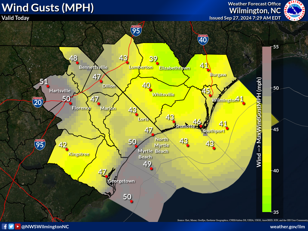
- Some adjustments were made to the additional expected rainfall (below). Main area of concern will be portions of Pender, New Hanover, and eastern Brunswick County.
- Peak wind gust graphic (below) adjusted as well with the highest gusts expected generally east of a Elizabethtown to Pawleys Island line
- The Tropical Storm Warning was cancelled for Marion, Florence, Williamsburg, and Georgetown Counties. It remains in effect for Horry, Columbus, Brunswick, coastal New Hanover, and coastal Pender Counties (see attached map below)
- The 1-3′ storm surge threat has subsided
- Please note: While Debby’s rainfall will exit the area later today and tonight an approaching front from the west could result in additional showers and a few thunderstorms during Friday, and into Saturday. These additional showers and thunderstorms could lead to localized flooding.


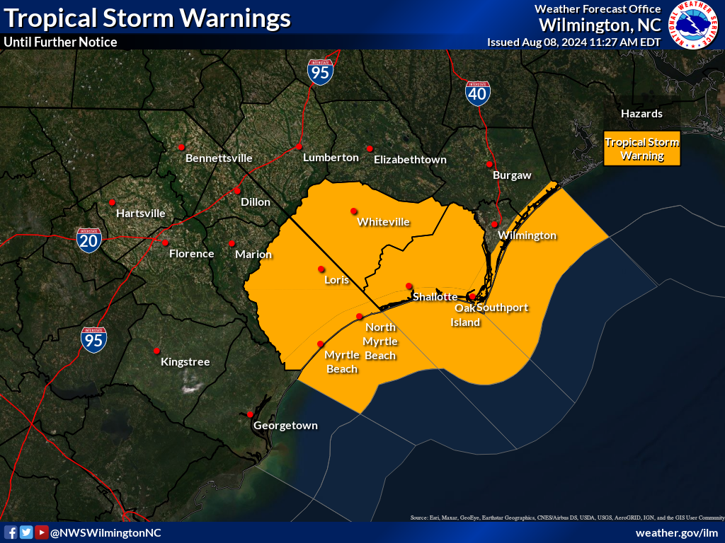
Thursday, August 8, 2024, 10:41am
- Tropical Storm Warning will continue for Brunswick County Coast throughout today.
- Southport has no unmet needs or resources.
- City streets are passable, with some ponding on the roads. No city streets are closed.
- 1100 block of East Moore Street was blocked last night by a down tree, but was cleared quickly.
- NCDOT website and Brunswick County Sheriff’s Office App, Web site, and Facebook Page has lists of all road closings
- Several more inches of rain and gusty winds are expected throughout today.
- City officers and parks remain closed until further notice.
- EOC staff will meet at 10am Friday to reevaluate the State of Emergency and City Offices.
Thursday, August 8, 2024, 7:53am
* Areas of Flash Flooding will continue *
Highlights
- Additional heavy rainfall today will further compound flooding in some areas
- Many roads have already been flooded, and water will continue to pool across low-lying areas even after the rainfall has stopped – Dangerous Driving Conditions Are Expected in many areas today
- The threat of tornadoes across southeast NC today will gradually shift away from the area
- Gusty winds to tropical storm force are also expected through today
Forecast Confidence: High
Key Points
- Debby will continue to move farther inland today, then begin to accelerate away from the region tonight into Saturday.
- Areas of flash flooding will continue as water pools into low-lying areas, and additional heavy rainfall occurs today. This is a dangerous situation, do not drive through flooded areas, and seek higher ground if flooding threatens your area.
- Tropical storm force winds are also possible, especially across eastern areas of northeast South Carolina and southeast North Carolina, and the adjacent Atlantic waters.
- Storm surge inundation of 1 to 3 feet could result in some mostly minor coastal flooding along the beach front and tidal areas, especially during high tide later this morning. Coastal Flooding along the lower Cape Fear River (including downtown Wilmington) will continue with the next several high tides.
- The threat for isolated tornadoes will continue for southeast North Carolina, especially this morning. The tornado threat will gradually shift away from the area during the day.


Summary
- Areas of flash flooding will continue today as water pools into low-lying areas and supported by additional heavy rainfall. Do not attempt to drive across flooded areas as your vehicle may become swept off the roadway.
- Tropical Storm force gusts will continue today, especially east of a Lumberton, NC to Andrews, SC line and the adjacent Atlantic waters.
- Isolated tornadoes are possible for southeast NC, especially this morning, with the threat shifting away from the area during the afternoon.
- Minor coastal flooding is possible, especially with high tide late this morning. Coastal flooding along the lower Cape Fear River (including downtown Wilmington) will continue with the next several high tides.
Wednesday, August 7, 2024, 5:31pm
* Considerable Flooding Expected *
Highlights
- Additional heavy rainfall is expected to create considerable flooding across portions of the area tonight into Thursday. Driving will become hazardous, especially at night when it is harder to recognize flood dangers.
- Tropical storm force winds are possible tonight into Thursday for some of the area as Debby moves inland from the central SC coast tonight then northward during Thursday.
- The threat of tornadoes will continue through tonight into Thursday morning.
- Some coastal flooding is possible with each high tide tonight, and late Saturday morning.
Forecast Confidence: High with heavy rainfall/flooding and tornadoes, moderate with surge and winds.
Key Points
- Tropical Storm Debby will slowly move back toward the South Carolina coast tonight making landfall. Debby will begin to pick up forward speed late Thursday and Friday.
- Considerable flooding is expected. Additional heavy rainfall is expected, especially tonight through Thursday. Be especially cautious at night when flooding dangers are harder to recognize.
- Tropical storm force winds are also possible, especially along the coastal areas and portions of Horry and Georgetown counties and the adjacent Atlantic waters.
- Storm surge inundation of 1 to 3 feet could result in some mostly minor coastal flooding along the beach front and tidal areas, especially during high tide tonight and high tide late Thursday morning.
- The threat for isolated tornadoes will exist tonight into Thursday morning. The tornado threat will gradually shift into eastern North Carolina and southeastern Virginia during Thursday.


Summary
Confidence is high regarding the progression of Debby, the potential for considerable flooding, and isolated tornadoes. Confidence is moderate regarding wind and surge impacts.
- Considerable flooding is expected tonight through Thursday. Do not attempt to drive across flooded areas as your vehicle may become swept off the roadway.
- Tropical Storm force winds are possible, especially across coastal areas, Georgetown and Horry Counties, and the adjacent Atlantic waters.
- Isolated tornadoes are possible through tonight, with the threat shifting away from the area during Thursday.
- Storm surge inundation of 1 to 3 ft is possible, especially with high tide tonight and late Thursday morning.
Wednesday, August 7, 2024, 11:49am
The Southport EOC Command staff met this morning at 10am. We participated in the Brunswick County Conference Call with all other municipal partners. The following information was discussed:
- Updated briefing from the National Weather Service. The immediate Southport area will have less impact than predicted yesterday. Less rainfall totals, wind impacts, and storm surges. This could change depending on the storm’s strengthening or track of the storm.
- The consensus of the meeting was to stay the course and re-evaluate the State of Emergency Declaration in the morning.
- Essential city staff is positioned and ready to respond to all needs.
- The EOC is at a partial activation, with phone lines being manned, and the PIO is on-site to disseminate any information to our citizens as needed.
- WEB EOC event has been established by Chief Drew & Chief Coring, for any needs or resources from the State or County.
- Contacts and communications are ongoing with Dosher Hospital and all other nursing facilities in the city.
Respectfully,
Charles A. Drew
Fire Chief/Incident Commander.
Wednesday, August 7, 2024, 7:50am
* Considerable Flooding Possible *
Highlights
- Some areas received 2 to 5 inches of rainfall yesterday, and an additional 4 to 9 inches is possible today through Thursday – this amount of rainfall will result in flash flooding in some areas
- Isolated tornadoes are possible today into Thursday morning, then the threat of tornadoes will shift into eastern NC during the day
- 2 to 4 ft storm surge inundation is still possible, especially for Brunswick, Horry, and Georgetown Counties with high tide tonight and Thursday morning
Forecast Confidence: High concerning rainfall/flooding and tornadoes, moderate with wind and surge
Key Points
- Tropical Storm Debby will slowly move just off the South Carolina coast today, then make landfall along the South Carolina tonight. Debby will begin to pick up forward speed late Thursday and Friday.
- The very slow progression of the storm will result in heavy rainfall and the potential for considerable flooding. In some areas 2 to 5 inches of rain had fallen yesterday, and an additional 4 to 9 inches is possible today into Thursday.
- Tropical storm force winds are also possible, especially along coastal areas and the adjacent Atlantic waters.
- Storm surge inundation of 2 to 4 feet south of Cape Fear, and 1 to 3 ft north of Cape Fear is possible, especially during high tide tonight and Thursday morning.
- The threat for isolated tornadoes will exist today and tonight, then the threat will gradually shift into eastern North Carolina and southeastern Virginia during Thursday.


Summary
Confidence is high regarding the progression of Debby, the potential for considerable flooding, and isolated tornadoes. Confidence is moderate regarding the exact extent of wind and surge impacts.
- Considerable flooding is still possible today into Thursday. Do not attempt to drive across flooded areas as your vehicle may become swept off the roadway.
- Tropical Storm force winds are possible, especially along coastal areas and the adjacent Atlantic waters.
- Isolated tornadoes are possible today and tonight, with the threat shifting away from the area during Thursday.
- Storm surge inundation of 2 to 4 ft is possible from Cape Fear southward, and 1 to 3 ft is possible north of Cape Fear, especially with high tide tonight and Thursday morning.
Tuesday, August 6, 2024, 5:47pm
* Life-threatening Flash Flood Expected *
Highlights
- An additional 10 to 15 inches of rainfall is possible through Thursday night
- Tropical storm force winds are possible, especially along the northeast SC coast Wednesday into Thursday
- The threat of tornadoes will persist tonight through Thursday night


Tuesday, August 6, 2024, 12:50pm
The department heads met this morning at 10 am in the EOC. The following protective actions have been established:
- The City of Southport will enter an official State of Emergency beginning at 12 noon today.
- A voluntary evacuation of all low-lying areas and flood-prone areas is recommended.
- All non-essential city personnel will be released at 12 noon today.
- All City Meetings are canceled through Saturday.
- All City Parks including Kingsley Dock, City Pier, City Dock, and Riverwalk are closed as of 12 noon today.
- The Southport EOC will open at 8am on Wednesday, the number to call will be 910-457-7915 for requests, questions, or concerns.
- Fire Headquarters will be without electricity from 12 noon to 4pm today, so we can manually switch to emergency power through the duration of the storm.
- Hotel Rooms have been secured for essential personnel, (police and public works). This is to ensure that our employees can access the city due to flooding.
- Food supplies are being purchased to feed our essential employees that are working.
- The Police Department’s High Clearance Vehicle is being staged at the new PD in case it is needed for evacuation or transports.
- Water Rescue Boats/Apparatus is being staged through out the fire district/city in case it is needed for emergency calls.
- Parks & Recreation bus and vans are ready to be deployed if needed for evacuation purposes.
- All essential personnel have been placed on standby and are ready to work through the duration of the storm.
It is forecasted that Debby will be mainly a rain event with 10-15 inches of rainfall predicted over the course of the storm. Winds will be minimal, and they are predicting a 2–4-foot storm surge on Thursday evening. The threat of tornado activity has increased, with one tornado warning being issued for Brunswick County at 0830 hours today.
Respectfully,
Charles A. Drew
Fire Chief/Incident Commander
Tuesday, August 6, 2024, 12:06pm
CITY OF SOUTHPORT HAS DECLARED A STATE OF EMERGENCY AHEAD OF TROPICAL STORM DEBBY
The City of Southport has declared a State of Emergency, effective at noon on August 6, 2024. The following cancellations and closures have been announced:
- CLOSURES
- City Offices will close at noon on August 6, 2024, and be closed until further notice
- City Parks, City Dock, and City Pier will close at noon on August 6, 2024, and be closed until further notice
- CANCELLATIONS
- Tuesday, August 6, 2024: Board of Aldermen/Center for the Creative Arts Southport Joint Workshop
- Wednesday, August 7, 2024: Historic Preservation Commission Regular Meeting
- Thursday, August 8, 2024: Board of Aldermen Regular Meeting
The City of Southport Emergency Operations Center (EOC) will be activated at 8 am on Wednesday, August 7, 2024. The main line for the EOC is (910) 457-7915.
Emergency Information and resources can be found here: https://cityofsouthport.com/emergency-information/#named-storm-information
View/Download State of Emergency Declaration
Tuesday, August 6, 2024, 11:54m
- coastal Pender, New Hanover, and Brunswick Counties
- central Horry County
- Inland Georgetown County
- Williamsburg County
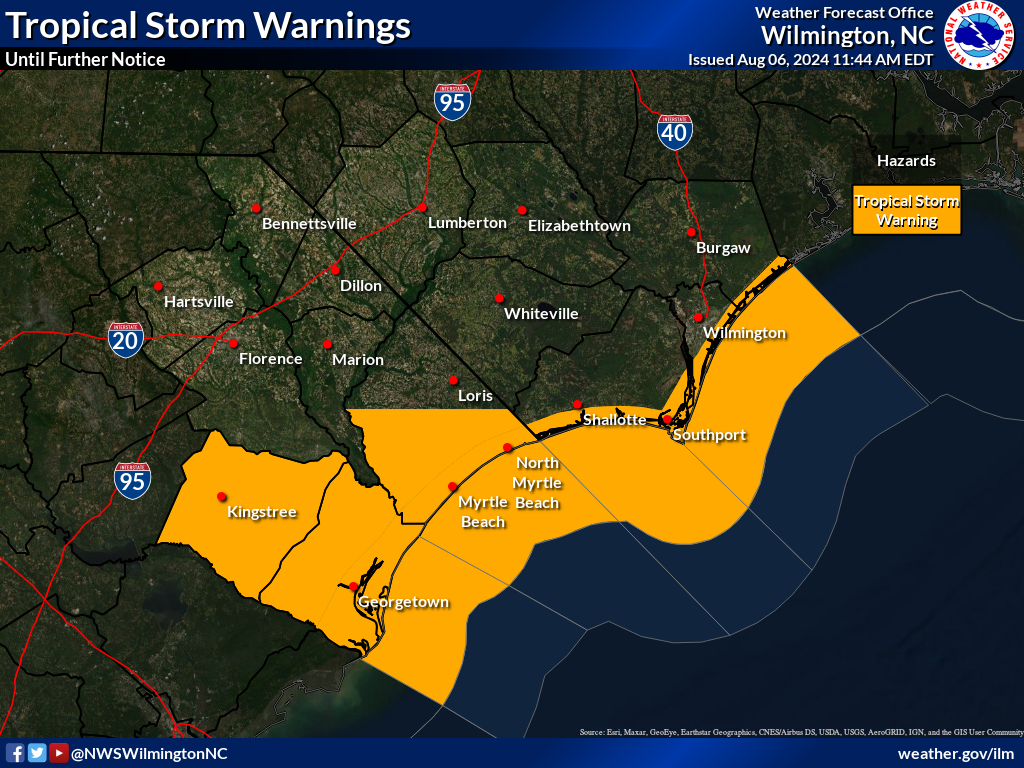
Tuesday, August 6, 2024, 7:53am
* A Life-threatening Flood Event will begin, and persist into Friday *
Highlights
- Extreme rainfall with projected 10 to 15 inch amounts, and some areas with 15 to 20 inches, will result in life-threatening flooding. The flooding risk will increase today into Wednesday and Thursday, then begin to decrease during Friday
- Storm surge inundation of 2 to 4 feet is possible for Brunswick, Horry, and Georgetown Counties where a Storm Surge Watch is currently in place
- Isolated tornadoes are possible today through Thursday
Forecast Confidence: High with respect to heavy rainfall and flooding, medium with surge, wind, and tornadoes.
Key Points:
- Tropical Storm Debby will move off the coast today, then slowly move off the South Carolina coast through Thursday morning. Debby will likely make landfall during Thursday, then begin moving northward Friday into Saturday.
- The very slow progression of the storm could result in catastrophic amounts of rainfall across northeast South Carolina and southeast North Carolina, which would result in life-threatening flash flooding.
- Tropical storm force winds are possible, especially for coastal portions of Long Bay (Brunswick, Horry, and Georgetown Counties), and storm surge inundation of 2 to 4 feet is also possible in these areas.


Monday, August 5, 2024, 5:58pm
This graphic below depicts average rainfall amounts, and as a result isolated higher amounts are possible.

Monday, August 5, 2024, 5:52pm
Highlights
- Very heavy rainfall is expected to occur across portions of southeast NC and northeast SC over the next few days resulting in life threatening flash flooding
- Some storm surge is also possible, a Storm Surge Watch is now in effect for Brunswick, Horry, and Georgetown Counties
- A Tropical Storm Watch is also in effect for Brunswick, Horry, and Georgetown Counties
- Reminder, the river forecasts contain 48 hours of forecast rainfall, and do not reflect the entire amount of rainfall expected from Debby given it is such a long duration event.
Forecast Confidence: High with respect to heavy rainfall/flooding, moderate with wind, surge, and tornadoes.
Monday, August 5, 2024, 3:02pm
The City of Southport Department heads met regarding the potential Tropical Weather that is pending. This is a synopsis of the meeting:
Chief Drew briefed everyone on the Conference Call that was held with Brunswick County, the following was shared:
- Weather Briefing: Hurricane Debby made landfall earlier this morning in Florida. The storm will weaken through the afternoon, and eventually cross the state of Florida, entering the warm Atlantic Waters. The storm is predicted to sit over the open waters for 2 days and provide the Carolinas with extreme amounts of moisture. The storm is predicted to move or begin to drift Northward Wednesday evening into Thursday Morning. During this time the immediate area will have torrential rain, wind gusts up to tropical storm force, and a risk of tornadoes. There is likely a 1–2-foot storm surge for the Southport area and 12-16 inches of rain. Flashflood warnings are expected. By 5pm this evening we could start seeing tropical and storm surge advisories. If the storm tracks more to the east, it could mean greater impacts for our area.
- City staff has prepared their respective departments, buildings, and areas in anticipation of Hurricane Debby.
- Residents are urged to follow all guidelines from city and county officials as the storm approaches.
There will be an additional conference call in the morning with EOC staff and separtment heads. At that time, decisions will be made in regard to street closures, city offices, any needed declarations, and meeting cancelations.
Respectfully,
Charles A. Drew
Incident Commander
Fire Chief
Monday, August 5, 2024, 9:10am
Highlights
- Heavy rainfall will likely result in life-threatening flash flooding across portions of northeast SC and southeast NC this week given how slow Debby will be moving
- Tornado risk will increase some by tonight, with a risk continuing through mid-week
- Other impacts are expected to include wind gusts to tropical storm force and some surge – it’s too early for specific details at this time given some forecast uncertainty beyond Wednesday.
Forecast Confidence: High concerning heavy rainfall/flash flooding, moderate with other hazards.
- Debby is expected to cross northern Florida today and move near the Georgia/South Carolina coast during Tuesday. The storm will move very slowly near the South Carolina coast Wednesday and Thursday before moving northward.
- The very slow progression of the storm could result in catastrophic amounts of rainfall across northeastern South Carolina and southeastern North Carolina, which would result in life-threatening flash flooding. Otherwise, gusty winds, some surge, and a few tornadoes are also possible – but it is too early to predict these specific impacts with detail given the uncertainty in the track beyond Wednesday.
- All interests in the Carolinas, and marine interests across the coastal waters, should continue to prepare for this evolving weather situation.


Sunday, August 4, 2024, 8:43am
Highlights – the potential for LIFE-THREATENING flooding is increasing
- Debby is forecast to slow down considerably near the Georgia/South Carolina coast during this week. The very slow progression will result in significant rainfall and the potential for areas of flash flooding.
- Much uncertainty exists with the longer-range track of the storm given the storm will become situated in a prolonged area of weak steering.
Forecast Confidence: High regarding flooding impacts, moderate with remaining impacts.
Saturday, August 3, 2024, 10:41am
Highlights
- Expected arrival time of tropical storm force winds is later than in previous forecasts
- Rainfall amounts have increased
- Heavy showers and storms are possible over the next few days as a weak front stalls and tropical moisture is brought northward
- Elevated wave heights will remain a hazard for small craft well-ahead of the system
Forecast Confidence: Medium
Friday, August 2, 2024, 3:56pm
- The primary concern at this time is with respect to heavy rain and flash flooding. Prior to the arrival of any PTC4 rainfall we expect rounds of heavy rainfall associated with a front expected to be across the area this weekend.
- The threat of strong rip currents, rough surf, and hazardous maritime conditions will also be increasing during the weekend, but especially the first part of next week.
- Gusty winds are also possible, but it’s too early to tell how impactful winds will be.
- All residents are advised to closely follow this developing weather situation.
Friday, August 2, 2024, 1:17pm
Potential Tropical Storm that could affect Brunswick County early next week
- As of 11 a.m., the National Hurricane Center is issuing advisories on Potential Tropical Cyclone Four, which will be named Debby if it reaches Tropical Storm Strength. Regardless of its intensity or categorization, the system could bring wind and rain to Brunswick County early next week.
- While it is still too early to predict exactly what impacts, if any, we will see from this system, now is the time to prepare. Residents are encouraged to monitor the system and to obtain information from accurate, credible sources. Please feel free to visit the National Hurricane Center’s website for the most up to date information.
Tropical Storm Ophelia, September 2023
Friday, September 22, 2023, 6:30pm
Tropical Storm Ophelia will continue to move toward the NC coast tonight bringing a variety of impacts to the area.
- Conditions are expected to gradually improve during Saturday as Ophelia moves away from the area towards the north.
- A quick summary of impacts that are expected across northeast SC & southeast NC include:
- Heavy rainfall with amounts of 2 to 4 inches across portions of southeast NC with 4 to 8 inch amounts across Pender, New Hanover, and eastern Brunswick Counties
- Some storm surge/coastal flooding (1-3’ inundation above ground level, especially north of Cape Fear)
- Strong winds of 20 to 30 mph, with gusts to 40 to 50 mph especially along the coastal areas around Cape Fear northward to Surf City, NC (higher gusts are expected just off the coast).
- Strong rip currents and very rough surf
- Hazardous maritime conditions with large/steep seas
Friday, September 22, 2023, 5:00pm
Tropical Storm Ophelia has formed.
Tropical Storm Ophelia will continue to move toward the NC coast tonight bringing a variety of impacts to the area.
- Conditions are expected to gradually improve during Saturday as Ophelia moves away from the area towards the north.
- A quick summary of impacts that are expected across northeast SC & southeast NC include:
- Heavy rainfall with amounts of 3 to 6 inches across portions of southeast NC with 6 to 8 inch amounts across Pender, New Hanover, and eastern Brunswick Counties
- Some storm surge/coastal flooding (1-3’ inundation above ground level, especially north of Cape Fear)
- Strong winds of 20 to 30 mph, with gusts to 40 to 50 mph especially along the coastal areas around Cape Fear northward to Surf City, NC (higher gusts are expected just off the coast).
- Strong rip currents and very rough surf
- Hazardous maritime conditions with large/steep seas
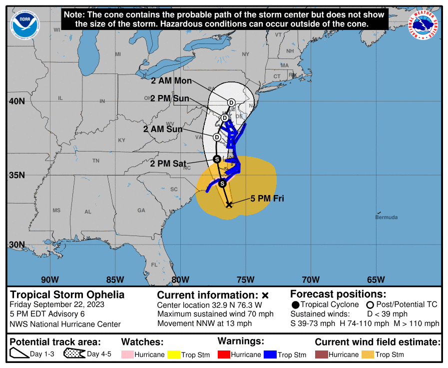
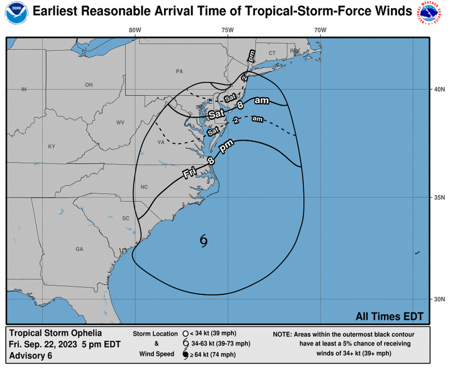
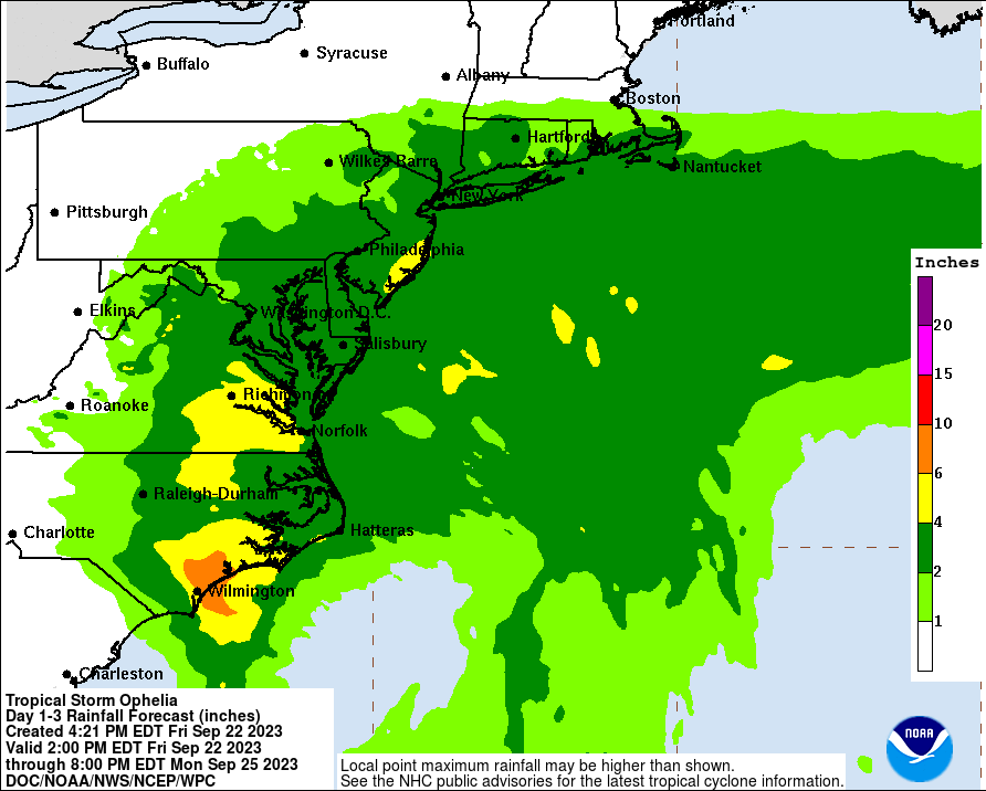
Hurricane Idalia, August 2023
Wednesday, August 31, 12:00pm
After reports from the Emergency Operations Team, there is little to no damage from the effects of Idalia. The following reports have come in:
Incident Commander:
- Very few calls into the EOC during the storm.
- The EMS crew had 12 medical emergency calls since the opening of the EOC.
- The Fire crew had 5 emergency calls during the opening of the EOC.
- 1 residential structure fire.
- 1 vehicle with 2 occupants trapped in floodwater
- The EOC was partially open, and manned by me, Chief Coring, and City Manager Therrien.
- Communication was established with Tom Stanley, for Public Work Needs.
- Went through 4 tornado warnings, during the storm.
- Kept a constant check on electric outages during the storm on the BEMC website.
Police:
- Officers checked the city overnight and this morning.
- No issues to report.
- The road due to flooding East Leonard Street between Jabbertown & Firefly @ 0130, has since been reopened.
- The stoplight at Moore & Howe has been flashing, this was reported to DOT.
Communications/Tourism:
- The director completed an interior review of Ft Johnston, the Community Building, and the Indian Trail Meeting Hall.
Public Works:
- Erosion on 200 block of Bay Street – Minimal.
- Sidewalk on 200 Block of Bay Street – Repairs will be needed, but very minimal.
- Minimal debris on roads.
Parks & Recreation:
- Minimal Damages to all parks – Leaf & Debris.
- All Buildings appear fine.
I & Chief Coring participated in the Brunswick County Conference Call at 10 a.m. this morning. No needs or resources were requested. I made a report to the county on our damage assessment. The Southport EOC will close at 12 noon today, and we will resume normal operations. I would like to meet with all department heads for a debriefing on the entirety of the storm at 0830 hours, Friday, September 01, 2023, in the EOC. During this time, we can discuss our strengths and weaknesses, and any improvements we need for future storm-related incidents.
I would like to personally thank City Manager Therrien, She is the first city manager that I have worked with since being fire chief and has stayed the entire time with us in the EOC! Also, Chief Coring and Director Tom Stanley and their employees have done a great job during this storm. Public Works and the Police Department were here and responsive during the whole storm! Lastly, the fire and EMS crews were such an asset to the whole operation. They have answered calls, cooked, and fed personnel, and kept the station neat and clean. The City of Southport has a great team of employees! Thank you to everyone who helped, assisted, worked, or supported staff during this event.
Respectfully,
Chief Charles A. Drew
Fire Chief/Incident Commander
City of Southport
Tuesday, August 30, 8:30pm
Tropical Storm Idalia will move up the Carolina coast tonight into Thursday. The main impact will be heavy rain and localized flooding. Isolated tornadoes are also expected, mainly along the coast. A Tornado watch has been issued for Southport and nearby local areas until 4:00 a.m.
Tropical storm-force winds may cause downed trees and power outages. The highest chance of wind-related impacts will be along the coast. Minor storm surge is also possible primarily around high tides this evening and Thursday. Gusty winds will continue as Idalia exits the area. Downed trees and power lines are possible due to the winds and saturated soils on Thursday.
Tuesday, August 30, 2:10pm
The City of Southport Emergency Operations Team met this morning at 0930 in the EOC. The following is a summary of the meeting:
- Incident Commander:
- Weather Update and Briefing held.
- Fire/EMS crews are all on standby.
- Supplies/Food for storm preparations are complete.
- Essential employee list was completed by City Manager yesterday.
- All our partners have been contacted and established lines of communication with, BEMC, Dosher Hospital, Southport Rehab, Terra Bella, Brunswick County Emergency Management, & NC Emergency Management.
- WEB EOC is up and running.
- City Manager:
- Closing City Hall at 12 noon today, re-open 12 noon tomorrow.
- Make sure all vehicles are fueled.
- With the partial EOC opening, will only need Fire, Police, City Manager, and Public Works Director.
- Any trash collection for Thursday, will be picked up on Saturday.
- Police:
- High Clearance Vehicle is ready and in place.
- Staff is on standby.
- Parks & Recreation:
- Bus/Van gassed up and ready if needed for transports or evacuation helps.
- They will have children at P&R Building until 2pm today.
- Programs/Activities closed Thursday.
- Requested for Public Works to secure swings and trash cans.
- Mayor Hatem:
- His main concern is the Public Health and Safety of the employees, citizens, and visitors.
- Keep communications open with briefings and press releases.
- Southport is in good hands, with experienced employees.
- Public Works Director:
- Staff is ready and on standby.
- EOC will contact Tom if things are needed.
- City Engineers are on standby to assist Tom if needed.
- Assistant City Manager/Clerk to the Board:
- FEMA forms will be emailed to all department heads at the close of this meeting.
- FEMA has 5 different forms, Dorrie has condensed them into 2 main forms we will use to track expenses, calls, and employee hours.
- State of Emergency has been prepared and will be emailed to Mayor, Incident Commander, and City Manager before leaving today, if needed.
- Planning/Building Inspections:
- Staff is ready if needed to do Post-Storm assessment.
- Community Relations/Tourism:
- Visitor’s Center is closed today and tomorrow.
- Community Building is closed.
- Animal Protective Services:
- Operational.
- Public Information Officer:
- Leaving for out-of-town trip at 7:30pm this evening.
- Will have laptop and city cell phone if needed.
- Assistant PIO is prepared as the back up and has been trained.
- Leaving for out-of-town trip at 7:30pm this evening.
Immediately following the City’s meeting, the team participated in a Brunswick County Conference Call with all municipalities and county partners.
The City of Southport remains very vigilant and aware of this storm. I am watching every briefing and update with precision, and if there are any significant changes, I will update you as soon as possible. Non-essential employees have been released, and essential staff is ready and on standby. If citizens have any needs, please have them call 910-457-7915.
Respectfully,
Chief Charles A. Drew
Incident Commander
City of Southport
Tuesday, August 30, 12:55pm
What has changed:
- Tropical Storm Watches upgraded to Tropical Storm Warnings
- Tornado Risk has increased
- New river flood updates
- Wind gusts increased across the adjacent coastal waters
Tuesday, August 30, 10:25am
- The tornado risk for portions of northeast SC and southeast NC has been increased to an Enhanced Risk (3 of 5).
- The risk will increase as bands of storms move onshore, especially this afternoon and evening.
- A Tornado Watch may be needed to highlight this threat
- Be prepared to seek shelter if Tornado Warnings are issued for your area
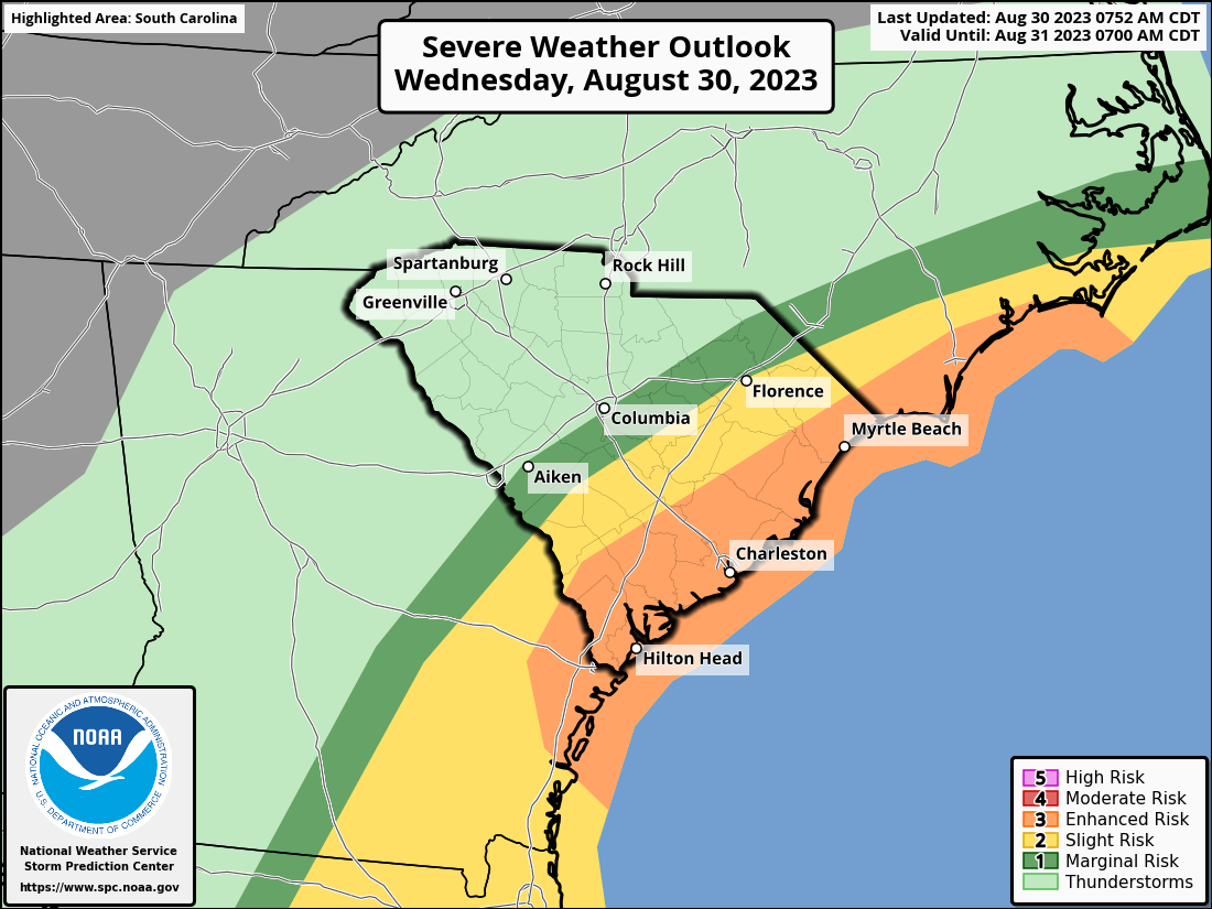
Tuesday, August 30, 9:30am
What has changed:
- Tropical Storm Watches and Warnings expanded
- High Surf Advisory and Coastal Flood Warning now in effect
- Rainfall totals have been increased
- Increased river flood threat
- Expected wind speeds have been increased
Idalia will make landfall along the west coast of FL this morning. The storm will move
across southeast Georgia later today to the SC coast late tonight.
- It is possible that Idalia could be a strong tropical storm or hurricane early Thursday morning as it moves near the SC coast.
- Impacts will begin to increase across northeast SC and southeast NC later today, through tonight, and Thursday. These impacts include:
- Heavy rainfall and dangerous flash flooding
- A few tornadoes and waterspouts
- Some storm surge/coastal flooding
- Gusty winds exceeding 40 mph (tropical storm force)
- Strong rip currents from Hurricane Franklin off to the east and from Idalia
- Hazardous maritime conditions
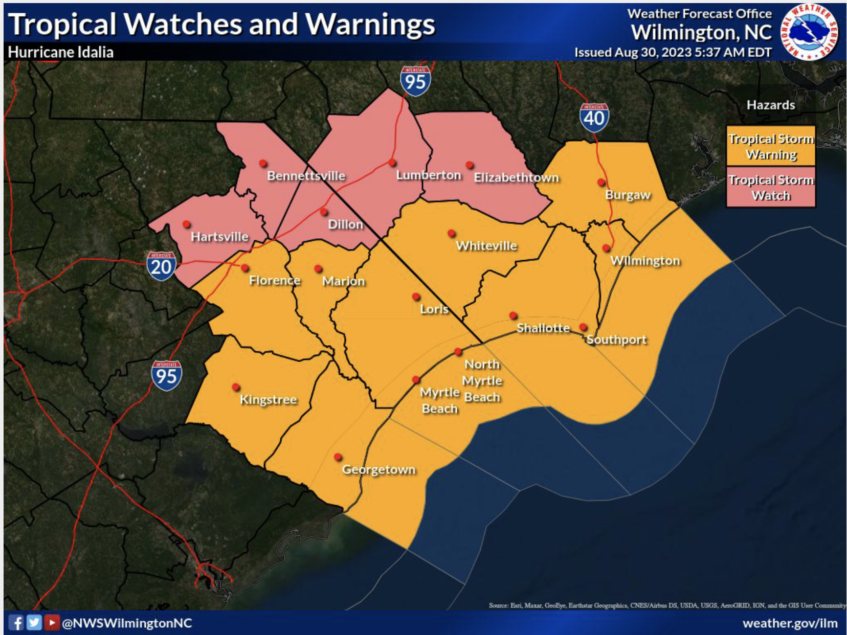

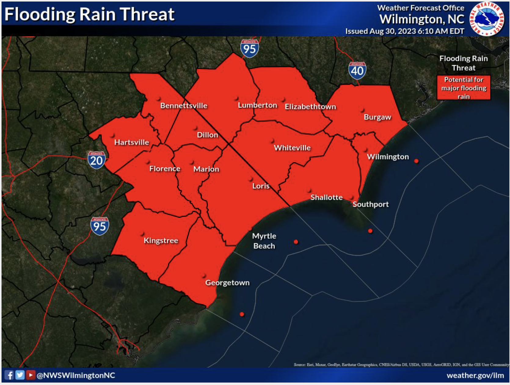
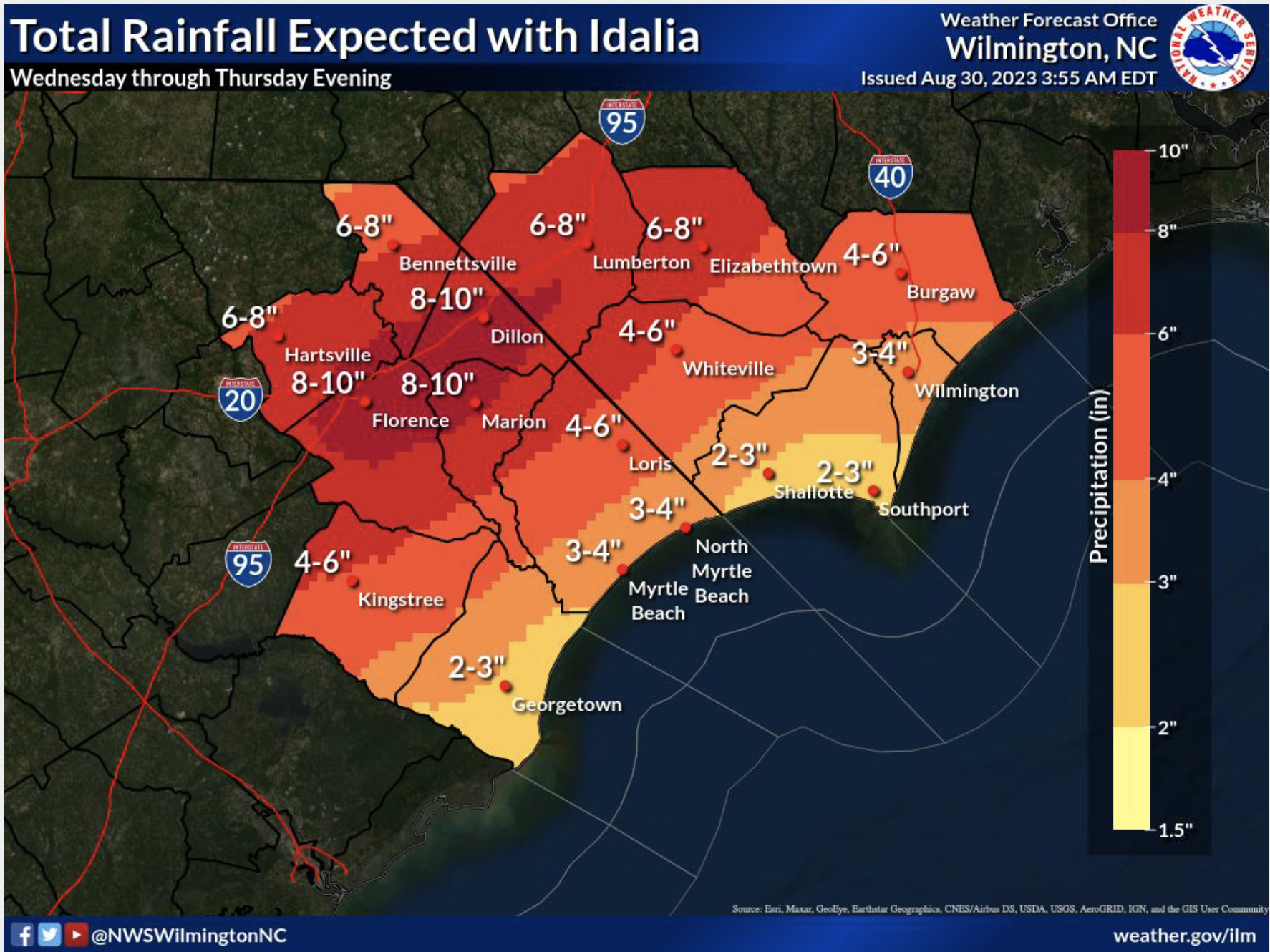
Tuesday, August 29, 2023, 7:45pm
What has changed:
- Tropical Storm Warning now in effect for Williamsburg, Georgetown, Horry, Coastal Brunswick, Coastal New Hanover, & Coastal Pender Counties
- Tropical Storm Warning for coastal waters from Surf City to South Santee River out 20 nautical miles.
- Flash Flood Watch for Southeast North Carolina and Northeast South Carolina Wednesday Afternoon through Thursday
- Added Mostly Likely Time of Arrival for Tropical Storm Winds.
The latest briefing can be found here.
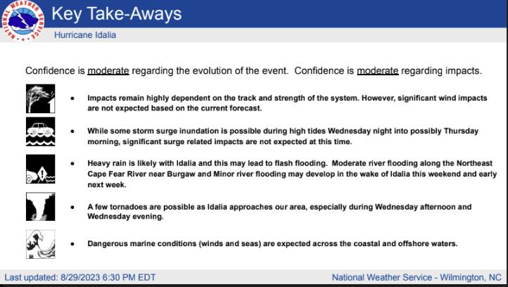
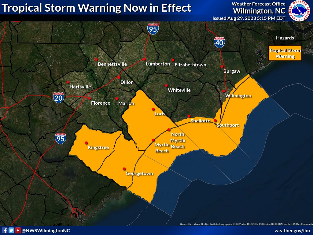
Tuesday, August 29, 2023 4:30pm
As preparations continue, the concern for Idalia is a bit greater for Southport now than it was late yesterday, though presently the estimated winds expected for Southeastern NC are 30 miles per hour (plus/minus) with gusts up to 60 miles per hour (plus/minus). The full moon and King Tide that is going to impact us late Wednesday and Thursday could also add an additional three feet of water.
Unusually heavy rain will potentially cause further problems. Due to the expected increase of the amount of water, residents should prepare accordingly. These preparations would include consideration of elevating or removing items in garages and under homes. Don’t forget golf carts, electric mowers, and other electrical devices that may cause fires if subjected to water. Also, please monitor the streets, as some may become impassible. Stay in your homes, if possible. If you do have to leave for any reason and encounter flooding, remember to “turn around, don’t drown.”
Tuesday, August 29, 2023, 12:00pm
The City of Southport Emergency Operations Team met at 0830 this morning. Here is a synopsis of the meeting:
- An updated weather briefing was given.
- All city departments reported on current resources and situational awareness of the upcoming storm event.
- FEMA forms and documentation was discussed.
- Contact with all our partners have been completed to include, BEMC, Dosher Hospital, Southport Rehabilitation Center, and Terra Bella Assisted Living.
- All city vehicles and apparatus has been checked, maintained, and fueled.
- All city generators have been checked, maintained, and fueled.
- Extra diesel fuel is stored at the City Garage if needed.
- All essential employees have been placed on standby notification.
- WEB EOC has been checked and is current.
- Continuously monitoring the National Hurricane Center Forecast for any changes.
- State of Emergency is ready to go, if needed.
- Communications have been established with Brunswick County Emergency Management and the State of NC Emergency Management.
- Department Heads are beginning to track expenses, employee hours, and any special needs.
- There may be some interruption of trash collection, we will know further on this tomorrow.
At the meeting, the following Protective Actions have been taken:
- A partial EOC will be activated at 4pm on Wednesday.
- All city parks, city dock, city pier, and riverwalk will be closed at 12 noon on Wednesday.
- All city meetings/events have been canceled for Wednesday & Thursday.
Respectfully,
Charles A. Drew
Fire Chief/Incident Commander
City of Southport
Tuesday, August 29, 2023, 10:15am
Due to impending inclement weather from Hurricane Idalia, please take note of the following City of Southport cancellations and closures:
⚠️ City Pier, City Dock, Riverwalk, and all City Parks (including the Dog Park), will be closing at 4:00pm on Wednesday, August 30th.
⚠️ The August 30th Historic Preservation Commission meeting is cancelled and will be rescheduled.
⚠️ The Fort Johnston-Southport Visitors’ Center & Museum will be closed on Thursday, August 31st.
⚠️ All City Parks & Recreation buildings and activities (including Open Gym) are cancelled for Thursday, August 31st.
⚠️ The August 31st Board of Aldermen Special Meeting and Homelessness Forum is cancelled and will be rescheduled.
⚠️ The August 31st Concert in the Park has been cancelled and will not be rescheduled.
Tuesday, August 29, 2023, 8:30am
NOAA Idalia Resource Page can be found here.
What has changed:
- Idalia is now a hurricane
- Tornado Risk has increased
- Included peak sustained and peak gust swath graphics
- Included slide on dangerous rip currents and rough surf
Monday, August 28, 2023, 11:30am
National Weather Service Idalia Briefing can be found here. Key points include:
- Idalia is expected to become a hurricane today while moving north across the northwest Caribbean Sea and eastern Gulf of Mexico. After landfall in Florida late Tuesday night or early Wednesday, Idalia should move near the Georgia and South Carolina coast Wednesday into Thursday.
- Depending on the track Idalia takes, potential impacts include:
- Heavy rainfall, potentially causing flooding
- Gusty winds exceeding 39 mph (tropical storm force)
- Rip currents at the beaches (Strong rip currents expected from Franklin too)
- Isolated tornadoes or waterspouts
- Large seas across the coastal waters
NOAA Idalia Resource Page can be found here.
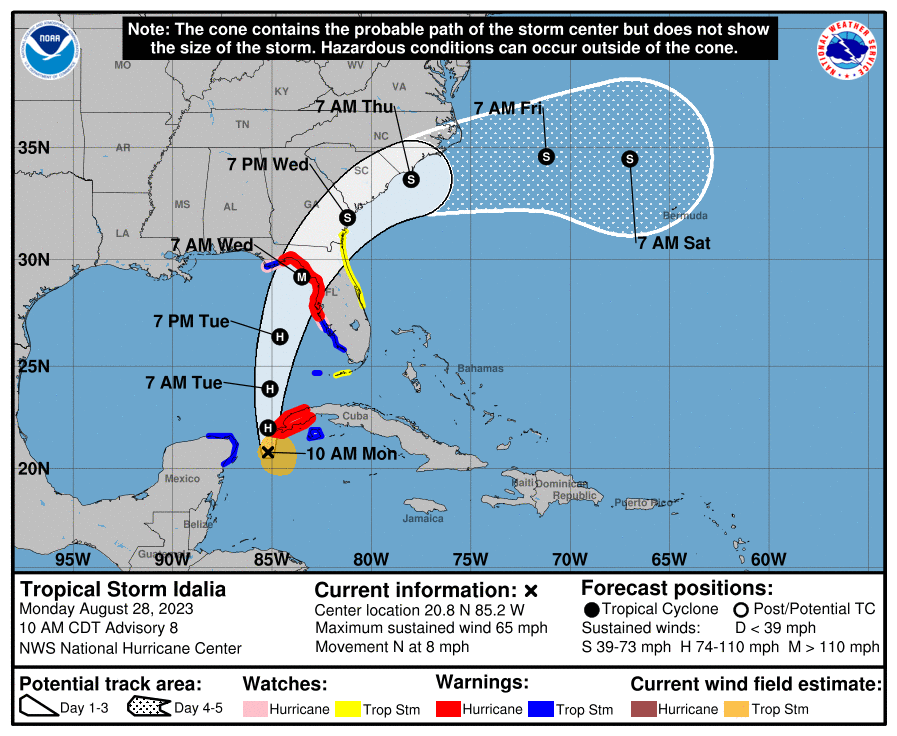
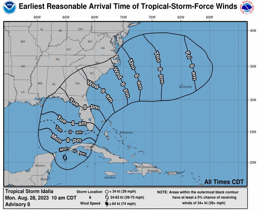

Hurricane Ian, September/October 2022
Please click here for a downloadable version of the Hurricane Ian EOC Updates.
Saturday, 10/1/2022, 1:15pm, Final Update from Chief Drew
Good afternoon:
Southport is able to recover quickly from difficult conditions. Today is a beautiful day, compared to yesterday. The City of Southport is blessed with some amazing professionals. This will be the last summary of conditions from Hurricane IAN. Attached is the official damage assessment from our Building Inspector, Kiley Barefoot and Public Services Director, Tom Stanley. It is rated on the intensity of damage, and the city fared very well from this storm. Parks & Recreation Director, Heather Hemphill has visited all the Parks and Recreation Facilities and properties and has reported to me minor or no damage, except for the Atlantic Street Park and CAMA access point. It has been CLOSED, by Parks & Recreation Director Heather Hemphill. The bulkhead has been destroyed, and it is dangerous. The City Pier, City Dock, and Riverwalk have been re-opened. All city streets are open as well. Chief Treadway & Heather still plan to check all our waterfront properties from the waterside on the Fire Boat Monday Morning, to get a closer look. Chief Coring and his officers have been all over the city checking things as well, he sent an email report out earlier.
The Emergency Operations Center has just closed. It was open from Thursday at 5pm until today at 12 noon. We answered approximately 60-75 phone calls during this time. Most calls into the EOC were weather-related questions, electricity concerns, general questions about safety, and reports of trees or electric lines down. EOC Communications have been shared by email to each of you during the storm, with the latest weather updates and other pertinent information. Communications Director Randy Jones and his team have kept the website and social media sites updated regularly with notices from the EOC. Our fire and EMS crews have answered 34 emergency calls during this event. It was reported to me from the NC Ferry Terminal that yesterday there was a wind gust of 78 mph. The wind gusts that we monitored here at headquarters and the wind gauge at the Waterfront were around 54mph. Then the weather station at the foot of Lord & Bay Street was found offline, due to wind damage. So, we received no further readings from it. The tide on Friday around 11:30am was the largest in conjunction with this storm. Roads were closed, and officers were posted to protect any from driving through the area. All fire and EMS vehicles and equipment have already been washed and maintained today to rid it of any salt spray.
The last I heard, there are about 25 customers without power. Brunswick Electric is working diligently to restore these and will likely be done very soon.
This storm was a great reminder of the teamwork that is evident in Southport. No work-related injuries were reported during this event. I would like to thank our Mayor and Board of Alderman for all their support throughout this event. I pray we can make it through the last day of Hurricane Season (November 30) with no other threats. If anyone needs any further information, please contact me by cell at 910-477-2365.
Thank you again for everyone’s help serving Southport and our citizens.
Respectfully,
Chief Charles A. Drew
Southport Fire Department
910-477-2365
Saturday, 10/1/2022, 9:45am
- All streets are passable
- Little damage was reported
- Basin area clean-up has started
- Many business are working to reopen today
- Oliver’s will reopen at noon, they sustained some water damage inside
- Public works is clearing Bay Street corridor between the Basin and Lord street now.
- Approx 30 residents still without power; BEMC is here working to restore
Friday, 9/30/2022, 8:15pm
A quick update on electrical service. Chief Drew spoke with Director of Public Services, Tom Stanley and we currently have 300 customers without electricity in the city. There were more, but some have been restored. He said that Brunswick Electric is working diligently to restore everyone. Brown Street should be coming back up soon and will restore a big number. Please remain patient as City and BEMC crews will be working through the night to get services restored.
Friday, 9/30/2022, 6:30pm
Good evening:
Please find our final update on Post-Tropical Storm Ian attached. Gusty winds and heavy rain continue over parts of the area, but we expect improving conditions through the evening. Wind gusts of 40-60mph and an additional half inch to inch of rainfall are possible.
Overall, at first glance there is minimal damage through out the city. We have responded this afternoon/evening to about 8-10 trees down resulting in power lines/poles being damaged. Public Services Director Tom Stanley and his crews have been working closely with Brunswick Electric and have done a great job of responding to needs in the city. Chief Coring and the Police Officers have assisted with road closures, damage assessments, and many other law related calls. All roads have been cleared and are now open. There are 3 additional police officers that will be on patrol this evening due to the power outages and will do an additional damage assessment in the morning. Chief Coring will report any finding on tomorrow. The fire & EMS crews have answered 24 emergency calls since the State of Emergency was enacted yesterday at 5pm. The EOC has been manned for over 24 hours now, with a minimal amount of phone calls, most were questions about the storm or power outages, assistance was offered to all our citizens.
I would suggest that the Building Inspector, Kiley Barefoot do a final damage assessment this weekend. I will line up for the Parks and Recreation Director, Heather Hemphill to get with Chief Treadway on Monday to take the fire boat out to inspect the City Dock, Pier, Riverwalk, Kingsley Park, the Waterfront Park Bulkhead, and other City Waterfront properties from the water.
If anyone has seen specific damages in their neighborhoods that we have not noticed, let me know so I can log it into WEB EOC activity report. This will ensure that it is reported to the County and State partners.
I appreciate the support from the Mayor and Board Members during this storm.
Thank you for all the hard work and collaboration in response to Hurricane Ian.
Chief Drew
Southport Fire Department
910-477-2365
Friday, 9/30/2022, 4:20pm
From Chief Drew: The Waterfront has been taking a beating for the last hour or so. A large tree on River Drive has taken out several power poles, and the electricity is down on River Drive and Cape Fear Drive. The structure fire response with Oak Island has been cleared. When the storm is clear, we will begin damage assessments. If you know of damages anywhere, please email cdrew@cityofsouthport.com so we can keep track of damages. Hurricane Ian made landfall in SC at 2:05pm and the forward speed has increased.
Friday, 9/30/2022, 2:50pm
Mayor Hatem and Chief Drew participated in the 2pm Conference Call with Brunswick County. Here are the takeaways:
National Weather Service
- Heavy Rain on the North and West side of the storm
- Center of IAN is close to Georgetown, SC
- High Tide is slowly starting to recede
- Wind Gusts have been around 40 – 60 mph in Brunswick County so far
- Several more hours and we should be in the clear.
- The High Tide tonight should not be as bad as it was this morning.
Our Report to the County:
- Yacht Basin Drive flooded and closed
- Bay Street near Lord flooded and closed
- Brunswick Street flooded and closed
- Short Street closed, to stop residents from getting in flood waters on Brunswick Street
- 3 Trees down, Bay Street, 812 Caswell Avenue, and 108 Hankins Drive. All cleared from Roadway by Public Works or Southport Fire.
- State of Emergency will be lifted at 12 noon tomorrow, if all clear is given.
- Ponding on side streets, use caution.
Friday, 9/30/2022, 12:50pm
Tornado Watch issued for Eastern North Carolina until 10pm.
Friday, 9/30/2022, 12:27pm
Tornado Warning issued for Brunswick County until 1pm.
Friday, 9/30/2022, 11:40am
Brief Summary of Fire Responses:
- Elevator Stuck
- Fire Alarm Call at Deep Point Marina
- 3 Medical Emergencies ( 2 requiring transport)
- Tree Down on Caswell Avenue
- Tree Down on Hankins Drive
Streets Flooded:
- Bay and Lord
- Bay and Caswell
- Yacht Basin Drive between Short Street & the Marina
- Yacht Basin from Frying Pan to Fishy Fishy
Tornado Watch in Effect until 10pm.
Friday, 9/30/2022, 11:30am
ROAD CLOSURE: The Yacht Basin loop roads have been closed due to flooding.
- W. Moore Street
- Yacht Basin Drive
- Caswell Avenue
- W. Bay Street
Please avoid this area.

Friday, 9/30/2022, 11:15am


Friday, 9/30/2022, 9:00am
From National Weather Service Wilmington: Dangerous storm surge is expected across coastal areas of northeast SC, especially around high tide today (~11:15am). Surge inundation of 4-7 ft is expected across NE SC coastline, with 3-5 ft for Brunswick coast & 2-4 ft north of Cape Fear.

Thursday, 9/29/2022, 5:00pm
Good afternoon:
The City of Southport is under a State of Emergency. The Mayor signed the proclamation at 5pm, September 29, 2022. The City of Southport has been placed under a HURRICANE WARNING as of 5pm also. I was contacted earlier by the City Manager, who received notification from Brunswick County that the Storm Surge for our immediate area will increase as much as 6 feet. As I have further information, I will pass it along to each of you.
Thank you,
Chief Drew
Southport Fire Department
910-477-2365
Thursday, 9/29/2022, 4:00pm
An update from EOC Incident Commander, Fire Chief Charles Drew:
Good afternoon:
The city staff had a conference call with our county partners at 2pm and had an emergency operation meeting afterwards. Here is a summary of the meeting:
- National Weather Service gave a briefing and stated the 5pm advisory would shed more light on any shifts in the track of the storm. If the storm tracks more Northeast, it will change predictions for our area.
- Currently they are forecasting 55-65 mph wind gusts in Southport with a storm surge up to 4 feet. 4-6 inches of rain and a danger of tornadoes Friday AM.
- The center of the storm is predicted with a 50-mile margin, this could change our forecast
Brunswick County – No State of Emergency, no evacuation orders, no shelters are opening. They will have an internal EOC operation, and a WEB EOC Event has been created.
City of Southport Meeting:
- FEMA Forms were distributed to all departments. Forms will be used documenting hours worked and any equipment used during the event.
- City Offices will be closed Friday for all non-essential employees.
- City Parks have been secured; swings have been removed. City Pier and City Dock will be closed at 5pm today, until the storm clears.
- City Vehicles have all been fueled, all generators have been checked and fueled. All portable equipment has been checked and fueled.
- BEMC will have bucket trucks on standby for the city electric system.
- The Police Department will have extra staffing, their High Clearance Vehicle has been stationed at Fire Headquarters if needed.
- Public Works will have crews on standby if needed.
- A partial EOC will be open and running at Fire Headquarters beginning at 8am Friday, the number is 910-457-7915. The EOC will update WEB EOC for resource needs from the County or State.
- Weaknesses in the city infrastructure were discussed. Identified were 2 lift stations and Bay Street between Lord and Caswell. If a generator is needed for the lift stations, the one at the downtown substation will be relocated to help.
- Fire and EMS Crews will be on standby at Headquarters if needed.
- All Water Rescue Equipment has been serviced, fueled, and checked if needed for swift water rescue needs.
- Contact is being made with Dosher Hospital, Southport Rehabilitation Center, and Terra Bella for any needs or resources.
If anyone has questions or concerns, please feel free to contact me at 910-477-2365.
Please stay safe!
Chief Drew
Southport Fire Department
910-477-2365

Please do NOT use this form in cases of emergency.
Do you have general questions about how to prepare for emergencies?
Contact us!
Contact Form
City Hall & Information | 910-457-7900
Emergency | 9-1-1
Non-Emergency |
- Police: 910-457-7911, Fax: 910-457-0302
- Fire: 910-457-7915 or 910-457-7911
- EMS: 910-457-7916, Fax: 910-457-7908