
")


Staying connected with the community is a priority for the City of Southport. Our community notification system SouthportCONNECTED! gives residents, businesses, and visitors 24/7 access to important emergency alerts as well as general community updates.
SouthportCONNECTED! is built on the Onsolve CodeRED communication system to ensure efficient, secure messaging via phone, email, and text.
Why CONNECT?
There are several benefits to enrolling in the SouthportCONNECTED! Community Notification System.
- During a crisis, real-time updates can provide life-saving instructions and information.
- Notifications are on the go with you. You can receive important alerts and updates directly to your cell phone, home phone, text, or email.
- You’ll receive Southport-specific alerts and updates on both emergency and non-emergency topics that matter to our community.
- You’ll be notified when there are Public Services announcements or emergency situations that specifically impact your home or business location.
- Your personal data is secure in the Onsolve CodeRED system, which is used nation-wide by emergency services teams and municipalities.

 If you’re a local business owner, we want to CONNECT with you!

How is the City of Southport using CodeRED to connect with the community?
The City of Southport wants to provide residents, local business owners, visitors, and employees with the most relevant information exactly when it’s needed. SouthportCONNECTED! allows us to send out emergency alerts and to stay in touch with community updates.
What methods of communication can I choose to receive Southport Connected! notifications?
So many choices! You may receive emergency alerts and notification from the City of Southport via cell phone, landline phone, text, or email. Or all of the above!
You choose what works for you.
What if I live outside of Southport?
Do you live in St, James, Boiling Springs, Oak Island, or other communities outside of the City of Southport?
The CodeRED system that SouthportCONNECTED! is built on will only allow you to register directly for this tool if you live within Southport city limits (i.e. you pay taxes to the City of Southport.) One reason for this is to ensure that everyone is following their local emergency services alerts that apply specifically to your physical location.
However – if you’d like to sign up to receive Southport Community Updates and other non-emergency information, we’d love to add you to our distribution list! Just complete the form below and we’ll get you CONNECTED!
I am already enrolled in ReadyBrunswick with Brunswick County. Is this the same thing?
The SouthportCONNECTED! Community Notification System is not connected to the ReadyBrunswick program. You will need to sign up for this Southport-specific tool even if you already have enrolled in the County program.
What phone numbers should I put in my contact list to recognize SouthportCONNECTED! notifications?
How will you know when a message is sent from the Southport Connected! application? A message will have one of the following caller ID numbers:
866-419- 5000 for Emergencies
855-969-4636 for Community Updates, Covid Updates, Community Events, and other non-emergency information
800-566-9780 for Severe Weather Warning Alerts
You also have the ability to customize your caller ID number to any desired locally identifiable number. We suggest that residents program these numbers into their cell phone as a “new contact” and use “SouthportCONNECTED!” as the contact name. If you need to replay the message received, you can dial this number and listen to the message again in its entirety.
I missed the last SouthportCONNECTED! notification. How do I find the information?
Redial the number that you received the notification from and the last message will be replayed for you.
I’ve enrolled in SouthportCONNECTED! (CodeRED). Do I need to sign up for the CodeRED mobile alert app separately?
Yes.
For more information on the CodeRED Mobile Alert app for iOS and Android, please see the “Mobile app” tab on this page.

Click on each image below to learn more about available resources before, during, and after an emergency.

Click on each image below to learn more about available resources before, during, and after an emergency.
2023 NOAA Atlantic Hurricane Outlook – Updated August 10
The official start of the Atlantic hurricane season is June 1 and runs through November 30.

The updated 2023 Atlantic hurricane season probability and number of named storms. (Image credit: NOAA)

The 2023 Atlantic tropical cyclone names selected by the World Meteorological Organization. (Image credit: NOAA)
2023 Southport Hurricane Expo
Hurricane Expo Presenter Contact Information
- Hannah Patrick, WWAY Evening Anchor: Email | (910) 763-0979
- Jake Eichstädt, WWAY Sports Anchor: Email | (910) 763-0979
- Bonnie Therrien, City Manager: Email | (910) 457-7900 x 1006
- Chief Charles Drew, Fire Department: Email | (910) 457-7915
- Chief Todd Coring, Police Department: Email | (910) 457-7913
- Tom Stanley, Public Services Director: Email | (910) 457-7935
- Ellie Pittenger, Public Services Electrical Superintendent: Email | (910) 457-7938
- Dorrie Dutton, Assistant City Manager/City Clerk: Email | (910) 457-7900 x 1010
- Kate Marshall, Animal Protective Services Director: Email | (910) 477-1486
- Chief Ralph Treadway, Fire/EMS Battalion Chief: Email | (910) 457-7915
- Captain Paul Homick, Fire Department: Email | (910) 457-7915
- Travis Henley, Development Services Director: Email | (910) 457-7900 x 1008
- Tori Deviney, Permit Technician: Email | (910) 457-7925
- Fire Marshal Madison Drew, Fire Department: Email | (910) 457-7915
- ChyAnn Ketchum, Public Information Officer: Email | (910) 457-7927 x 1040


Click on each image below to learn more about available resources before, during, and after an emergency.

Click on each button or image below to learn more about available resources before, during, and after an emergency.

Click on each image below to learn more about available resources before, during, and after an emergency.


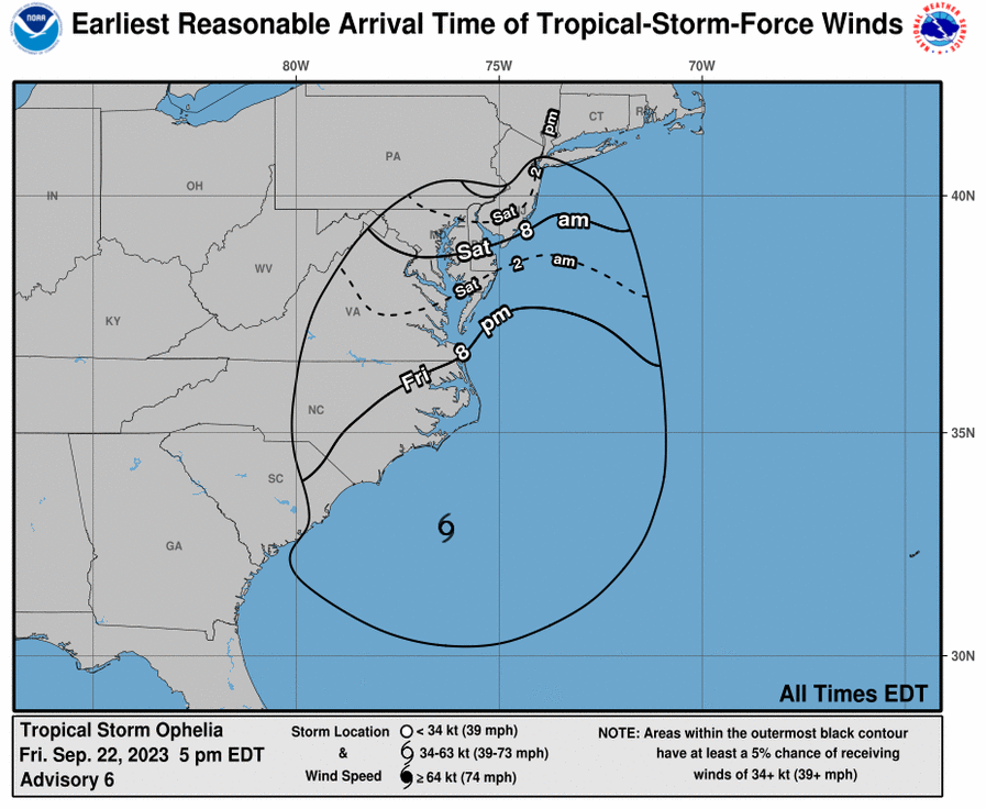
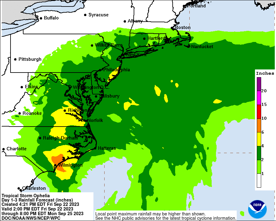
Tropical Storm Ophelia, 2023
Friday, September 22, 2023, 6:30pm
Tropical Storm Ophelia will continue to move toward the NC coast tonight bringing a variety of impacts to the area.
- Conditions are expected to gradually improve during Saturday as Ophelia moves away from the area towards the north.
- A quick summary of impacts that are expected across northeast SC & southeast NC include:
- Heavy rainfall with amounts of 2 to 4 inches across portions of southeast NC with 4 to 8 inch amounts across Pender, New Hanover, and eastern Brunswick Counties
- Some storm surge/coastal flooding (1-3’ inundation above ground level, especially north of Cape Fear)
- Strong winds of 20 to 30 mph, with gusts to 40 to 50 mph especially along the coastal areas around Cape Fear northward to Surf City, NC (higher gusts are expected just off the coast).
- Strong rip currents and very rough surf
- Hazardous maritime conditions with large/steep seas
Friday, September 22, 2023, 5:00pm
Tropical Storm Ophelia has formed.
Tropical Storm Ophelia will continue to move toward the NC coast tonight bringing a variety of impacts to the area.
- Conditions are expected to gradually improve during Saturday as Ophelia moves away from the area towards the north.
- A quick summary of impacts that are expected across northeast SC & southeast NC include:
- Heavy rainfall with amounts of 3 to 6 inches across portions of southeast NC with 6 to 8 inch amounts across Pender, New Hanover, and eastern Brunswick Counties
- Some storm surge/coastal flooding (1-3’ inundation above ground level, especially north of Cape Fear)
- Strong winds of 20 to 30 mph, with gusts to 40 to 50 mph especially along the coastal areas around Cape Fear northward to Surf City, NC (higher gusts are expected just off the coast).
- Strong rip currents and very rough surf
- Hazardous maritime conditions with large/steep seas

Hurricane Idalia, 2023
Wednesday, August 31, 12:00pm
After reports from the Emergency Operations Team, there is little to no damage from the effects of Idalia. The following reports have come in:
Incident Commander:
- Very few calls into the EOC during the storm.
- The EMS crew had 12 medical emergency calls since the opening of the EOC.
- The Fire crew had 5 emergency calls during the opening of the EOC.
- 1 residential structure fire.
- 1 vehicle with 2 occupants trapped in floodwater
- The EOC was partially open, and manned by me, Chief Coring, and City Manager Therrien.
- Communication was established with Tom Stanley, for Public Work Needs.
- Went through 4 tornado warnings, during the storm.
- Kept a constant check on electric outages during the storm on the BEMC website.
Police:
- Officers checked the city overnight and this morning.
- No issues to report.
- The road due to flooding East Leonard Street between Jabbertown & Firefly @ 0130, has since been reopened.
- The stoplight at Moore & Howe has been flashing, this was reported to DOT.
Communications/Tourism:
- The director completed an interior review of Ft Johnston, the Community Building, and the Indian Trail Meeting Hall.
Public Works:
- Erosion on 200 block of Bay Street – Minimal.
- Sidewalk on 200 Block of Bay Street – Repairs will be needed, but very minimal.
- Minimal debris on roads.
Parks & Recreation:
- Minimal Damages to all parks – Leaf & Debris.
- All Buildings appear fine.
I & Chief Coring participated in the Brunswick County Conference Call at 10 a.m. this morning. No needs or resources were requested. I made a report to the county on our damage assessment. The Southport EOC will close at 12 noon today, and we will resume normal operations. I would like to meet with all department heads for a debriefing on the entirety of the storm at 0830 hours, Friday, September 01, 2023, in the EOC. During this time, we can discuss our strengths and weaknesses, and any improvements we need for future storm-related incidents.
I would like to personally thank City Manager Therrien, She is the first city manager that I have worked with since being fire chief and has stayed the entire time with us in the EOC! Also, Chief Coring and Director Tom Stanley and their employees have done a great job during this storm. Public Works and the Police Department were here and responsive during the whole storm! Lastly, the fire and EMS crews were such an asset to the whole operation. They have answered calls, cooked, and fed personnel, and kept the station neat and clean. The City of Southport has a great team of employees! Thank you to everyone who helped, assisted, worked, or supported staff during this event.
Respectfully,
Chief Charles A. Drew
Fire Chief/Incident Commander
City of Southport
Tuesday, August 30, 8:30pm
Tropical Storm Idalia will move up the Carolina coast tonight into Thursday. The main impact will be heavy rain and localized flooding. Isolated tornadoes are also expected, mainly along the coast. A Tornado watch has been issued for Southport and nearby local areas until 4:00 a.m.
Tropical storm-force winds may cause downed trees and power outages. The highest chance of wind-related impacts will be along the coast. Minor storm surge is also possible primarily around high tides this evening and Thursday. Gusty winds will continue as Idalia exits the area. Downed trees and power lines are possible due to the winds and saturated soils on Thursday.
Tuesday, August 30, 2:10pm
The City of Southport Emergency Operations Team met this morning at 0930 in the EOC. The following is a summary of the meeting:
- Incident Commander:
- Weather Update and Briefing held.
- Fire/EMS crews are all on standby.
- Supplies/Food for storm preparations are complete.
- Essential employee list was completed by City Manager yesterday.
- All our partners have been contacted and established lines of communication with, BEMC, Dosher Hospital, Southport Rehab, Terra Bella, Brunswick County Emergency Management, & NC Emergency Management.
- WEB EOC is up and running.
- City Manager:
- Closing City Hall at 12 noon today, re-open 12 noon tomorrow.
- Make sure all vehicles are fueled.
- With the partial EOC opening, will only need Fire, Police, City Manager, and Public Works Director.
- Any trash collection for Thursday, will be picked up on Saturday.
- Police:
- High Clearance Vehicle is ready and in place.
- Staff is on standby.
- Parks & Recreation:
- Bus/Van gassed up and ready if needed for transports or evacuation helps.
- They will have children at P&R Building until 2pm today.
- Programs/Activities closed Thursday.
- Requested for Public Works to secure swings and trash cans.
- Mayor Hatem:
- His main concern is the Public Health and Safety of the employees, citizens, and visitors.
- Keep communications open with briefings and press releases.
- Southport is in good hands, with experienced employees.
- Public Works Director:
- Staff is ready and on standby.
- EOC will contact Tom if things are needed.
- City Engineers are on standby to assist Tom if needed.
- Assistant City Manager/Clerk to the Board:
- FEMA forms will be emailed to all department heads at the close of this meeting.
- FEMA has 5 different forms, Dorrie has condensed them into 2 main forms we will use to track expenses, calls, and employee hours.
- State of Emergency has been prepared and will be emailed to Mayor, Incident Commander, and City Manager before leaving today, if needed.
- Planning/Building Inspections:
- Staff is ready if needed to do Post-Storm assessment.
- Community Relations/Tourism:
- Visitor’s Center is closed today and tomorrow.
- Community Building is closed.
- Animal Protective Services:
- Operational.
- Public Information Officer:
- Leaving for out-of-town trip at 7:30pm this evening.
- Will have laptop and city cell phone if needed.
- Assistant PIO is prepared as the back up and has been trained.
- Leaving for out-of-town trip at 7:30pm this evening.
Immediately following the City’s meeting, the team participated in a Brunswick County Conference Call with all municipalities and county partners.
The City of Southport remains very vigilant and aware of this storm. I am watching every briefing and update with precision, and if there are any significant changes, I will update you as soon as possible. Non-essential employees have been released, and essential staff is ready and on standby. If citizens have any needs, please have them call 910-457-7915.
Respectfully,
Chief Charles A. Drew
Incident Commander
City of Southport
Tuesday, August 30, 12:55pm
What has changed:
- Tropical Storm Watches upgraded to Tropical Storm Warnings
- Tornado Risk has increased
- New river flood updates
- Wind gusts increased across the adjacent coastal waters
Tuesday, August 30, 10:25am
- The tornado risk for portions of northeast SC and southeast NC has been increased to an Enhanced Risk (3 of 5).
- The risk will increase as bands of storms move onshore, especially this afternoon and evening.
- A Tornado Watch may be needed to highlight this threat
- Be prepared to seek shelter if Tornado Warnings are issued for your area

Tuesday, August 30, 9:30am
What has changed:
- Tropical Storm Watches and Warnings expanded
- High Surf Advisory and Coastal Flood Warning now in effect
- Rainfall totals have been increased
- Increased river flood threat
- Expected wind speeds have been increased
Idalia will make landfall along the west coast of FL this morning. The storm will move
across southeast Georgia later today to the SC coast late tonight.
- It is possible that Idalia could be a strong tropical storm or hurricane early Thursday morning as it moves near the SC coast.
- Impacts will begin to increase across northeast SC and southeast NC later today, through tonight, and Thursday. These impacts include:
- Heavy rainfall and dangerous flash flooding
- A few tornadoes and waterspouts
- Some storm surge/coastal flooding
- Gusty winds exceeding 40 mph (tropical storm force)
- Strong rip currents from Hurricane Franklin off to the east and from Idalia
- Hazardous maritime conditions
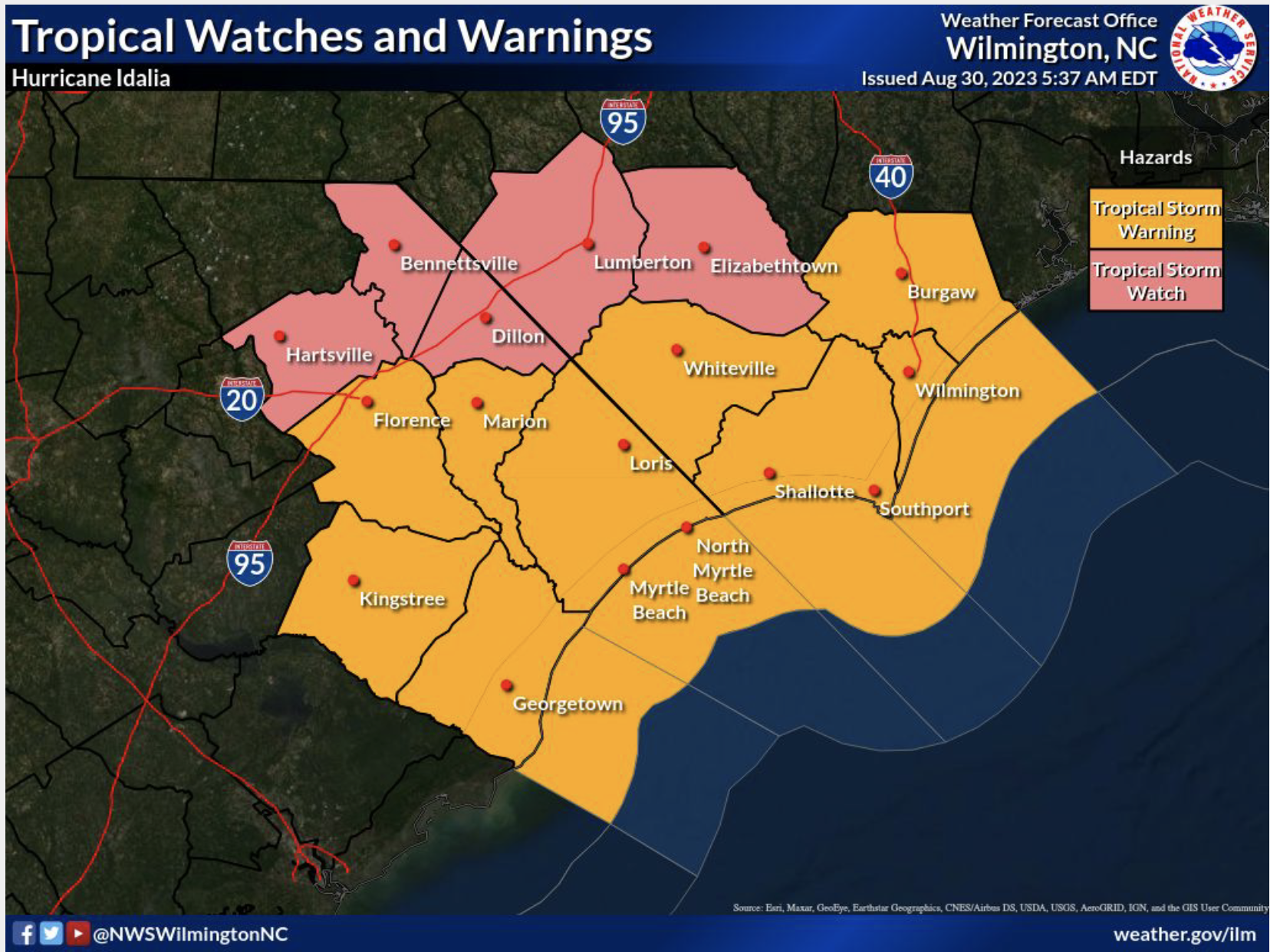


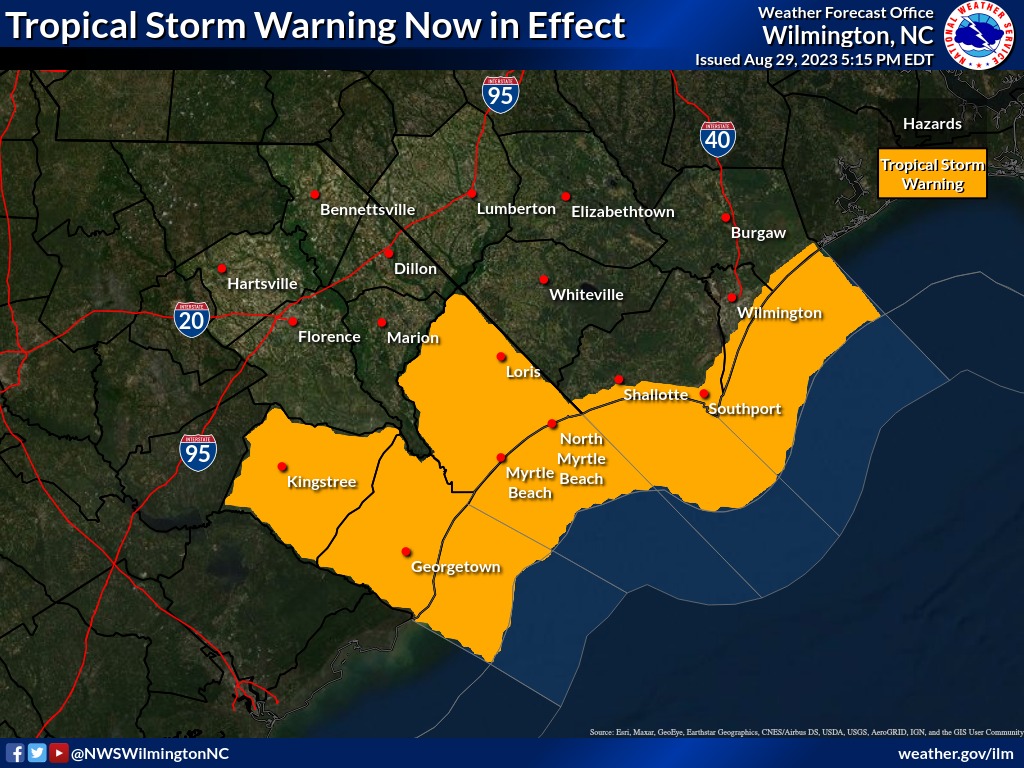
Tuesday, August 29, 2023, 7:45pm
What has changed:
- Tropical Storm Warning now in effect for Williamsburg, Georgetown, Horry, Coastal Brunswick, Coastal New Hanover, & Coastal Pender Counties
- Tropical Storm Warning for coastal waters from Surf City to South Santee River out 20 nautical miles.
- Flash Flood Watch for Southeast North Carolina and Northeast South Carolina Wednesday Afternoon through Thursday
- Added Mostly Likely Time of Arrival for Tropical Storm Winds.
The latest briefing can be found here.

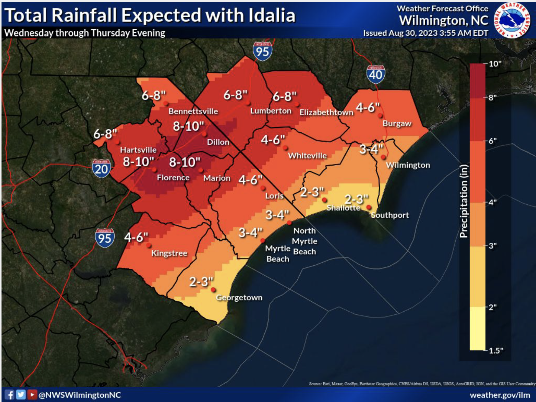
Tuesday, August 29, 2023 4:30pm
As preparations continue, the concern for Idalia is a bit greater for Southport now than it was late yesterday, though presently the estimated winds expected for Southeastern NC are 30 miles per hour (plus/minus) with gusts up to 60 miles per hour (plus/minus). The full moon and King Tide that is going to impact us late Wednesday and Thursday could also add an additional three feet of water.
Unusually heavy rain will potentially cause further problems. Due to the expected increase of the amount of water, residents should prepare accordingly. These preparations would include consideration of elevating or removing items in garages and under homes. Don’t forget golf carts, electric mowers, and other electrical devices that may cause fires if subjected to water. Also, please monitor the streets, as some may become impassible. Stay in your homes, if possible. If you do have to leave for any reason and encounter flooding, remember to “turn around, don’t drown.”
Tuesday, August 29, 2023, 12:00pm
The City of Southport Emergency Operations Team met at 0830 this morning. Here is a synopsis of the meeting:
- An updated weather briefing was given.
- All city departments reported on current resources and situational awareness of the upcoming storm event.
- FEMA forms and documentation was discussed.
- Contact with all our partners have been completed to include, BEMC, Dosher Hospital, Southport Rehabilitation Center, and Terra Bella Assisted Living.
- All city vehicles and apparatus has been checked, maintained, and fueled.
- All city generators have been checked, maintained, and fueled.
- Extra diesel fuel is stored at the City Garage if needed.
- All essential employees have been placed on standby notification.
- WEB EOC has been checked and is current.
- Continuously monitoring the National Hurricane Center Forecast for any changes.
- State of Emergency is ready to go, if needed.
- Communications have been established with Brunswick County Emergency Management and the State of NC Emergency Management.
- Department Heads are beginning to track expenses, employee hours, and any special needs.
- There may be some interruption of trash collection, we will know further on this tomorrow.
At the meeting, the following Protective Actions have been taken:
- A partial EOC will be activated at 4pm on Wednesday.
- All city parks, city dock, city pier, and riverwalk will be closed at 12 noon on Wednesday.
- All city meetings/events have been canceled for Wednesday & Thursday.
Respectfully,
Charles A. Drew
Fire Chief/Incident Commander
City of Southport
Tuesday, August 29, 2023, 10:15am
Due to impending inclement weather from Hurricane Idalia, please take note of the following City of Southport cancellations and closures:
⚠️ City Pier, City Dock, Riverwalk, and all City Parks (including the Dog Park), will be closing at 4:00pm on Wednesday, August 30th.
⚠️ The August 30th Historic Preservation Commission meeting is cancelled and will be rescheduled.
⚠️ The Fort Johnston-Southport Visitors’ Center & Museum will be closed on Thursday, August 31st.
⚠️ All City Parks & Recreation buildings and activities (including Open Gym) are cancelled for Thursday, August 31st.
⚠️ The August 31st Board of Aldermen Special Meeting and Homelessness Forum is cancelled and will be rescheduled.
⚠️ The August 31st Concert in the Park has been cancelled and will not be rescheduled.
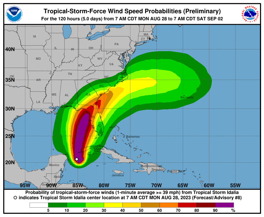
Tuesday, August 29, 2023, 8:30am
NOAA Idalia Resource Page can be found here.
What has changed:
- Idalia is now a hurricane
- Tornado Risk has increased
- Included peak sustained and peak gust swath graphics
- Included slide on dangerous rip currents and rough surf
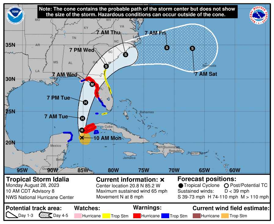
Monday, August 28, 2023, 11:30am
National Weather Service Idalia Briefing can be found here. Key points include:
- Idalia is expected to become a hurricane today while moving north across the northwest Caribbean Sea and eastern Gulf of Mexico. After landfall in Florida late Tuesday night or early Wednesday, Idalia should move near the Georgia and South Carolina coast Wednesday into Thursday.
- Depending on the track Idalia takes, potential impacts include:
- Heavy rainfall, potentially causing flooding
- Gusty winds exceeding 39 mph (tropical storm force)
- Rip currents at the beaches (Strong rip currents expected from Franklin too)
- Isolated tornadoes or waterspouts
- Large seas across the coastal waters
NOAA Idalia Resource Page can be found here.

Hurricane Ian, 2022
Please click here for a downloadable version of the Hurricane Ian EOC Updates.
Saturday, 10/1/2022, 1:15pm, Final Update from Chief Drew
Good afternoon:
Southport is able to recover quickly from difficult conditions. Today is a beautiful day, compared to yesterday. The City of Southport is blessed with some amazing professionals. This will be the last summary of conditions from Hurricane IAN. Attached is the official damage assessment from our Building Inspector, Kiley Barefoot and Public Services Director, Tom Stanley. It is rated on the intensity of damage, and the city fared very well from this storm. Parks & Recreation Director, Heather Hemphill has visited all the Parks and Recreation Facilities and properties and has reported to me minor or no damage, except for the Atlantic Street Park and CAMA access point. It has been CLOSED, by Parks & Recreation Director Heather Hemphill. The bulkhead has been destroyed, and it is dangerous. The City Pier, City Dock, and Riverwalk have been re-opened. All city streets are open as well. Chief Treadway & Heather still plan to check all our waterfront properties from the waterside on the Fire Boat Monday Morning, to get a closer look. Chief Coring and his officers have been all over the city checking things as well, he sent an email report out earlier.
The Emergency Operations Center has just closed. It was open from Thursday at 5pm until today at 12 noon. We answered approximately 60-75 phone calls during this time. Most calls into the EOC were weather-related questions, electricity concerns, general questions about safety, and reports of trees or electric lines down. EOC Communications have been shared by email to each of you during the storm, with the latest weather updates and other pertinent information. Communications Director Randy Jones and his team have kept the website and social media sites updated regularly with notices from the EOC. Our fire and EMS crews have answered 34 emergency calls during this event. It was reported to me from the NC Ferry Terminal that yesterday there was a wind gust of 78 mph. The wind gusts that we monitored here at headquarters and the wind gauge at the Waterfront were around 54mph. Then the weather station at the foot of Lord & Bay Street was found offline, due to wind damage. So, we received no further readings from it. The tide on Friday around 11:30am was the largest in conjunction with this storm. Roads were closed, and officers were posted to protect any from driving through the area. All fire and EMS vehicles and equipment have already been washed and maintained today to rid it of any salt spray.
The last I heard, there are about 25 customers without power. Brunswick Electric is working diligently to restore these and will likely be done very soon.
This storm was a great reminder of the teamwork that is evident in Southport. No work-related injuries were reported during this event. I would like to thank our Mayor and Board of Alderman for all their support throughout this event. I pray we can make it through the last day of Hurricane Season (November 30) with no other threats. If anyone needs any further information, please contact me by cell at 910-477-2365.
Thank you again for everyone’s help serving Southport and our citizens.
Respectfully,
Chief Charles A. Drew
Southport Fire Department
910-477-2365
Saturday, 10/1/2022, 9:45am
- All streets are passable
- Little damage was reported
- Basin area clean-up has started
- Many business are working to reopen today
- Oliver’s will reopen at noon, they sustained some water damage inside
- Public works is clearing Bay Street corridor between the Basin and Lord street now.
- Approx 30 residents still without power; BEMC is here working to restore
Friday, 9/30/2022, 8:15pm
A quick update on electrical service. Chief Drew spoke with Director of Public Services, Tom Stanley and we currently have 300 customers without electricity in the city. There were more, but some have been restored. He said that Brunswick Electric is working diligently to restore everyone. Brown Street should be coming back up soon and will restore a big number. Please remain patient as City and BEMC crews will be working through the night to get services restored.
Friday, 9/30/2022, 6:30pm
Good evening:
Please find our final update on Post-Tropical Storm Ian attached. Gusty winds and heavy rain continue over parts of the area, but we expect improving conditions through the evening. Wind gusts of 40-60mph and an additional half inch to inch of rainfall are possible.
Overall, at first glance there is minimal damage through out the city. We have responded this afternoon/evening to about 8-10 trees down resulting in power lines/poles being damaged. Public Services Director Tom Stanley and his crews have been working closely with Brunswick Electric and have done a great job of responding to needs in the city. Chief Coring and the Police Officers have assisted with road closures, damage assessments, and many other law related calls. All roads have been cleared and are now open. There are 3 additional police officers that will be on patrol this evening due to the power outages and will do an additional damage assessment in the morning. Chief Coring will report any finding on tomorrow. The fire & EMS crews have answered 24 emergency calls since the State of Emergency was enacted yesterday at 5pm. The EOC has been manned for over 24 hours now, with a minimal amount of phone calls, most were questions about the storm or power outages, assistance was offered to all our citizens.
I would suggest that the Building Inspector, Kiley Barefoot do a final damage assessment this weekend. I will line up for the Parks and Recreation Director, Heather Hemphill to get with Chief Treadway on Monday to take the fire boat out to inspect the City Dock, Pier, Riverwalk, Kingsley Park, the Waterfront Park Bulkhead, and other City Waterfront properties from the water.
If anyone has seen specific damages in their neighborhoods that we have not noticed, let me know so I can log it into WEB EOC activity report. This will ensure that it is reported to the County and State partners.
I appreciate the support from the Mayor and Board Members during this storm.
Thank you for all the hard work and collaboration in response to Hurricane Ian.
Chief Drew
Southport Fire Department
910-477-2365
Friday, 9/30/2022, 4:20pm
From Chief Drew: The Waterfront has been taking a beating for the last hour or so. A large tree on River Drive has taken out several power poles, and the electricity is down on River Drive and Cape Fear Drive. The structure fire response with Oak Island has been cleared. When the storm is clear, we will begin damage assessments. If you know of damages anywhere, please email [email protected] so we can keep track of damages. Hurricane Ian made landfall in SC at 2:05pm and the forward speed has increased.
Friday, 9/30/2022, 2:50pm
Mayor Hatem and Chief Drew participated in the 2pm Conference Call with Brunswick County. Here are the takeaways:
National Weather Service
- Heavy Rain on the North and West side of the storm
- Center of IAN is close to Georgetown, SC
- High Tide is slowly starting to recede
- Wind Gusts have been around 40 – 60 mph in Brunswick County so far
- Several more hours and we should be in the clear.
- The High Tide tonight should not be as bad as it was this morning.
Our Report to the County:
- Yacht Basin Drive flooded and closed
- Bay Street near Lord flooded and closed
- Brunswick Street flooded and closed
- Short Street closed, to stop residents from getting in flood waters on Brunswick Street
- 3 Trees down, Bay Street, 812 Caswell Avenue, and 108 Hankins Drive. All cleared from Roadway by Public Works or Southport Fire.
- State of Emergency will be lifted at 12 noon tomorrow, if all clear is given.
- Ponding on side streets, use caution.
Friday, 9/30/2022, 12:50pm
Tornado Watch issued for Eastern North Carolina until 10pm.
Friday, 9/30/2022, 12:27pm
Tornado Warning issued for Brunswick County until 1pm.
Friday, 9/30/2022, 11:40am
Brief Summary of Fire Responses:
- Elevator Stuck
- Fire Alarm Call at Deep Point Marina
- 3 Medical Emergencies ( 2 requiring transport)
- Tree Down on Caswell Avenue
- Tree Down on Hankins Drive
Streets Flooded:
- Bay and Lord
- Bay and Caswell
- Yacht Basin Drive between Short Street & the Marina
- Yacht Basin from Frying Pan to Fishy Fishy
Tornado Watch in Effect until 10pm.
Friday, 9/30/2022, 11:30am
ROAD CLOSURE: The Yacht Basin loop roads have been closed due to flooding.
- W. Moore Street
- Yacht Basin Drive
- Caswell Avenue
- W. Bay Street
Please avoid this area.

Friday, 9/30/2022, 11:15am

Friday, 9/30/2022, 9:00am
From National Weather Service Wilmington: Dangerous storm surge is expected across coastal areas of northeast SC, especially around high tide today (~11:15am). Surge inundation of 4-7 ft is expected across NE SC coastline, with 3-5 ft for Brunswick coast & 2-4 ft north of Cape Fear.

Thursday, 9/29/2022, 5:00pm
Good afternoon:
The City of Southport is under a State of Emergency. The Mayor signed the proclamation at 5pm, September 29, 2022. The City of Southport has been placed under a HURRICANE WARNING as of 5pm also. I was contacted earlier by the City Manager, who received notification from Brunswick County that the Storm Surge for our immediate area will increase as much as 6 feet. As I have further information, I will pass it along to each of you.
Thank you,
Chief Drew
Southport Fire Department
910-477-2365
Thursday, 9/29/2022, 4:00pm
An update from EOC Incident Commander, Fire Chief Charles Drew:
Good afternoon:
The city staff had a conference call with our county partners at 2pm and had an emergency operation meeting afterwards. Here is a summary of the meeting:
- National Weather Service gave a briefing and stated the 5pm advisory would shed more light on any shifts in the track of the storm. If the storm tracks more Northeast, it will change predictions for our area.
- Currently they are forecasting 55-65 mph wind gusts in Southport with a storm surge up to 4 feet. 4-6 inches of rain and a danger of tornadoes Friday AM.
- The center of the storm is predicted with a 50-mile margin, this could change our forecast
Brunswick County – No State of Emergency, no evacuation orders, no shelters are opening. They will have an internal EOC operation, and a WEB EOC Event has been created.
City of Southport Meeting:
- FEMA Forms were distributed to all departments. Forms will be used documenting hours worked and any equipment used during the event.
- City Offices will be closed Friday for all non-essential employees.
- City Parks have been secured; swings have been removed. City Pier and City Dock will be closed at 5pm today, until the storm clears.
- City Vehicles have all been fueled, all generators have been checked and fueled. All portable equipment has been checked and fueled.
- BEMC will have bucket trucks on standby for the city electric system.
- The Police Department will have extra staffing, their High Clearance Vehicle has been stationed at Fire Headquarters if needed.
- Public Works will have crews on standby if needed.
- A partial EOC will be open and running at Fire Headquarters beginning at 8am Friday, the number is 910-457-7915. The EOC will update WEB EOC for resource needs from the County or State.
- Weaknesses in the city infrastructure were discussed. Identified were 2 lift stations and Bay Street between Lord and Caswell. If a generator is needed for the lift stations, the one at the downtown substation will be relocated to help.
- Fire and EMS Crews will be on standby at Headquarters if needed.
- All Water Rescue Equipment has been serviced, fueled, and checked if needed for swift water rescue needs.
- Contact is being made with Dosher Hospital, Southport Rehabilitation Center, and Terra Bella for any needs or resources.
If anyone has questions or concerns, please feel free to contact me at 910-477-2365.
Please stay safe!
Chief Drew
Southport Fire Department
910-477-2365

Please do NOT use this form in cases of emergency.
Do you have general questions about how to prepare for emergencies?
Contact us!
Contact Form
City Hall & Information | 910-457-7900
Emergency | 9-1-1
Non-Emergency |
- Police: 910-457-7911, Fax: 910-457-0302
- Fire: 910-457-7915 or 910-457-7911
- EMS: 910-457-7916, Fax: 910-457-7908